Section 2: The South-Central Coast
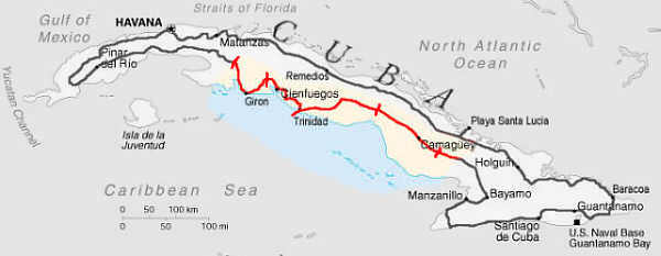
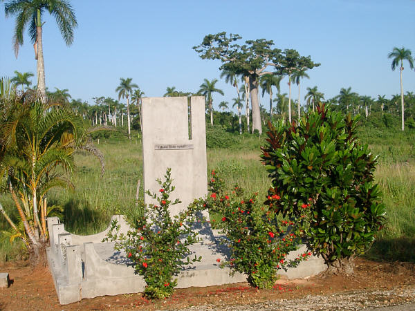
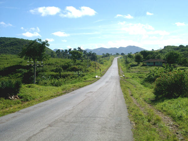
August 26: The Day by the BayJaguey Grande to Abreus At first light, I rode the short distance into town, and since I wasn't able to obtain anything decent for breakfast the day before I stopped by the town's farmer's market. For some reason nothing much looked too appealing at that hour, so I bought an avocado and ate it just for the calories, as I really don't like avocados (more on that later.) Jaguey Grande is a lively town and might have made a nice place for break if it hadn't been so early in the morning. Instead, I set out to the south, past one of the largest sugar mills on the island, the Central Australia. I was curious about this name and, though I don't have a definitive explanation, I later saw other state-run enterprises named Boliva and Peru. So it seems to me that this might be a way for the Cubans to try to identify their country with nations of the south and distance themselves from their large northern neighbor. Continuing south, the road passes over board-flat terrain that becomes swampier as you approach the coast. After a while you come to the La Boca tourist complex, which is a little resort at the edge of the swamp, with a crocodile farm and boat excursions to an historic native village far out among the mangroves. I stopped for a snack and since the store wasn't open yet I decided to take the tour of the croc farm. There wasn't a lot to see here, but there were a few examples of some of the endemic Cuban fauna that are sadly become quite rare. The tour was kind of touristy for my taste, but it was a bit of a treat to walk around with the English-speaking guide, however, as I had not been able to talk to anyone for a few days. After a quick snack, I continued south and, after another 20 km, reached the head of the Bahia de Cochinos, known to English speakers as the Bay of Pigs. The Bay was quite beautiful with small sandy beaches and rocky coves paralleling the roadway. Every few hundred meters stood a small stone monument surrounded by ornamental foliage and bearing the name of one of the 161 Cubans killed during the unsuccessful US-sponsored invasion in 1961. Eventually, you come to the town where the actual invasion landing occurred, Playa Giron. As you approach the beach there are a couple of unappologetically patriotic billboards, one of which was the only one I saw in the whole country to bear Castro's image. The other stated "Playa Giron; The Site of the First Defeat of Yanqui Imperialism in Latin America." There is a small town here, and at one point the area must have been targeted for tourist development, for there is a modest resort at the beach. Since it was the off-season, however, the hotel was closed. I had a small meal from food I bought at the lonely Dollar store, and then visited the Playa Giron museum. The museum has some military equipment on display outside and indoors are several interesting exhibits describing the history of the battle and especially the lives of the soldiers that were lost. After visiting the museum, I walked along the 200-meter-long beach for a while. The unique aspect of this beach is a rather bizarre artifact of the town's historic past. At some point in the last 40 years, someone thought that it would be good for the country's state of mind, I suppose, to build a "defensive wall" to protect Playa Giron from another attack. So, there is a long concrete-block wall that arcs out about 50 meters into the sea from either end of the beach. Whichever bureaucrat thought this would be a good idea obviously never considered the fact that another invasion could just as easily occur via any of the other thousands of kilometers of Cuba's coastline. I waded into the water for a bit, and though I really wanted to go swimming I didn't, since I couldn't find a place to change clothes. So, after a while I continued the ride, now heading east, cruising at a brisk pace through flat coastal lands, where brightly colored land crabs scurried away in fear as I approached their roadside abodes. In a little while, I met the first of only a few other groups of bike tourists that I would meet on this trip. Four Basque riders were heading in the opposite direction, and we stopped and exchanged greetings and route information for a while. They seemed to be having a nice trip, and their comments made me anticipate the days ahead even more. The rest of the evening I cruised along at a brisk pace, except for one wrong turn that took me off course for perhaps 5 km. There was an unsigned fork in the road, and as I approached, I asked a fellow who was standing at the corner "Which way is Yaguaramas?" I went in the direction that he pointed, and after a few km, the road turned into a sandy, rocky path and I knew that someone (most likely me) had made a bit of a miscommunication. No worries, though, I just turned around cruised on towards, and through, Yaguaramas. In the vicinity of this smallish village, on an otherwise unremarkable patch of roadside, there is a small monument to General Henry Earl Reeve, and American general known locally as "El Inglesito." Apparently he was of some considerable aid to the Cubans during their 19th-century War of Independence. The monument, which consists of a granite patio, a 4-meter tall obelisk, a bronze plaque describing the General and his feats, and a flagpole flying the Cuban flag, was erected in the 1980's. I assume it represents a little jab by the Cuban government, implying that they can indeed be appreciative towards Americans. Its proximity to Playa Giron is a bit ironic, though. East of Yagauramas, I veered of the main road, which was getting a bit busy compared to recent days, and rode along a beautiful smaller road towards the little town of Abreus. At the edge of town, I found a place to bed down for the night. It was a bit closer to the town than I would normally like, and I could hear the townsfolk partying late into the night. Distance: 155 km Max temperature: 38 °C; Skies: Sunny. Terrain: Very flat
A monument to a victim of the Bay of Pigs invasion
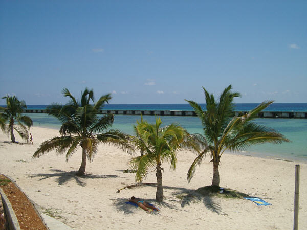
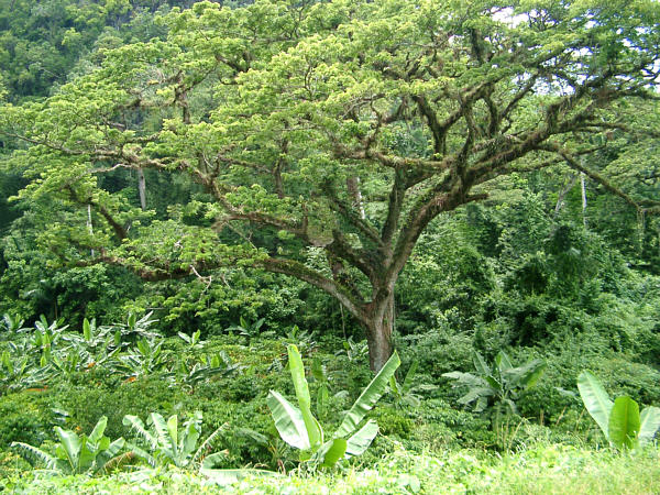
Beach at Playa Giron, with Defensive wallAugust 27: The Day of Guarapos and RocksAbreus to Trinidad This day was intended to be a bit shorter than recent days since my plan was to end the day in Trinidad where I had scheduled two rest days. So, my thought was to arrive as early as possible to have some more time to settle in and clean myself up. I awoke and packed up before sunrise, since I feared that I might be a little too close to Abreus, and an early-rising Cuban could stumble over my tent. So, I decided to ride the short distance into town and eat my meager breakfast there. Abreus was the first town that I had seen in three days that seemed to be in relatively good shape. I can't say that I could tell why that was the case, but the town's buildings appeared to be well cared for, the streets were lined with ornamental foliage, and there was a small, but nice-looking baseball stadium. I didn't worry too much about having only a small breakfast, as Cienfuegos was only about 33 km away. Cienfuegos was the first large city that I visited since Pinar, and as I approached the terrain began to lightly roll and the traffic increased. The city itself was typically Cuban, very hectic and somewhat confusing. However, it was not too difficult to find my way to the main central plaza where I had a nice break. The architecture of Cienfuegos is a bit different than other Cuban towns. There is a bit of a French flare to the civic buildings as this area was under French control in its early days. The plaza was very pretty, and I would like to have visited the museum on its edge, but it was closed. Instead, I just relaxed for a while in a nice gazebo, where, as often happened, a couple of young boys tried to start up a conversation. As it turned out, this time they were not asking for handouts, but only wanted to try on my helmet. I put it on the first one's head, and it was, of course, about three sizes too big. But he smiled anyway, and let his friend try it too. Of the millions of cyclists in Cuba, I think that I was probably the only one who wore a helmet. But the thought of all the red tape that might occur if, as an American, I needed medical help after a crash, and, worse yet, had to return home early, kept it on my head for the whole tour. After a little while the El Rapido had opened and I stopped in, mostly for the chance to use the first decent bathroom I had seen in days, but also for some much needed food. A couple of little pizzas hit the spot, not to mention a large, refreshing beverage. Since I anticipated a bit of a hot ride ahead, I bought a full bottle of water, and also a couple of cans of soda, which I stashed in my rear pannier. Leaving Cienfuegos, the main road rolls for a while through the foothills of the Sierra Escambray. I could feel the heat really begin to take hold, but since the hills were fairly gentle at this point, I cruised along fairly easily. Along the way the views of the Escambray really became impressive. The peaks were still 20 km away, and the land before them was lush and thick with green sugarcane. After 30 km, there is a fork in the road, and you are presented with a choice of two routes to Trinidad. The main road heads for the coast and follows it the rest of the way, while the alternate choice, which the guidebook that I had used for research describes as "an incredibly beautiful drive," passed straight through the mountains. I had always planned on taking the mountain route, and I only hesitated for a moment when faced with the choice of the assuredly easier coastal route. A few kilometers after the junction, the climbing started. This would be the first real climbing that I had encountered on the tour so far. At the beginning the grade was fairly reasonable, but, even so, I began to feel adversely affected by the heat for the first time. A short time later I felt the need to rest in the shade for a while, and pulled up under a tree where I powered down the two sodas that I had bought in Cienfuegos. They seemed to help a little, but I was a bit worried because the real climbing had not yet begun and there was quite a bit of distance to go before Trinidad. After a little while, still feeling somewhat drained, I continued on. A couple more kilometers passed and I came to the only village of any size on this road, La Sierrita. There didn't seem to be much there, however there was one place of prime importance--a Guarapo stand. I couldn't have imagined a more beautiful sight at that time. I walked up and the looked at the sign which read Pequeńo- 40˘, Grande- 80˘. Well, there was no question, I asked for a Grande and the woman at the stand filled a large mug with the sweet fluid. It is rather unusual to be served in a large glass like that one, but I couldn't have been happier. As I drank it down, I watched her partner preparing more Guarapos by grabbing a handful of 2-meter long canes, folding them in half and inserting them into a gas-powered press which squeezed out the juice into a big flask. The raw juice was mixed with a little crushed ice, and the drink was ready to serve. Perhaps my mind was still a little scrambled from the heat, or perhaps I was thinking I was already in the tourist zone of Trinidad, but I then made a little monetary gaff. I handed the woman at the stand a dollar bill, and as she pensively began to look around for change. I waved to her to let her know that I didn't need any change, feeling overly proud of myself for being so generous to give a whole 20-cent tip. However, what I neglected to consider was that the Cubans use the "˘" symbol to indicate both U.S. cents, and "centavos", or 1/100th of a peso. Of course, in this case, the large drink was meant to cost 80 centavos, or about 4 U.S. cents. So I probably just equaled her normal days take with just this one drink. The drink was so good, in fact, that I decided to get another. As she saw me pulling out another dollar, the woman smiled and said "No, No" and filled the glass again. I though she was just being nice, but in reality she was only trying to not take advantage of me. No matter, I was so thirsty, I would have paid $20 for the two drinks. Nevertheless I enjoyed the second one, thanked her, and rode off. Now the real climbing began. The Sierra Escambray are not an especially large or tall range compared to what I am used to at home, but some of the grades can be surprisingly steep. There were a few cases where it was tough to keep my front wheel grounded. However, the Guarapos had kicked in, I was feeling a little stronger again, and I began to really enjoy the climb. As the hill rose, the vegetation became more lush and closed in to the edge of the narrow roadway. Additionally, the skies were now beginning to look threatening, as a mountain storm was brewing. Because of this, the temperature dropped several degrees, which was a welcome change. Near the top of the initial steep climb, at about 450 meters, I encountered one of those spots where a little fall of water came squirting out of the mountainside. I decided that it would be a good idea to fill up, just in case, and so I filtered a batch of water, some went into the bottle, and some I drank right there. At that very moment, the storm that had been hovering nearby decided to let loose the type of cloudburst that one would expect in the tropics. My instincts told me to pull out the raingear and suit up, but the cool rain felt so good that I didn't bother. Instead I jumped on the bike and continued the climb. I was alone on the road and now that I felt cool and strong again, rode on like it was the start of a new day. The storm lasted for maybe 20 minutes and I had to cross over some rather deep rivulets of runoff along the way, but I didn't mind at all. At about the same time as the storm turned to drizzle, the climb topped out and the next several kilometers rolled up and down through the highlands. There were occasional homes alongside the road, some very isolated and surrounded by dozens of banana plants, others clustered in small groups. The air was washed fresh from the rain and the locals were venturing out again to go about their business, and shouted out greetings to the soaking wet Yanqui who rode by. After a little while I saw a sight that made the choice of taking the mountain route worthwhile. It has been a longtime goal of mine to see wild parrots in their natural habitat. Well, the noisy squawking that I heard coming from a tall tree on the roadside let me know that that goal would finally be achieved. (There is a flock of, perhaps, 50 feral parrots that live in San Francisco that I occasionally see, but I don't count those because they are not indigenous.) The Cuban parrot is, unfortunately, not very common these days and I felt lucky to have seen this group of a dozen, or so. Though I couldn't really make out their bright green coloring, with a patch of red, due to the position of the sun, which had now begun to peek out from the clouds. The clearing skies revealed a series of beautiful vistas of the highlands, covered with bananas, tree ferns, large epiphyte-laden trees, and occasionally splashed with color by bright red Flamboyans. But nothing good lasts forever, and after a while I passed a truck heading the other way that was carrying a bunch of men dressed as soldiers. They shouted something at me that I didn't understand, but in a few minutes I realized that what they were trying to tell me was that the condition of the roadway was about to deteriorate--severely. They probably would have said that the road was not passable for bicycles, and maybe they would have been correct. Nevertheless, I had designed my bike to be fairly capable for off-road conditions, and this would be its first test. I'm happy to say that the bike came through it better than my nerves did. I vividly remember bunny-hopping meter-wide potholes while descending 20% grades and then dodging large boulders a second later. Fortunately my sturdy wheels never complained. I don't really know how long this went on, but it seemed like a much longer distance than I thought it would be. As is often the case in such situations, I kept expecting the main descent to begin "just around that next corner". But no, the road seemed to go on and on, and get worse and worse. At one point I passed by a few people who were waiting under a basic shelter on the roadside, obviously expecting a ride from someone. The fact that they were there made me feel that I hadn't yet gotten completely lost, but I couldn't quite imagine just how long they would have to wait there and who, or what, was going to come and pick them up. By now the sun had been back out for a while and my once soaking wet clothes were now mostly dry again and, as I walked up an intensely steep grade, I began to feel hot and tired again. Walking up hills is fairly unusual for me, and I wouldn't have had much trouble riding up this one were it not for the fact that it mainly consisted of rocks the size of my helmet. I was beginning to wonder whether I might want to stop for the night while still in the hills, but at the top of this latest climb, the road became a little smoother and then, after another kilometer or so, joined up with the main road again which was nicely paved. Now back on the main road, I passed by the only building of any size along the way, a large, ugly concrete "Spa" built by the Soviets. I probably could have stopped there for some refreshments but I decided to go on, assuming that a fun decent back down to sea level was right ahead. Well, not quite. After a little while a sign pointed to the right for Trinidad, so I followed. This wasn't a road as such, but a cement path, and because of the usual joints between the blocks it wasn't possible to go very fast. This joined back up with the road after a little while, but a section of flatish riding was still ahead. Finally, the decent that I had been anticipating for hours began. However, It was not quite what I had been hoping for. Sure it was fast, but perhaps a little too fast. The road began a series of switchbacks down a steep grade that must have been 20% in places. Now, this wouldn't have been a problem were it not for the waves in the pavement that were similar to moguls on a downhill ski slope. It took all of my bike handling skills to stay upright. Even so, at one point, a rather large bump caused a bunch of my gear to fly off the back end of the bike and it was a tough task to stop and go back for it. Finally at the bottom, feeling kind of frazzled, the road met up with the coastal route that I could have taken had I been less ambitious. Looking back I'm glad I went the tougher way, I just wish that I had better information beforehand so I knew what was coming. Even though Trinidad was just ahead, I stopped here at a roadside bar for a couple of cold drinks. It was just two or three easy kilometers to the town of Trinidad. This town is one of the prime stops on the "normal" tourist's circuit, and as such is filled with folks who are a little over-anxious to rent you their Casa. I must have been approached by, or at least shouted at, by 30 or 40 people within 10 minutes of riding into town. I'm sure that some of these were nice places, but I had planned to make Trinidad my first rest stop, and as such, was looking forward to a few nights in a hotel. I had planned on staying at the low-cost Hotel La Ronda, which is right in the center of town, but it was full. Instead I ended up at the nicer, and more expensive Hotel Las Cuevas, which is a group of little bungalow-style rooms built into the hillside overlooking the town. This turned out for the best, as the Las Cuevas was pretty nice, and after several days in the tent I was ready for that. Not to mention the fact that its restaurant had an unusually nice buffet dinner, which I took full advantage of, and attempted to eat all the food that I had missed during the previous lean days. Distance: 131 km Max temperature: 38 °C; Skies: Sunny, one big thunderstorm. Terrain: Rolling, then Mountainous
Lush tropical foliage in the Sierra Escambray Mountains
View in the Sierra Escambray MountainsAugust 28-29: Rest Days in TrinidadTrinidad is referred to as "Cuba's Museum City," because of its relatively undisturbed historic section that has been continuously occupied for around 500 years. I don't think that any of the buildings in the town today are quite that old, but it doesn't really matter, the colonial atmosphere is still intact. The historic section is closed off to most motorized traffic and the streets are still paved with cobblestones. The corners of some of the older buildings are protected by old iron canons, which have been tipped up vertically with the open end cemented into the sidewalk, forming a sturdy bulwark. The busy time of day is an hour, or so, either side of noontime, when the large, air-conditioned, black-windowed tourists busses arrive from other parts of the island and unload their cargo of tourists. These folks then get a couple of hours to walk around, see a minimal amount of the city's sights, getting blitzed by the many arts and crafts vendors who have their slick presentations down to a science. Shortly thereafter, the busses gather up their passengers and head of for who knows where. After that the town returns to its more preferable relaxed state that is typical of the early mornings and evenings. These times were much more enjoyable to me and I did most of my sightseeing then. I was quite interested in the historic aspects of Trinidad, but only two museums were open at the times when I was there. At the Military History Museum, there were many displays on the events of the People's Revolution, including a piece of the U.S. spyplane that was shot down during the 1962 missile crisis. The Museum of Architecture was more what I was looking for, and contained some interesting exhibits on buildings from the colonial period. A guide walked me through the museum, and though I couldn't really understand her Spanish, I got the idea of the place. On the way out, I noticed what was apparently some sort of Fiesta, with the guest of honor, a young girl, dressed up in what almost looked like a wedding dress. The guide told me that it was the girls thirteenth birthday, and it was a tradition in Cuba for her family to throw a big party for her on that day. The rest of the day, I basically relaxed and enjoyed another good-sized meal at the Las Cuevas. Later in the evening I took the opportunity to fix the only mechanical problem, other than tires and tubes, that I had on the whole tour. A couple of days, earlier, I had gotten the cleat of my right shoe all clogged up with mud. I was using SPD pedals on this trip (I've now switched over to the LOOK version of EggBeaters,) and I wasn't paying enough attention when enough mud jammed into the pedal that it wouldn't release. Of course, even though I knew that it was a stupid thing to do, I gave my foot a strong twist until it finally popped out. In doing so I twisted the cleat in such a way that it dug into the shoe's sole and would no longer stay in the proper place. Fortunately, I was able to shave off enough of the sole with a pocketknife to make a flat surface for the cleat to mate against, and this repair held up for the rest of the tour. On the following day, I planned to spend the entire day at the nearby beach, Playa Ancon. I was quite excited about this, as I hadn't had an opportunity to swim in the ocean since I moved to the San Francisco area almost 10 years earlier. The beach is about 8 km from town, and I decided not to ride so I wouldn't have to watch out for the bike all day (not that I would have needed to pay much attention to it in any case.) To get there I used a CocoTaxi, which is basically a small three-person motor scooter with a yellow fiberglass dome over the seats. It was the only motorized transport I used on the whole trip except for the taxi to and from the airport (and the airplane, of course). The beach was beautiful, nice white sand placed up against an azure ocean, which was the perfect temperature for swimming. There are a few "western style" hotel resorts along the beach, but it was still the off-season, and they were almost deserted, the ideal situation for a restful nap on the beach. In the afternoon I walked up and down the length of the beach, and at one end there is a section where most of the locals hang out. As I walked along a young fellow came up and started chatting. I was expecting the usual solicitation for his wonderful Casa, but instead he brought me over to meet his friends. They were simply interested in meeting an American, and getting a chance to speak a little English. They told me about the music festival that would be there the next day (too bad I was heading out of town,) and said that the Cubans have nothing but good feeling toward the ordinary people of America. I replied that a lot of Americans felt similarly about Cuba, and we agreed that it would be better if the crazy political situation were not so crazy. One of the fellows had a big bag of homemade crackers and he was too polite to try to sell some to me. I probably felt a little glad since most everyone seemed to want to sell you something. But as I walked away, I decided that I could indeed use some tasty crackers, and ran back just as they were leaving as well. I gave him fifty US cents, and though I only wanted a handful, he wouldn't let me leave without a big bag of them. They were quite tasty, too. Then it was back to the Las Cuevas, for another big meal and a good night's sleep before heading out again the next morning. Max temperature: 35 °C; Skies: Sunny, Evening thunderstorms which knocked out the hotel's Internet connection.
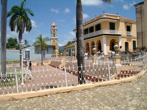
Plaza Mayor in Trinidad
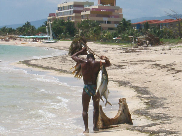
A fisherman brings in his catch, Playa AnconAugust 30: The Non-Eventful DayTrinidad to east of Ciego de Avila Feeling rested and ready to go, I set out again early in the morning. The road heading east curves inland just after Trinidad, and after several kilometers you reach the Valle de Los Ingenios. This is a wide, lush valley that was one of the original sugar-growing regions in the West Indies, and along with historic Trinidad, is another UNESCO World Heritage Site. There isn't much in the way of actual places to visit in the valley, apart from its famous landmark, the old Bell Tower that was used to signal the workday shifts to the slave labor which originally worked the plantations. There is still a large amount of sugar grown here and the scenic beauty of the valley made for a nice ride. After about 20 kilometers, the road began a gradual climb up to a plateau that dominates the spine of the island in this area, rising up to about 300 meters. The grade was quite easy, and the countryside varied from hilly grasslands dotted with large, bushy broadleaf trees, to narrower valleys flanked by craggy green peaks. A nice vista of a rather large reservoir came into view just as I approached what would be the first of a series of larger cities located in the southeastern portion of the island, namely Sancti Spiritus. Sancti Spiritus seemed to be a fairly nice town, and I stopped here for my midday break and to run a couple of errands. The first, the daily hunt for food, was performed easily enough, but the second proved to be a bit of a comedy of errors. The TransCard that I had ordered was not ready in time for me to pick up in La Habana, so the company sent it to their office here, where it should be waiting for me. The address I had was 171 Calle Independencia, which was the main street through the center of town, so I thought it would be easy to find. As it turns out the building numbers started at 1 at the central plaza and went up as you went in either direction. So I started out by going east but soon noticed that the numbers skipped from 160 to 195. No problem, I thought, and went of to look in the other direction. This time there was a 171 but it was on an unmarked blue building with no windows across the street from one of the old churches. Somehow that didn't seem right, so I spent what seemed like forever riding back and forth along Independencia in case I missed something. Eventually, I decided to try phoning for directions. This would be my first experience with Cuban phones, and after a while I found one of the small glass kiosks run by the phone company, ETECSA. The agent there sold me a $5 phone card and I called the number for the TransCard office. Well, the woman who answered the phone did not understand even one word of English, and with as tired as I was beginning to feel, my Spanish must have been almost incomprehensible. So that didn't work at all. The only option left was to go back to the blue building, which seemed like the best lead. So, I opened the heavy wooden door, which revealed a long, dark staircase. At the top was a long hallway, also dark. After a left turn, and a right turn were a couple of unmarked wooden doors with glass windows. At this point a woman came walking down the hall and I (rather sheepishly, as I wasn't sure whether or not I was sneaking around in someone's home) asked if this was the TransCard Office. She pointed to one of the doors. I entered to find a single desk where the woman I had spoken to on the phone was seated. Her English had not improved, nor had my Spanish, and it seemed like it took twenty minutes for me to explain that there was a TransCard there for me to pick up. After I managed to make the point it was all smiles. A little bit of paperwork later, and I had my card. The whole episode did chew up most of my planned rest break, however. In the afternoon, I continued east. Now fully on top of the plateau, the terrain flattened out considerably. Of course, to compensate, the wind began to pick up a bit, giving the first significant headwind of the tour. This was not nearly as bad as I imagine it can get when the tradewinds really start to blow, and I continued on without too much difficulty. There are a couple of nice views along the northern shoreline of the reservoir that I had seen in the morning. Cuba has not industrially or residentially developed most of its waterways, and they remain in a quite lovely natural state. Just east of the town of Jatibonico, the Carreterra Central picks up a lot of traffic from the Autopista, which has its eastern terminus just to the north. For the first time, the amount of motorized traffic almost approached the levels of a moderately traveled road back home. I realized right away just how spoiled I had become over the past several days. I continued on through the small city of Ciego de Avila where I stopped for another short break. I left town in the late evening in order to get far enough away from town by nightfall. It was a fairly tough task to find a place to sleep for the night, as the area east of town did not have much in the way of good cover. Darkness seemed to approach much more suddenly than usual as well. Eventually, I located a spot in a thicket along a dry streambed. It was not quite far enough from the roadway to lose all of the traffic noise, but it was the best I could do under the circumstances. Distance: 163 km Max temperature: 39 °C; Skies: Sunny, light afternoon shower Terrain: Gentle climb, then flat
The Valle do Los Ingenios north of Trinidad
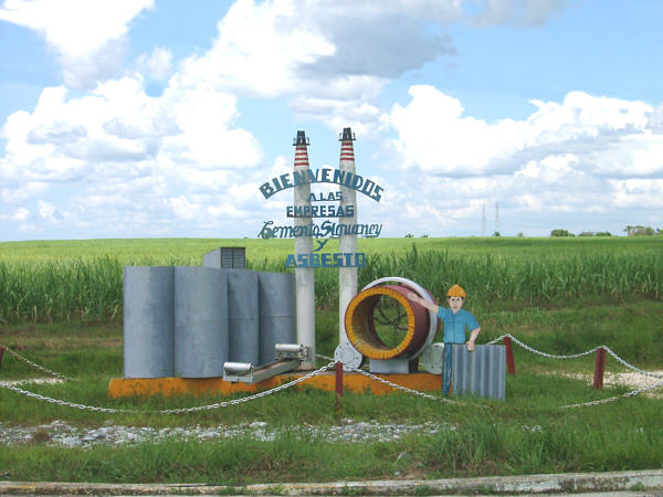
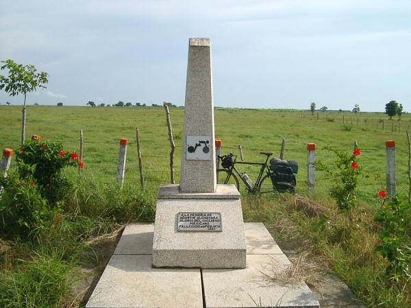
Climbing the plateau on the way to Sancti SpiritusAugust 31: The Day of the TrucksEast of Ciego de Avila to Sibanicu The morning started with the not-to-surprising realization that I had a flat in my rear tire from a thorn that I must have encountered while pulling the bike through the bushes the night before. In, fact after I made a patch, I discovered that, in fact, the tube had been punctured twice, in separate locations! These were some serious thorns, too. They were probably 3 cm long, and the bushes to which they belonged were covered with them. No matter, the repair was made, and for the rest of the tour, when walking to camp, I kept reminding myself "No more thorns." For lack of a better description, I have named this day after its one distinguishing feature, trucks. The traffic on the first part of this route was the heaviest of the whole tour, except for within the big cities. Most of this was still traffic that was once travelling on the Autopista heading for Camaguey, and the number of fast-moving trucks was many times more than on any other road I traveled. I don't mean to overstate the situation, however. The actual amount of traffic was no more than an "average" intercity roadway back home. I was just that compared to the days that had just gone by, it sure seemed like a lot. Though, if one were looking for a section of the tour route to skip, this might be it. Additionally, the landscape was a bit less interesting than other places on the island. Still up on the plateau, the countryside was open and grassy, with many cattle ranches along the way. That's not to say that there was nothing of interest, such as some very pretty, broadleaf trees whose branches were packed with epiphytes, and another tree I saw alongside the road whose trunk was completely covered with short, stubby thorns. There was also a moderate headwind to contend with on this section, though it was nothing that I couldn't handle. I stopped for a break in the pleasant little town of Florida. It had a quiet, shady park, and a couple of decent places to get food, but not much else. There wasn't a very good way to break this day up into morning and evening sections, so after a short rest, I continued on to Camaguey. It was only another 34 km to the city, but it seemed like a lot longer than that. One notable sight along the way was a stone obelisk on the roadside with a symbol of a bicycle on it. Such an object deserves a closer look, and I read on the plaque at the base that it was dedicated to Augustin Alcantara, a Mexican bike racer who was killed on that spot in during a race in 1978. It was nice that this sad event was commemorated, but it's not the kind of cycling monument that I think this country deserves. Camaguey is one of the larger cities on the island, and it seemed to me to have a more urban feel than the others that I had passed through recently did. In fact, it felt so hectic that I wasn't able to do much relaxing there. So, when some threatening thunderclouds began to approach, I didn't hesitate to leave town quickly in an attempt to outrun them. As it turned out, I was able to do just that, and, even better, the ride to the east of town began to be more fun again. The traffic that had been heading for Camaguey didn't seem to be interested in going any further. So, the roadway was now back to "normal" (read: almost deserted). There was also a bit more variety in the landscape, and the winds had died down as well. This allowed me to cruise on at a better pace than I had been making earlier, and I made a few more kilometers than I had been planning for the day. Near sunset I passed trough the small town of Sibanicu. There was a street party going on and some pleasant fellows insisted that I sample a couple of little sandwiches made from meat carved of their roast pig. They were pretty tasty, once I picked off the big globs of fat that they had added for "flavor". Just outside of town, after a good bit of searching, I found a decent spot to bed down for the night. Distance: 161 km Max temperature: 34 °C; Skies: Sunny, afternoon clouds, moderate morning headwind Terrain: flat
"Welcome to the Siguaney Cement and Asbestos Company"
The monument to cyclist Agustin AlcantaraNext: On to Oriente§ Main § Section 1 § Section 2 § Section 3 § Section 4 § Section 5 § |