
Gondwana's Climate Threat
Change is constant; unwelcome change is on the way
W ith a handful of notable exceptions, the Himalayas, the Andes, a few other alpine ranges, Patagonia, the extreme southern fringes of Australia and Africa, and, of course, the ice-bound continent of Antarctica, modern Gondwana is a very hot place. I certainly have a new appreciation for that fact after cycling through places like the Red Center of Australia, India during its pre-monsoon heat, the lowlands of Botswana, and the steamy interior of Brazil. Given the choice of touring though extreme cold or extreme heat, I would chose pleasant 25 °C temperatures instead, thank you very much. It appears that we, and our progeny, will have to make many other, much more important, decisions involving climate in the years to come, however.
First, let us dispense with any of the harmful distractions forced upon society by those who seek to delay any policies aimed at mitigating the effects of the climate forcings we have been initiating for many years. As someone whose education and professional life has been focused on science, it has long been clear to me that the following statements are the only relevant issues regarding this topic:
- The actions of humans over the past 2,000 years,
especially during the last 200, notably; deforestation; the release of
synthetic gases, such as chlorofluorocarbons; and the combustion of
stored hydrocarbon deposits, coal, petroleum, and methane, have altered
the composition of minor components of the Earth's atmosphere.
- Such changes, which alter the absorptive
properties of the atmosphere as a whole, will alter the energy balance
of the entire planet and, with the current composition, increase the
energy retained at the surface.
- Such changes will affect all of the dynamic processes which distribute energy around the globe, and upon which the biosphere depends, in a way that will probably never be completely predictable.
Those facts, stated in such a cold, detached form, nevertheless cut right to the heart of our society's future survival. It is often said that efforts to prevent catastrophic climate disruption are done in order to "save the planet." Such positions, while well-meaning, miss the point entirely. The Earth has shown a splendid ability to accept and adapt to drastic changes in climate, many times over its history. It is our society, our civilization, all of the best products of our socities, and the collective labors of our ancestors, that need saving. It would seem to me that with so much at stake, the need to understand and prevent the possibility of a rapid disruption if the climate would have been a priority for our species since we first realized the situation. It is probably a testament to our nature as a species that it has not been, I suppose.
One additional fact, that I can add to the three above, is that most of the human behaviors that contributed to the creation of the situation in which we find ourselves took place in the northern section of the World, and that many of the first places to feel the effects of the changes to come will be in the south; in the lands of the former supercontinent, Gondwana. I wanted to see, as best I could given the limitations of a long bike Tour, which parts of the lands that I would visit were most threatened from evolving climates changes, and try to imagine what might happen to the people and the ecosystems that exist there. That was certainly not easy, as the issues are very complex, but, as with other subjects, time and patient observation make such issues appear slightly more clear. Here are my thoughts after sweating across five continents.
The Most Worrisome Issue
The extra energy retained by the Earth, once it has a more infrared-opaque atmosphere, is going to go somewhere within the outer "spheres" of the planet, the hydrosphere, for example. As the capacity for such systems to absorb additional energy is not infinite, flows of energy will alter themselves in order to disperse this energy as uniformly as possible. An example of such energy dispersal is more commonly referred to as weather. While weather and climate are distinctly different entities, both can have profound impacts on our societies. We have all heard examples of potential impacts of a changing climate, most of which would severely disrupt the human enterprise. Sea levels may rise, driven by melting ice, as well as thermal expansion of the oceans themselves, causing intrusion of saltwater into prime agricultural lands, and flooding coastal regions. Super-cyclones may become more common causing massive loss of life and the destruction of developed infrastructures. Tropical diseases like malaria and dengue, may expand their ranges into regions thought to be forever free of such maladies. Other effects may not be apparent to us now, but could prove to be equally problematic.
However, while all of these factors would lead to severe difficulties, and should not be discounted, after traveling though the continents that are fragments of Gondwana, I feel that the potential climatic shift that should be of most concern as we seek to adapt to different conditions is perhaps the least sensational of all; long term variation in established rainfall patterns. While the other aspects mentioned above can be devastating to local populations, especially those living at the coastlines, widespread changes in rainfall distribution can affect everyone. Changes in atmospheric circulation in a higher-energy world, as well as modification of evaporation rates caused by widespread deforestation, can play a role in such changes. A potentially larger factor would be significant changes in the major ocean circulation system of cold and warm currents. Inflow of fresh water from melting ice into the oceans has been proposed as a potential trigger for such changes. Warm ocean water where it has not historically been, or cold water in a formerly warm area, will have a rapid and significant effect on the rainfall in many regions.
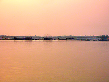
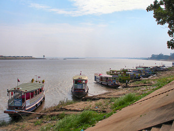
Anyone who has lived in the parts of the World affected by the Pacific Ocean ENSO, also known as the El Niño/La Niña cycles, has seen first hand just how significant such a change can be. An example from an area of the Tour is the Pacific coast of Peru. During an El Niño event, warm waters pool up against the west coast of South America. The plankton of the region, together with the fish and other larger creatures that feed on them, move away to nutrient-rich, colder waters elsewhere. The area's fishing industry, like the fleet anchored off Chimbote, Peru, shown below, face a catastrophic loss of their livelihood. Meanwhile, on land, torrential rains cause intense flooding, and severe erosion problems in the normally arid coastal region. This has, in past cycles, significantly degraded important archeological sites such as the ruins of the ancient adobe city of Chan Chan, at Trujillo, Peru. I had been concerned when planning the Tour, that I would be negatively affected if I got the timing of the El Niño/La Niña cycle wrong. For once, I was fairly lucky, and I arrived in that region when there was a neutral sea, or possibly a mild La Niña pattern, and so for me the weather was good.
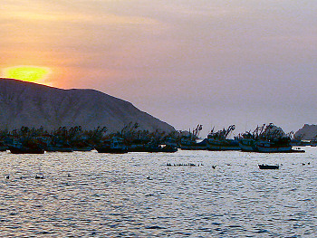
The fishing fleet of Chimbote, Peru on a January evening
Dependability is Everything
Fresh water is the most critical component for maintaining the activity of the entire terrestrial biosphere. That is to say, fresh water is the most critical component for the survival of human societies. Both natural ecosystems and tradtional human civilizations have developed in concert with their local climates, and have become perfectly attuned to the patterns of rainfall that have prevailed during the current climatic epoch. Alterations in the amount of water available for any locality, especially if that change occurs fairly quickly, may exceed those system's capabilities to compensate. Droughts or inundations, where either are not common, can lead to widespread crop failures, or the extinction of wild species. Most natural environments may well be able to absorb certain levels of stress in their water cycles, at least until a local tipping point is reached. Some human systems may be more fragile. With a more energetic Earth, warm and wet, or warm and dry will be a key question for each region.
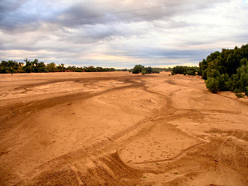
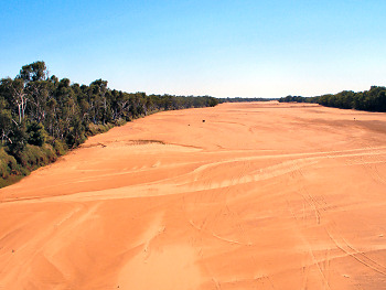
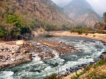
Australia is well known for its semi-arid and arid environments. The tenuous grip with which agriculture exists in the Outback and other dry areas has continued only at the mercy of the occasional rains. When I passed through southeastern Australia in Stage 1, it certainly seemed to rain a lot, a fact that made the local residents ecstatic, as any rain helped to alleviate the multi-season drought that had been ongoing in the region. It seems to me, however, that drought is actually the more normal condition on that continent, and rains should be considered to be the unusual event. With something like 90% of the continent exhibiting dry conditions in the best of times, as evidenced by the two dry rivers shown below, any move towards hotter, drier conditions there would pose huge problems.
The dry Gilbert River, in Queensland, eastern Australia
The dry Gascoyne River, in Western Australia
Deserts are common in modern Gondwana, the most significant being the expansive Sahara, of course. I like to visit them from time to time, but generally prefer to spend only a little time there when on Tour, as I much prefer the verdant green of a thick forest. It is often only a matter of a small difference in rainfall between a desert and more productive grasslands. In Africa, the bleakest desert I rode through on the Tour was the flat, barren Dida Galgalu in northern Kenya. The few nomadic people who lived there are probably faced with the toughest life of any of the traditional peoples I have seen over the years. The very basic huts in which they lived can be seen in the image below, in the distance, just to the left of the swirling dust-devil. The difference of between that area and the nearby grasslands, famous for their large, but ever-decreasing, herds of wildlife, is slight both in terms of distance and climate. Any decrease in rain in the surrounding areas will force many people into a similar life, or cause them to become climatic migrants.
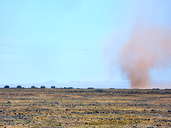
The parched Dida Galgalu Desert in northern Kenya
At the opposite extreme, dependability is key as well. The image below shows the annual flood of the forests of the Amazon basin, near the Yarapa River in Peru. The entire ecosystem is adapted to the regularity of this event, and as long as it continues, the system there can remain healthy. The waters which inundate the forest originate in the seasonal runoff from the eastern Andes, as well as from the locally spawned storms fed largely from transpiration from the forest itself. Decrease in the Andean snowpack, and deforestation in the lowlands are factors which could influence the continuation of this annual event.
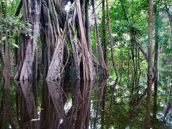
A Flood Forest in the western Amazon basin
The slow draining of these accumulated waters is a main reason that the Rio Amazon is the World's greatest river. The image shown below was taken at Iquitos, Peru, thousands of kilometers from the river's mouth, where oceangoing vessels may still navigate with ease.
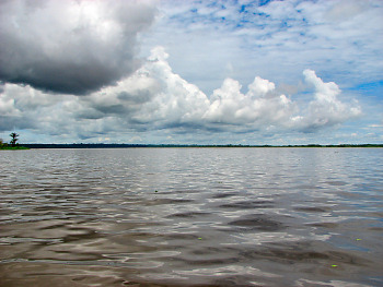
The mighty Amazon
At the peripheries of this region the annual changes between wet and dry are more pronounced, and the creatures living there face a more challenging set of circumstances. In Brazil's Pantanal, which in the wet season is the World's most extensive wetland, the dry season leads to high concentrations of fish in continuously evaporating ponds. This creates an abundant buffet for the local jacare caimans, the local variety of crocodilian, many of which can be seen in the following image. Those fish that survive that onslaught must still hope that the dry season is not more severe than normal, which could literally turn them in to fish out of water.
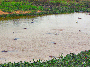
Jacares gorge themselves in a rapidly shrinking Pantanal pond
Mountain Ice to Drink
While their loss will not affect sea levels as drastically as melting polar ice would, the retreat of mountain glaciers can also pose serious problems for surrounding areas. While some may think that glaciers will only disappear if the surrounding temperature becomes warmer, that is only one factor in their stability. In addition to freezing temperatures, glaciers require a certain amount of annual precipitation to maintain, or increase, their flow downhill. Glaciated areas where changing climate causes a significant increase in temperatures, but also leads to reduced precipitation, can see a retreat of glaciers, though perhaps only slowly. On the other hand, glaciers that experince warmer temperatures, but also increased precipitation, may, in fact, grow larger. As glaciers provide a natural reservoir for storing fresh water, many of the areas that have come to depend on their runoff in drier times could face difficulties if they were to shrink significantly, or disappear completely.
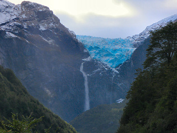
Seeing glaciers on a bicycle tour is not always an easy undertaking, especially for those located high in the mountains. However, on the Tour I did manage to encounter a few nice examples, which have not liquefied just yet. This was the most southerly I saw, located at the edge of the Canal Beagle, and flowing down from the Cordillera Darwin, in extreme southern Chile. At that low latitude temperature and precipitation both seem to be adequate to maintain such ice for now. However, with thawing already occurring in Antarctica, even farther south, that is by no means a certainty.

A Glacier at the edge of Chile's Canal Beagle
Father north lies two remnants of the fairly large
Patagonian Ice Sheet, the largest continental ice cap apart from
Antarctica or Greenland. The glacier shown below is the famous Perito
Moreno Glacier, in Argentina's Parque Nacional Los Glaciares . Most of the glaciers extending from the ice cap are in retreat today, however, Perito Moreno, which is a major eastward-flowing glacier of its southern portion, has apparently been fairly stable for the past 90 years. While the very thinly populated areas of eastern Patagonia, are probably not extremely dependent on melt waters from these glaciers, Perito Moreno is economically important, as one of Argentina's top tourist attractions.
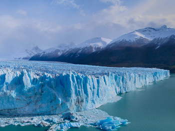
Perito Moreno Glacier in Argentina's Parque Nacional Los Glaciares
Continuing northward, the permanent ice thins further. Below is the Glaciar Colgante, in Parque Nacional Quelat, near Chaiten, Chile. It does not possess the imposing appearance of some glaciers, but its rapid runoff nourishes the thick temperate rainforests below.
The hanging Colgante Glacier above western Patagonian rainforests
The southern ice-covered areas of South America are not surrounded by large human populations, and so were they to disappear, relatively little impacts to the region's societies would be expected. Effects on the area's ecosystems, however, could be more profound. There are other regions where settled areas exist in a higher state of peril, however. The northern Bolivian Altiplano is one of those. The image below shows the fringes of La Paz, whose metropolitan population of over 1.5 million derives most of its fresh water from the snowpack on the Andean peaks in the distance.
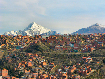
Snowy peak beyond the homes of La Paz, Bolivia
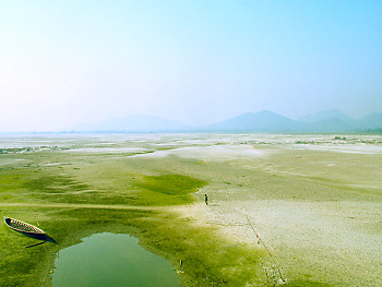
The next image demonstrates the issue more clearly, I believe. Fresh water on the Altiplano is a scarce resource. If not for the seasonal load balancing effect of mountain ice, serious shortages could develop in such places. Located at only 16 degrees south latitude, an increase in regional temperatures could quickly cause disruptions requireing a massive population shift.
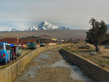
A minimal water source on the Bolivan Altiplano
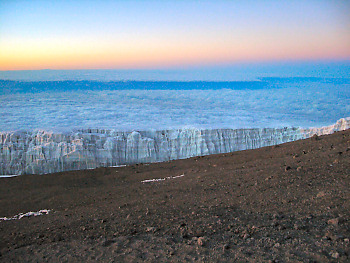
The Snows of Kilimanjaro
Seeing the famed glaciers atop Mount Kilimanjaro, the massive extinct volcano in Tanzania, was one of the primary reasons I left my bike idle for a few days and made the tough, but fascinating, trek to its summit. It has been established for some time that the glaciers on the mountain are retreating rapidly, and may disappear entirely within my lifetime. As one reaches the upper elevation limit of large plant growth, and breaks through into the more barren Alpine zone, the glaciers are constantly visible. At that point, they seem less than impressive, as this image of Arrow Glacier demonstrates.
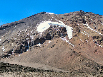
Arrow Glacier, below Uhuru Peak on Mount Kilimanjaro
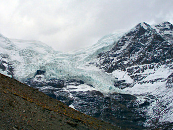
Once one reaches the summit and sees the ice up close, the actual scale of the glaciers becomes apparent. Actually, for me, that did not happen until I began the descent back down, as I reached the summit while it was still shrouded in pre-dawn darkness, but that is another matter. Guides who accompany climbers can attest to the differences in the extent of the ice in that location, as changes have been noticeable during the length of a typical five-to-ten-year career of a guide on the mountain.
The glacier near the summit of Mount Kilimanjaro
The loss of the Glaciers of Kilimanjaro will be more of an emotional and cultural situation as opposed to the loss of a critical resource. The ice-topped mountain so near the equator has been with us throughout all of human history, and its end will come rapidly, at the end of the brief industrial age. Howver, the unique ecosystem on the upper sloes of the mountain, and the human communities further down, will probably not notice drastic changes. Due to the low atmospheric pressures at its six-thousand meter elevation, Kilimanjaro's glaciers lose a considerable fraction of their mass by sublimation, as opposed to melting. The fraction of the ice that liquefies only feeds rather small streams, like the one shown below. This is in stark contrast to glaciers in other parts of the world, where much more significant water flows usually emanate from their bases. The waters that nourish the lush vegetation of the mountain's lower slopes come instead from the mists and clouds which usually enshroud its base. Nevertheless, our World will be a little less distinctive when the ice has been lost from the great mountain.
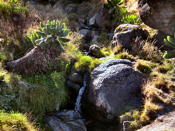
Glacial runoff down the slope of the mountain
The Himalayan Gamble
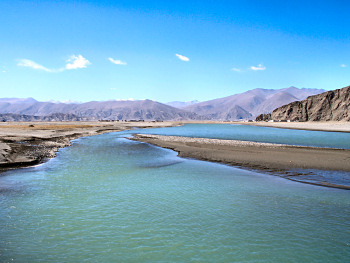
The most intense mountain range on Earth, the Himalaya, together with the equally lofty Tibetan Plateau, provide the source waters for some of the World's most impressive rivers. Among these are the Yangtze, Huang He, Salween, Mekong, Ayerawaddy, Brahmaputra, Ganga, and Indus Rivers. A subset of these comtains a few of the rivers which assisted the formation of at least two of humanity's earliest civilizations. Today, these rivers have not diminished in importance to the lives of perhaps a quarter of the human population.
Imagine you were a block of ice, existing on the face of this glacier above the Karo La, a 6,000-meter pass in Tibet. Then, on one particularly warm August afternoon, your hitherto stable and uneventful existence comes to a shocking end with a dramatic transformation, as you begin to liquefy, and then crash down to the rocks below. Before long, you are completely in a fluid state, and, yielding to the irresistible pull of gravity, begin your long descent to the sea.
A Glacier above Karo La, Tibet; a Pass at 5,000 meters
If you initially rolled down a southeastward-facing slope, you may find yourself, before long, a part of the Phung Chu. Numerous rivers like that one wind across the barren extremes of the plateau, their chilly waters meandering through the sand and rocks, benefiting precious little plant life along the way.
The Phung Chu begins its run down the Tibetan Plateau
As the kilometers pass, you will be joined by the flows of many others, and the local population will now refer to you as the Yarlong Tsampo. Your crystal clear waters are yet to support much in the way of plant life.
The Yarlong Tsangpo gains a significant flow
Your course, initially due east, eventually turns southward, gaining power as your speed of descent increases. After another change of direction, you now flow due west, altering your original course by around 180 degrees. By now you are close to sea level, and your flow has slowed, expanding into a broad, low-banked channel. You have now garnered the name Brahmaputra. The people who
live in your watershed are used to your changes of levels and your shifting sandbars. They have built movable river ports that allow goods and passengers to be brought over the sandy expanse, to wherever the riverboats can most closely approach in order to receive their loads. The residents of the large cities nearby have probably only grudgingly accepted the dust that is blown up from your channel, which, when combined with their own thick emissions, blocks much of the incident sunlight from reaching your surface.
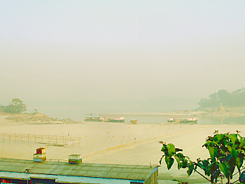
The Brahmaputra River beneath the haze of Guwahati, India
Not long after a final turn to the south, you are joined by another might river, the Ganga. Its waters also tell a fascinating story, beginning at the western reaches of the same mountains in which your journey began. Its course brought it through one of the most ancient and heavily populated parts of the planet. Millions of those living in the region have traveled great distances to cleanse themselves in its scared waters. Having run through hundreds of kilometers of urban and agricultural areas, its waters are laden with silt and human waste products. Combining with your equally thick fluid, the now joined waterway exhibits a distinct brown coloration.
The Ganga arrives from the opposite direction
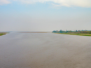
The combined river is now the Padma, and its incredibly wide channels more closely resemble an inland sea than a river. You are now the main waterway for the riverine nation of Bangladesh, and boats of all kinds continuously wind their way around your labyrinth of channels. In a short while, however, your long journey will be complete, as you pass either through a great delta, or more slowly thought the vast mangrove forest known as the Sunderbans, finally reaching the salty waters of the Bay of Bengal.
The Padma River soon reaches the Bay of Bengal
However, if your initial fall from the Himalayan glacier caused you to roll off in a more northeasterly direction, you may have taken a completely different course. In that case, after a long path across the plateau, you might combine with other small rivers, and emerge in the foothills as the Mekong. Your flow through the nation of China will soon be interrupted by a number of relatively recently constructed dams. Once those obstacles have been cleared you will enter the region known as Southeast Asia. There, enhanced by frequent rains, and occasional tropical cyclones, your power and flow will increase dramatically. You will now be a part of a river that has been a major transport corridor for millennia.
The Mekong River in northern Laos
Your southerly course continues, with additional flows joining inexorably to widen your channel.
The Mekong River, also in Laos
Your waters, and those of your tributaries, have provided sustenance to those living in the area since prehistoric times. Many still make use of traditional ways to harvest the life found beneath your surface.
Fishing traps on a Mekong tributary in northern Cambodia
As your channel continues to expand, people also make use of your banks as home sites.
The Mekong at Chhlong, Cambodia
For the final section of your journey, additional tributaries, such as the Tonle Sap, join your course, making your delta at the coast of the South China Sea, one of the World's greatest.
The Tonle Sap joins the Mekong at Phnom Phen, Cambodia
for the final stretch to the Sea
Yet another possibility may arise were you to initially tumble down the southern face of your former glacier. In that case, your journey might be considerably shorter. You may soon find yourself a part of a rapidly descending river, such as the Kuru Chu, cutting steep gorges through the southern slopes of the Himalaya in Bhutan as you plunge down one of the tallest range fronts to be found anywhere.
The Kuru Chu descends an alternate route through Bhutan
Your ultimate fate in this case would depend greatly on exactly when your fall from the glacier occurred. If it were during the annual monsoon season, when intense rains would reinforce your flow, you might emerge into the broad plains known as the Tarai where you would contribute significantly to an agricultural region that feeds millions. If, however, you began your journey during the dry season, the combined melt waters from your glacier and the rest of the snowpack in your watershed, would be inadequate to sustain the flow of your channels as they widen at the base of the Himalayan foothills. Your remaining water would evaporate into the intense heat of the Indian subcontinent, and your channel would become one of many dry riverbeds at the northern edge of the Tarai. Local people would venture out onto the rocky expanse, mining gravel and sand for use in various human industries. In this case your journey to the sea would end incomplete of its goal, your ability to provide assistance to the societies in the area would be brief and perhaps inadequate.
A Dry Riverbed near Barpeta Road, India
What is the point of this comparison? Simply that the huge portion of humanity that lives in the region surrounding the Himalaya is intimately connected, perhaps more so than most others, to the predictable patterns of rainfall that feed the region's rivers. If the Himalayan ice cover and snowpack degrades through increased temperatures, decreased precipitation, or both, the regular patterns of river flow that the societies in the area have coevolved with may shift in unknown ways. A river like the Mekong, fed mainly by rains in its lower reaches, may not be affected much at all. On the other hand, the rivers of the southern slopes may be dry for much longer periods each year, and even the major Brahmaputra-Ganga system could see its dry season flows reduced to undesirable levels. With agriculture in that region heavily dependent on irrigation from these rivers, tens of millions of people cold be affected.
There Are No Answers
I strongly support all efforts to develop new technologies that might avoid continued emissions of the gases which most strongly alter the radiative absorption of the atmosphere. Even more so, I would like to see a wholesale redesign of all aspects of our current society to eliminate, as much as possible, the need to consume significant quantities of energy in order to improve the quality of people's lives. However, realism must also be acknowledged in this case. The political-based approaches to the problem that have been proposed to this point are almost certainly doomed to inadequacy, at best. For they, without exception, completely dance around the main issue. In the absence of any demonstrably practical, safe, and large-scale methods for carbon sequestration, a process that I believe we should be extremely cautious about relying upon, the global hydrocarbon industries must shrink to a fraction of their current size, and do so quickly, if we are to have any hope of stabilizing the composition of the atmosphere. It does not take a prophet to imagine that such a major change in the structure of the corporate world will undoubtedly be met with fierce resistance, or, at best, the paralysis of endless debate.
We should expect that changes to the climate of the Earth will continue and in all likelihood accelerate. Warm and wet, or warm and dry? Again, that will be the key question in each region of the world as we move forward. The lands of Gondwana especially so. For deserts are already the defining biome of that great region. Around 80%, by area, of the World's deserts are located in the fragments of Gondwana, comprising about 36% of their total land area. While deserts are an important ecosystem, we probably don't need many more of them in that part of the planet, so warm and dry could be disastrous. Warm and wet could possibly be a more survivable situation. Perhaps somewhat paradoxically, most of the World's current, and former, tropical rainforests are also located on Gondwanan lands. If, after the initial period of erosion and degradation of areas that are currently drier, increased rainfall allowed forests to expand, a negative feedback could be put into place. That is, if we were to actually allow the new forests to grow to maturity. Since the forests already clinging to existence in the southern World are even now facing increasing pressures, resting our hopes on a warm and wet southern World seems unlikely to ameliorate our problems, as the chances of that region becoming a new carbon sink seem remote.
The answer to that fundamental question may not be predictable, as rainfall patterns can be more difficult to model, compared to, say, sea-level rise. The changes may not be the same everywhere and this will lead to a variety of challenges for the global society as a whole. So, developing any strategies in advance to deal with these changes will be problematic indeed. Furthermore, as there can be no honest way to deny the culpability of the northern world in the creation our current situation, is should be incumbent upon all of those from that part of the World, myself included, to accept the responsibility of assisting the rest of the World's peoples, many of whom live on the increasingly hot parts of Gondwana. Large-scale migrations may need to take place, redistribution of agricultural production may need to be arranged, adverse health effects will need to be addressed, and whatever other adjustments may be required will have to be made. At this point it seems that there are few other things that we can do.
Hold on, that's not quite right, there is something that each of us can do. Ride your bicycle.
Previous | Next
Main Index | Pre-Tour Index
Post-Tour Index | Articles Index
Slideshows
Main Index Pre-Tour Post-Tour Articles Previous Next |
A Poor Effort
On the ocean crossings page of the Pre-Tour section, I outlined my intention to make my Tour as Carbon Neutral as possible. More precisely, I hoped that I would be able to plan my travels such that the CO2 emissions I created as I toured would be equal or less than what I would have produced had I stayed home and continued with my "normal" life.
The way I intended to do that was by avoiding long flights on airlines, and by following my preferred practice of sleeping outdoors most nights. That was one of the main impetuses for my decision to use container ships to make the four ocean crossing needed to reach the various main fragments of Gondwana. There were a few flights that I could not avoid, however, were I to make it to the islands that are smaller pieces of the old supercontinent, and a few others that were required for political reasons. By balancing the emissions I would cause on those flights with the savings I would make by eliminating the use of the various energy-consuming technologies which I normally use at home, albeit at relatively minimal levels, I hoped to be neutral for the Tour as a whole. However, I realized that given the uncertainties of travel on cargo ships, and the general unpredictability of a long tour, all of those ideas could have fallen apart completely.
As it turned out, while those plans did not completely fall apart, there were a number of problems that caused me to emit more CO2 than I had originally hoped to do. One of those was the rather surprising number of nights that I spent indoors instead of camping. There were a few different reasons for that, depending on the part of the World I was in at the time. In Australia, which is one of the easiest places to camp I've seen, I did about as well as I expected, so that was fine. In Asia, however, thanks to the generally densely populated nature of the areas along my route, I, in effect, had to abandon the practice of camping entirely, over the last 60% of the route. Africa was not quite as bad, but there were also a number of places where crowds, wildlife, or other circumstances caused me to sleep indoors. In both of those cases I was pleased that there did not seem to be a tremendous increase in my energy use from those changes. Many times there was not hot water available, nor much in the way of electrical distractions, apart from the absolute necessity of a fan, or much else that would create emissions. In Stages 4 and 5, though I planned on getting back to camping most of the time, weather, my increasing tiredness, and the increased frequency of sights and attractions kept me indoors at night more often than not. In those cases, there was usually more of the energy-using devices than there had been in earlier Stages, and I often found myself giving in to their use. That fact probably added quite a lot of carbon emissions to my budget, though it is hard to say just how much.
Another area where I ran over a little, and one that I had not taken into account at the start, was the shipment of supplies from home to my locations on other continents. I had left that out of my original calculations as I simply did not know what level of emissions they would cause. As it turned out I needed several more shipments that I had anticipated, and so I believe that their energy use has now contributed a fair amount to the carbon budget of the Tour. I still do not properly know how to account for that, however.
The biggest problem was the one I was most hoping to avoid, airplanes. While I did make the four main ocean crossings on ships, more or less, the process was fraught with last-minute changes, alternate plans and cancellations, many of which forced me to make unwanted travel by air. There were a few other reasons that led to additional kilometers by air, most of which were unwelcome to me. Cancellation of a ship call at Fremantle Australia, at the end of Stage 1, required me to fly from Perth to Adelaide in order to catch the ship I had booked. Due to screw-ups by two different airlines, my government-mandated flights in and out of Myanmar were both routed through Bangkok instead of the direct flights I had originally booked. After running behind schedule in Stage 2 I needed to fly to Sri Lanka from the more northerly Indian city of Bhubaneshwar, which lengthened that trip considerably. When the monsoons hit early, and my bike wore out completely in Goa, India, I needed to take a short flight to Mumbai in order to catch my next ship. That ship, like all the others in the region at the time could not drop off passengers in Africa, so I was forced to sail to India, and then fly to Ethiopia, via Athens and Cairo, in order to start Stage 3. The Atlantic crossing was set to be an all-sea affair, but thanks to two ship cancellations I needed to make a fairly short flight from the Canary Islands to the Spanish mainland, at Bilbao. There are makeshift passenger services around the Dairen Gap between Colombia and Panama by sea, but due to time constraints, I took the short flight instead. The only extra flight that was solely my fault was the extra side trip I made to the Galpagos Islands. I had made every effort to get there by sea, but doing so had recently been banned by the Ecuadorian government.
In addition to the logistical nightmares caused by all of those flights, not to mention the general unpleasantness of flying these days, I, unhappily, added to my CO2 emissions for the Tour by quite a bit. The extra flights mentioned above brought my total air-distance for the Tour to 23,600 km, slightly more than double what I had hoped it would be. My emissions from those extra flights alone added up to at least 1,700 kg of CO2. Combined with the other two causes mentioned above, I probably overshot my goal of being carbon neutral for the Tour by a fair amount. The extra emissions will require five to ten new trees to be planted and allowed to reach maturity. It is another goal of mine to one day reforest a previously denuded parcel of land in order to counteract my lifetime emissions, and I must now, unfortunately, add those trees to the count in order to do so. I hope that in any future tours I may undertake I will be able to do better.