
Stage 2: Monsoon and Marvels
Another wet start, but then food, fun, and fascination in Southeast Asia
The Tour Reports section of the site now contains the posts that I sent to the Phred Touring List (now on Google Groups) during the Tour. Those from the early days of the Tour were rather thin, while later on, for some of the more unique countries, they contain much more thorough accounts of the ride, and an occasional amusing anecdote. Towards the end of the Tour, however, I frequently couldn't keep up with the chore of sending posts on time, so the last several were written after the Tour was complete. Look for links to the posts at the end of the short descriptions beginning below.
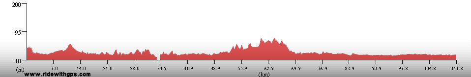
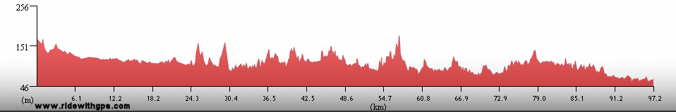
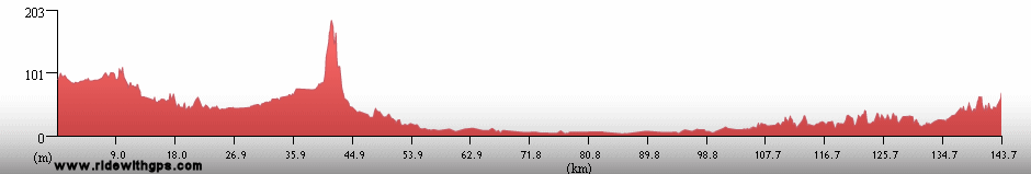
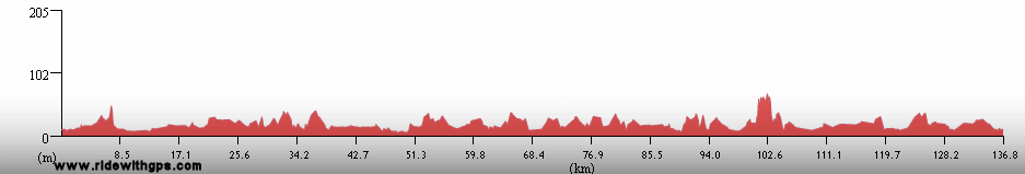
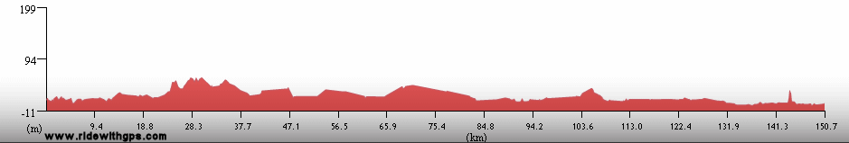
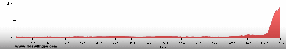
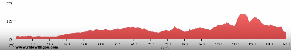
Stage 2 Actual Route

On this, and all other route maps, the blue lines represent travel by ship, red by airplane (Booo!), and green by bicycle. The actual route for Stage 2 was considerably different from my original plan. Laos was added, and consequently, my routes through Cambodia and Thailand were adjusted, the former lengthened and the latter shortened. India was completely redone, and unfortunately shortened somewhat, in order to better accomodate the sea transfer to Stage 3.
Singapore: Gateway to Asia
My time in the small city/country of Singapore was somewhat surprising, sometimes restful, and sometimes not. The city is famously urban, and famously tidy. Walking in the shadows of glass-walled office towers along crowded sidewalks seemed so far the fly-infested deserts of Western Australia, where I had been just a week earlier, that it took me a while to get my bearings. Unfortunately, I didn't have much leeway to do much bearing retrieval, as I had a number of chores that needed doing while in town. With the budget-bending costs of such a modern city straining my wallet, I also did not want to stay in town for an especially long time, and so it always seemed as if I was rushing around somewhere.
The overhaul of the bike that I couldn't do while at sea, was on tap, as was one of my least favorite tasks, obtaining visas that I would need along the way during the Stage. I had hoped to get three, for India, Bangladesh, and Myanmar while in town. Well, no go for India, as the embassy there required a week to process the application. Bangladesh was a bit of a pain as well, but I eventually received that one. Additionally, the crowd of dozens of men jam-packed into the small waiting room of the embassy's consular section gave me a preview of what traveling through that country would be like. Surprisingly, the Myanmar visa was the easiest of all to recieve, which turned out to be just about the only thing easy about traveling there.
After all of that, there was not much time left for exploring the city. I did my best, however, and managed to see a little of the city center, Chinatown, and the commercial area around Orchard Road, which was, a little surprisingly, decked out in Christmas lights and decorations. Before long the day to depart finally arrived, and I was happy to get back on the bike again, but a little worried since the city seemed quite bike-unfriendly to me. Fortunately, I left on a Sunday morning, as early as possible, and it was not a very big deal to ride the 35, or so, kilometers through the city to the Johor Causeway, the gateway to Malaysia, and the real start of Stage 2.
Basically the same information in the post: ~HERE~

Singapore Harbor

A busy cafe street in Chinatown

A Singapore street scene

The Cavanagh Bridge at night
Malaysia: Back on the Bike Again
Malaysia marked the real start of the ride for Stage 2, and I knew before I even left home that conditions there might not be the best. The late autumn and winter months are the wet season on the Malay peninsula, and in some places it is truly wet indeed. There was no way to avoid that within the bounds of the rest of my schedule, and so I just had to deal with the rain. The east coast gets the most, so I stayed away from that area. The west coast is where most of the population lives, and I was completely surprised at how urban and motorized that part of the country was. The central part of the peninsula is quieter, and contains many palm oil and rubber plantations, but is also hilly, and has a rather indirect road network. To balance out weather, quiet roads, and interesting destinations, I spent some time on the west coast and some in the central region.
My favorite places included Melaka, an historic city on the west coast which was once the capital of a locally powerful sultanate and later the seat of Portuguese rule in the region. Also enjoyable was Taman Negara National Park, in the rainforest-covered highlands in the center of the peninsula, and its charming service village of Kuala Tahan. The northwestern coastal area had some nice riding, and I enjoyed the little fishing town of Kuala Kedah, where I had my first (and last) experience with the famously odiferous Durian fruit.
All in all, except for the wetness, Malaysia was one of the easiest locations of the tour with good food, frequent services, and consistently good roads. I would have liked to have seen more of the country, but drying out by moving on was very appealing as well.
A brief post to start the Stage: ~HERE~

Girls go shopping in Melaka

An impressive mosque

A butterfly in Taman Negara National Park

Rows of trees in a rubber plantation
Thailand: Land of Golden Temples
Thailand came next, though I visited that country on two separate occasions, separated by about a month. The first of those was mostly in the southern part of the country, riding up both the west and east coasts of the peninsular part of the country, then looping above and around the mega-city of Bangkok, and finally heading east towards Cambodia. I found Thailand to contain many friendly people, an interesting culture with an ornately decorated temple seemingly on every corner, and probably the tastiest cuisine of the tour so far. On the other hand, the country was only moderately less urban than Malaysia, and so there was heavy traffic in places, and the monsoon was still present for much of the time, essentially spoiling the visits to the beach I had hoped to make. Interesting places along the route were more cultural in scope than I expected and included the tsunami-hit resort of Phuket, which was largely back on its feet, and the nice town of Phetchaburri, which contained many fine temples and monasteries. Later on, when the blue skies had finally returned for good, a visit to the historic ruined capital city of Ayutthaya was a fascinating break, as was Khao Yai National Park, where I saw wild elephants for the first time.
The second section in Thailand was unfortunately much shorter than I originally planned. The reasons were the addition of Laos to the route, which took a lot longer than I'd expected, and an unpleasant deadline to transfer to the next country. I also had to deal with the lingering effects of some bad food I'd eaten some time before, which slowed me down a bit and made the section seem very rushed. I had planned to see much of the northeastern part of the country, but that had to be scrapped due to time constraints. Instead, I re-entered Thailand at Chiang Khong at the northern Thai-Lao frontier across the Mekong River, and then swung to the south for a while before ending at Chiang Mai. Despite the rush there were some nice riding conditions in the area, and also some interesting sights. The best was another ruined capital at Sukhothai, which was a great place to bike through. Overall, Thailand was a lot of fun, although it was the last place in the Asian stage where conditions were consistently good, however I didn’t realize that at the time.
Two posts with some items of interst are: ~HERE~

A monkey looks out over Prachaup Khiri Khan

Stupas in the ancient city of Ayutthaya

Ayutthaya

A Temple at a rural Wat on the southeastern coast

Traditianal dancers at the King's birthday celebration in Phetchaburi
Cambodia: Tragic Past, Beautiful Present
Cambodia was where the stage really took off for me. I really enjoyed just about every aspect of touring there. With the exception of the few moderately-large cities I went through, most of the country had a much more rural feel, which is always more to my liking. Food was usually pretty good, and the weather was constantly nice, though there was a little too much wind on a few days. The amazing cultural and historical aspects of the country were more enjoyable than I had expected going in, with interesting sites scattered about the entire landscape, the vibrant capital of Phnom Phen, and, of course, the fantastic complex of Khmer ruins at Angkor, one of the world's great places. The only drawback, in my mind, was several sections of dusty gravel and dirt roads, the first of many I'd encounter in Asia. These included a short section between Sisophon and Siem Reap, and a longer, harder section to the northern border. That was not enough of a problem to keep Cambodia from being one of my favorite places of the tour so far. Best of all was the wonderfully pleasant Cambodian people. I was completely taken aback by how happy and friendly everyone seemed, despite the incredible suffering they had endured for decades before. Learning the story of their tragic past saddened me quite a bit, but the way their society had already rebounded quickly reversed that feeling.
A post for the amazing land of Cambodia is: ~HERE~

The magnificent Angkor Wat

A stone figure on the Bayon Temple at Angkor

The Silver Pagoda in Phnom Phen

The Independence Monument in Phnom Phen

Kids at Oudong Mountain
Previous | Next
Main Index | Pre-Tour Index
Post-Tour Index | Articles Index
Slideshows
Stage 2 Log
For a description of terms and symbols look: ~HERE~
November 13, 02005
Singapore to Benut, Malaysia
Distance: 110 km
Terrain: Flat with a short section of moderate rolling
Max. Elevation: <300 m
Roads: Burkit Timah Rd., Woodlands Rd, Singapore-Johor Causeway, Hwy 1,
Hwy 5
Max. Temp: 34 °C
Weather: Mostly sunny, some light headwinds
Accommodation:

Comment: First day of
Stage 2!; Half day for border formalities and reacclimation; surprisingly congested in Malaysia
November 14
Benut to Kesang
Distance: 134 km
Terrain: Flat with a short section of moderate rolling
Max. Elevation: <300 m
Roads: Hwy 5
Max. Temp: 34 °C
Weather: Partly sunny, very humid, one brief shower at midday; light afternoon headwinds
Accommodation:
Comment: Felt a little sluggish after layoff and from humidity
November 15
Melaka
Distance: 35 km
Accommodation:

Comment: Short ride to a rest/sightseeing day in Melaka
November 16
Melaka to Simpang Pertang
Distance: 149 km
Terrain: Light to heavy rolling
Max. Elevation: <300 m
Roads: Hwy 142, Hwy 17, M2, M8, M13, N117, Hwy 9
Max. Temp: 30 °C
Weather: Cloudy with one big thunderstorm
Accommodation:
Comment: Did not get quite as far as hoped due to a couple wrong turns; had to wait out storm
November 17
Simpang Pertang to Raub
Distance: 139 km
Terrain: Light to heavy rolling, with 1 small climb
Max. Elevation: <300 m
Roads: Hwy 9, E8, Hwy 8
Max. Temp: 33 °C
Weather: Mostly to partly cloudy
Accommodation:
Comment: A fairly easy day; clouds threatened, but no rain
November 18
Raub to Jerantut
Distance: 106 km
Terrain: Light to heavy rolling, with a few small hills
Max. Elevation: <300 m
Roads: Hwy 8, Hwy 54
Max. Temp: 33 °C
Weather: Mostly to partly cloudy, heavy shower during boat transfer
Accommodation:
Comment: A pleasant but short day; Riverboat transfer to Kuala Tahan & Teman Negara N.P.
November 19
Kuala Tahan
Accommodation:
Comment: Sightseeing day at Taman Negara N.P.
November 20
Jerantut to Kuala Lipis
Distance: 63 km
Terrain: Heavy to moderate rolling
Max. Elevation: <300 m
Roads: C164
Max. Temp: 32 °C
Weather: Light morning rain, heavy thundershower in afternoon
Accommodation:
Comment: Half day due to transfer back from park and afternoon storm
November 21
Kuala Lipis to 30 km W. of Gua Musang
Distance: 153 km
Terrain: Heavy to moderate rolling
Max. Elevation: <300 m
Roads: Hwy 8, D30
Max. Temp: 29 °C
Weather: Cloudy; morning drizzle, 1 brief afternoon shower
Accommodation:
Comment: A reasonably good day; cooler due to clouds; some interesting karstic landscapes; saw a lot of monkeys
November 22
30 km W. of Gua Musang to Sungai Siput Utara
Distance: 157 km
Terrain: Hilly, 1000-m climb, 1200-m descent, then light rolling
Max. Elevation: 1480 m
Roads: D30, Hwy 54, Hwy 1
Max. Temp: 25 °C
Weather: Cloudy; occasional light rain/drizzle/mist throughout day
Accommodation:
Comment: A somewhat larger climb than expected; pleasantly light traffic in mountains, heavy congestion around Ipoh and north
November 23
Sungai Siput Utara to Terap
Distance: 154 km
Terrain: Flat to light rolling
Max. Elevation: <300 m
Roads: Hwy 1, Hwy 147, A7, K7, Hwy 136
Max. Temp: 26 °C
Weather: Cloudy; occasional drizzle/light rain through morning
Accommodation:
Comment: A damp, but fairly easy day
November 24
Terap to Kuala Kedah
Distance: 161 km
Terrain: Light to moderate rolling, then flat

Max. Elevation: <300 m
Roads: Hwy 136, K812, Hwy 147, Hwy 36, Hwy 167, Hwy 1, K1
Max. Temp: 25 °C
Weather: Mostly cloudy; brief period of drizzle in afternoon; mild to light afternoon tail/crosswinds
Accommodation:
Comment: A fairly easy day
November 25
Kuala Kedah to Langu, Thailand
Distance: 166 km
Terrain: Flat, then light to moderate rolling with 1 small climb
Max. Elevation: 290 m
Roads: Hwy 7, R13, Hwy 406 (Thai), Hwy 4137,
Hwy 416
Max. Temp: 28 °C
Weather: Cloudy, with a couple brief showers
Accommodation:
Comment: Route was a little longer than expected
November 26
Langu to Si Kao
Distance: 175 km
Terrain: Flat to moderate rolling
Max. Elevation: <300 m
Roads: Hwy 4, Hwy 419, Hwy 4046
Max. Temp: 29 °C
Weather: Cloudy, rain in late afternoon
Accommodation:
Comment: A long day, easy until rain started
November 27
Si Kao to Ao Nang
Distance: 113 km
Terrain: Light to moderate rolling
Max. Elevation: <300 m
Roads: Hwy 4046, Hwy 4
Max. Temp: 31 °C
Weather: Partly to mostly sunny; one afternoon shower
Accommodation:
Comment: Half day for ferry transfer to Phuket island
November 28
Phuket
Accommodation:
Comment: Rest/chores day in Phuket
November 29
Phuket
Accommodation:
Comment: Rest/sightseeing day in Phuket
November 30
Phuket to Takuapa
Distance: 141 km
Terrain: Flat to light rolling
Max. Elevation: <300 m
Roads: Hwy 402, Hwy 4
Max. Temp: 33 °C
Weather: Partly sunny, then cloudy; light head/crosswinds; big evening thunderstorm
Accommodation:
Comment: Easy day, but did not get quite as far as planned due to storm
December 1
Takuapa to Ranong
Distance: 165 km
Terrain: Light to moderate rolling
Max. Elevation: <300 m
Roads: Hwy 4
Max. Temp: 28 °C
Weather: Cloudy, one brief period of drizzle
Accommodation:
Comment: A fairly dreary day
December 2
Ranong to Pa Thiu
Distance: 167 km
Terrain: Light to heavy rolling
Max. Elevation: <300
Roads: Hwy 4, Hwy 317, Hwy 3180, Hwy 3201
Max. Temp: 32 °C
Weather: Morning and evening showers, otherwise mostly cloudy
Accommodation:
Comment: A relatively easy day
December 3
Pa Thiu to Bang Saphan
Distance: 91 km
Terrain: Light to moderate rolling
Max. Elevation: <300 m
Roads: Hwy 3201, Hwy 4004, Hwy 4044, Hwy 3274
Max. Temp: 31 °C
Weather: Partly cloudy; afternoon showers
Accommodation:
Comment: Half day for a rest break in Bang Saphan; some nice, relatively quiet, coastal roads
December 4
Bang Saphan to Ban Khung Tanot
Distance: 156 km
Terrain: Flat, with one section of light rolling
Max. Elevation: <300 m
Roads: Bang Nong Rawaeng Rd., Hwy 3423, Hwy 4, Rd. 1026
Max. Temp: 30 °C
Weather: Periods of rain through late afternoon
Accommodation:
Comment: A wet but fairly easy day, too much traffic on the main highway
December 5
Ban Khung Tanot to Phetchaburi
Distance: 130 km
Terrain: Flat
Max. Elevation: <300
Roads: Rd. 1026, Rd. 1020, Hwy 4
Max. Temp: 26 °C
Weather: Periods of rain through late afternoon
Accommodation:
Comment: Slow day due to weather and tire problems
December 6
Phetchaburi
Accommodation:
Comment: Rest/sightseeing day in Phetchaburi
December 7
Phetchaburi to Kamphaeng Saen
Distance: 157 km
Terrain: Flat
Max. Elevation: <300 m
Roads: Hwy 4, Hwy 35, Hwy 325, Hwy 4, Hwy 321
Max. Temp: 28 °C
Weather: Mostly cloudy with a little sunshine at midday
Accommodation:
Comment: An easy day; first day without rain in a long time; visited Damnoen Saduak Floating Market
December 8
Kamphaeng Saen to Ayutthaya
Distance: 153 km
Terrain: Flat
Max. Elevation: <300 m
Roads: Hwy 321, Hwy 3021, Hwy 329, Hwy 3454, Hwy 3263
Max. Temp: 30 °C
Weather: Sunny (!); strong headwinds, diminishing during day
Accommodation:
Comment: A leisurely ride to a break in Ayutthaya; Sunshine!
December 9
Ayutthaya
Distance: 24 km
Accommodation:
Comment: Sightseeing Day in Ayutthaya
December 10
Ayutthaya
Distance: 21 km
Accommodation:
Comment: Repairs and sightseeing day in Ayutthaya
December 11
Ayutthaya to
Khao Yai N.P.
Distance: 150 km
Terrain: Flat
Max. Elevation: <300 m
Roads: Hwy 3063, Hwy 329, Hwy 33, Hwy 3077
Max. Temp: 33 °C
Weather: Mostly sunny; moderate crosswinds
Accommodation:
Comment: An easy and uneventfull day
December 12
Khao Yai N.P.
Distance: 80 km
Terrain: Mountainous, 700-m climb/descent
Max. Elevation: 820 m
Roads: Hwy 3077
Max. Temp: 26 °C
Weather: Mostly to partly cloudy; gusty winds, various directions
Accommodation:
Comment: Sightseeing ride into Khao Yai N.P.; saw many butterflies and some wild elephants
December 13
Khao Yai N.P. to Aranya Prathet
Distance: 180 km
Terrain: Flat to light rolling
Max. Elevation: <300 m
Roads: Hwy 3077, Hwy 33
Max. Temp: 31 °C
Weather: Sunny; moderate to very strong crosswinds
Accommodation:
Comment: Rode straight through to get close to border, includes extra 23 km due to nearly disastrous blunder
December 14
Aranya Prathet to Sisophon, Cambodia
Distance: 68 km
Terrain: Flat
Max. Elevation: <300 m
Roads: Hwy 33, Hwy 6 (Cam)
Max. Temp: 31 °C
Weather: Mostly cloudy to overcast; strong crosswinds
Accommodation:
Comment: Very late start due to banks/border procedures. Stopped in early Sisophon
December 15
Sisophon to Siem Reap
Distance: 108 km
Terrain: Flat

Max. Elevation: <300 m
Roads: Hyw 6 (1st 70 km dirt)
Max. Temp: 29 °C
Weather: Cloudy
Accommodation:
Comment: Half day over rough, dusty road to break in Siem Reap
December 16
Siem Reap
Distance: 42 km
Accommodation:
Comment: Sightseeing day at Angkor
December 17
Siem Reap
Distance: 97 km
Accommodation:
Comment: Sightseeing day at Angkor
December 18
Siem Reap to Kompong Thom
Distance: 158 km
Terrain: Flat
Max. Elevation: <300 m
Roads: Hwy 6
Max. Temp: 32 °C
Weather: Mostly sunny; occasional light crosswinds
Accommodation:
Comment: Very easy conditions, but felt a little slow
December 19
Kompong Thom to Phnom Phen
Distance: 177 km
Terrain: Flat
Max. Elevation: <300 m
Roads: Hwy 6
Max. Temp: 28 °C
Weather: Overcast
Accommodation:
Comment: A long, but fairly easy ride to a long break in Phnom Phen
December 20
Phnom Phen
Accommodation:
Comment: Rest Day in Phnom Phen
December 21
Phnom Phen
Accommodation:
Comment: Rest Day in Phnom Phen
December 22
Phnom Phen
Accommodation:
Comment: Rest Day in Phnom Phen; visited Killing Fields and Genocide Museum
December 23
Phnom Phen
Accommodation:
Comment: Rest Day in Phnom Phen; visited Wat Phnom and Royal Palace
December 24
Phnom Phen to Kompong Cham
Distance: 159 km
Terrain: Flat
Max. Elevation: <300 m
Roads: Hwy 5, Hwy 51, Prek Kdam Ferry, Hwy 6, Hwy 7
Max. Temp: 28 °C
Weather: Partly sunny, cloudy by afternoon; mild to light winds, various directions
Accommodation:
Comment: A fairly easy day after long break; visited Oudong mountain stupas
December 25
Kompong Cham to Kratie
Distance: 137 km
Terrain: Flat to light rolling
Max. Elevation: <300 m
Roads: Hwy 7, Chhlong Rd (95 km dirt)
Max. Temp: 28 °C
Weather: Partly sunny
Accommodation:
Comment: Reasonable day, considering long stretch on dirt
December 26
Kratie to Stung Treng
Distance: 148 km
Terrain: Flat to light rolling
Max. Elevation: 430 m
Roads: Hwy 7 (35 km paved, 110 km dirt)
Max. Temp: 32 °C
Weather: Partly sunny, to mostly cloudy; moderate headwinds through morning
Accommodation:
Comment: Very dusty, tiring day; saw Irrawady Dolphins in Mekong River
Continued on Next Page
Index | Next Page
Pre-Tour Stage 1 Stage 2 Stage 3 Stage 4 Stage 5 |