
Stage 5: A Bridge to Home
The bittersweet beginning of the end
The Tour Reports section of the site now contains the posts that I sent to the Phred Touring List (now on Google Groups) during the Tour. Those from the early days of the Tour were rather thin, while later on, for some of the more unique countries, they contain much more thorough accounts of the ride, and an occasional amusing anecdote. Towards the end of the Tour, however, I frequently couldn't keep up with the chore of sending posts on time, so the last several were written after the Tour was complete. Look for links to the posts at the end of the short descriptions beginning below.
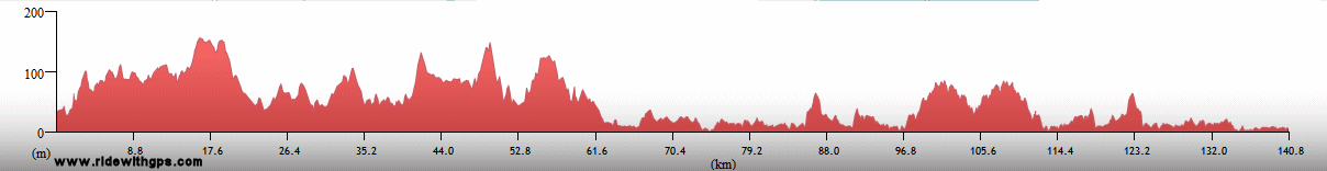
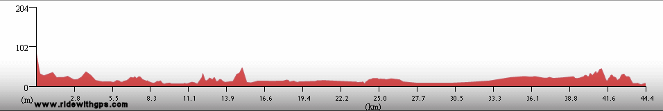
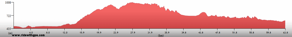
Stage 5 Actual Route

On this, and all other route maps, the blue lines represent travel by ship, red by airplane (Booo!), and green by bicycle.
Panama: Just Cross the Canal
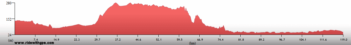
Panama, the first of six small nations along my route in Central America, had always been my planned starting point for Stage 5. However, once Stage 4 ran long, both in terms of time and expenses, I was not entirely sure whether there would even be a Stage 5. Of course, I eventually decided to throw all thoughts of practicality aside, and made my way to Panama City, the Stage's starting location. My stay in Panama was dominated by a week off for preparations, errands, and rest in the capital, and then by rather short rides in the regions around the famous canal, both on the Pacific and Caribbean sides. Once crossing the canal, via the Bridge of the Americas the rest of the route was rather predictable, namely across the western half of the country mostly using the rather unappealing Panamericana Highway.
One post for 6 small countries is: ~HERE~

Panama City: Starting point of Stage 5

A ship entering the Panama Canal

A Howler Monkey in the trees

The Panama Canal at Gamboa

Castillo San Lorenzo, on the Caribbean Coast

Playa Santa Clara, on the Pacific Coast
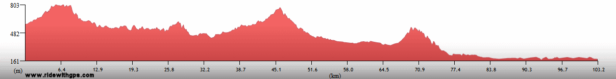
Costa Rica: Just Avoid the Hills
While there are several interesting things to see in Costa Rica, for scheduling reasons I confined my route to the mild terrain of the Pacific coast. Though there were no major attractions along the way in that area, the conditions were generally good, and I managed to include some time relaxing on the beach in locations like Dominical and Jaco. To add a little variation to the plan, I changed my route slightly, and crossed over to the Nicoya Peninsula for my final days in the country. That proved to be a nice choice as the riding conditions there were among the best in the region.

A Crocodile in a river

Sunset at Playa Jaco

A Turquoise-Browed Motmot
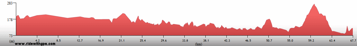
Nicaragua: Just Enjoy the Quiet
Nicaragua was probably my favorite of the Central American countries, thanks in large part to the generally quieter nature of its towns and cities, caused by its years of conflict and isolation during the previous century. I found that traffic was much less of a problem there, compared to other countries in the region, yet facilities were adequate almost everywhere, certainly a good combination. Unfortunately, it was not really possible to stay for a very long time, as almost all of the nation's towns and transport routes are located in a small area in the western part of the country. I entered in its southwest corner, rode north along the shore of the attractive and large Lago Nicaragua, sliding through just the outer edges of the capital, Managua, and then finished with a section through the northwest corner towards the border with Honduras. Highlights were the charming and relaxed colonial town of Granada, and the similarly historic, though more politically active town of Leon. Another plus was, in a first for the Tour, the ability to actually see the string of volcanoes located there thanks to cloud-free skies.

Lago Nicaragua and Volcan Concepcion

Evening in the colonial town of Granada

Granada Cathedral

Volcans Mombotombo and Mombotombito

Sandino squashing Uncle Sam in Leon

Leon Cathedral

Virgen Procession in Chinandega
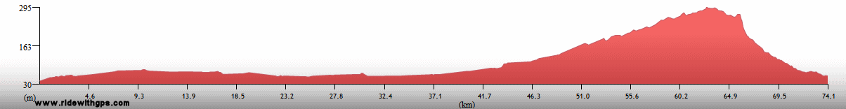
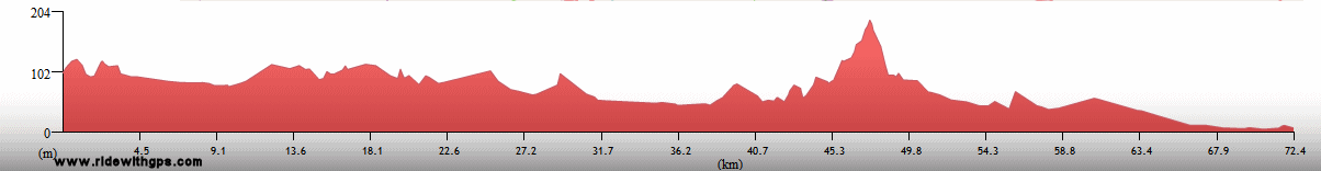
Honduras: Just Survive the Heat
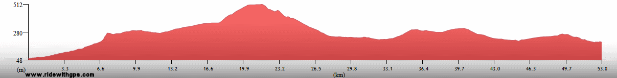
Honduras was where I left the vicinity of the Isthmus's west coast for the rougher terrain of the central mountains. That meant a relatively short climb, but one that was significantly tiring thanks to the already-high temperatures of the Central American spring. A short break in the capital, Tegucigalpa, followed, and then came a very slow ride to the north and west, though the still-hot and now-smoky highlands. The goal of that section was the Stage's first major destination, the ruins of the Mayan city of Copan, the first of nine ruins sites I would see during subsequent weeks. That site, by itself, made a visit to the country, and the exhausting riding that it entailed, worthwhile, and provided an excellent introduction to the Mayan region.

Iglesia los Dolores in Tegucigalpa

Decorations on the Presidential Palace, Tegucigalpa

A market street in Comayagua

Oropendola Nests

Ruins of the Mayan city at Copan

Ball Court at Copan

Mayan Hieroglyphs on a Stela at Copan

Museum of Mayan Sculpture at Copan
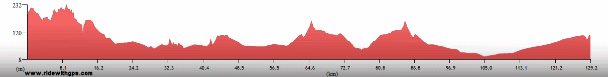
Guatemala: Just Climb the Pyramids
Guatemala was another case where my route forced me to miss some of the more interesting places in the country. However, while that was unfortunate, I eventually reached one of the best destinations of the Stage. Once again, due to time constraints, I limited myself to the lowlands of the country, located in its south and east. My entry point was at the southern border with Honduras, just west of Copan, from there I turned to the east, on a highway destined for the Caribbean coast. Along the way, was the first attraction I visited the country, the small Mayan site of Quirigua, with its intricately carved boulders and stelae. Before reaching the coast, however, I turned north again and soon stopped at the little town of Flores, loctated on a island in Lago Peten Itza. Not far beyond, was the huge Mayan city of Tikal, which boasted the greatest number of large pyramids I have ever seen in a single location, which were even more impressive thanks to the large parcel of primary forest that surrounds the site.

Carved Stone Altar at the Mayan ruins at Quirigua

Rio Dulce Pueblo

Corpus Cristi Procession in Flores

Temple 1 at the ruins of the Mayan city at Tikal

A Keel-Billed Toucan

Temple 5 at Tikal

Temples of Tikal reach above the forest canopy
Previous | Next
Main Index | Pre-Tour Index
Post-Tour Index | Articles Index
Slideshows
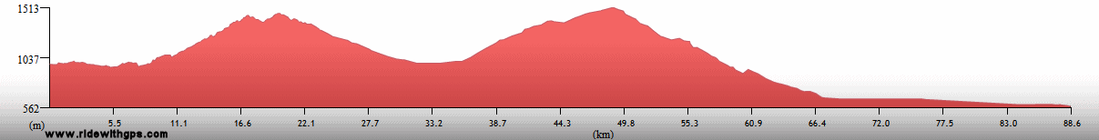
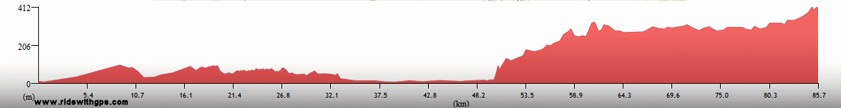
Stage 5 Log
For a description of terms and symbols look: ~HERE~
April 15, 02008
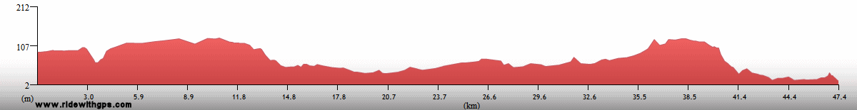
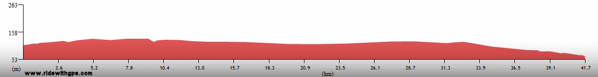
Panama City, Panama to Gamboa
Distance: 40 km
Terrain: Flat to light rolling

Max. Elevation: <300 m
Roads: Balboa-Gamboa Rd.
Max. Temp: 32 °C
Weather: Mostly sunny; moderate to strong headwinds
Accommodation:

Comment: Short first day for Stage 5!; visited Panama Canal at Miraflores locks
April 16
Gamboa
Distance: 15 km
Accommodation:
Comment: Sightseeing day at Gamboa; visited forest canopy tram, and Soberania National Park
April 17
Gamboa to Colon
Distance: 146 km
Terrain: Moderate to light rolling
Max. Elevation: <300 m
Roads: Gamboa Rd, Madden Hwy, Transistmia Hwy (mostly narrow, rough, heavy traffic), Gatun Locks Rd., San Lorenzo Park Rd.
Max. Temp: 31 °C
Weather: Partly cloudy, occasional moderate headwinds, one very brief period of light drizzle
Accommodation:
Comment: Distance includes additional 70 km to visit Castillo de San Lorenzo; mixed conditions, nice within national parks, but very unpleasant on transistmica Hwy
April 18
Colon
Accommodation:
Comment: Afternoon rail transfer back to Panama City to avoid duplicate ride on poor road
April 19
Panama City to La Chorrera
Distance: 44 km
Terrain: Moderate rolling
Max. Elevation: <300 m
Roads: Local Rds., C-1
Max. Temp: 31 °C
Weather: Mostly sunny; occasional moderate crosswinds
Accommodation:
Comment: Unpleasant conditions leaving city, and felt very sluggish; planned on a full day, but stopped very early
April 20
La Chorrera to Playa Santa Clara
Distance: 83 km
Terrain: Moderate to light rolling, with one small climb/descent
Max. Elevation: <300 m
Roads: C-1
Max. Temp: 34 °C
Weather: Partly sunny; light tailwinds
Accommodation:
Comment: Another day much shorter than planned; decided to stop for only easy beach access.
April 21
Playa Santa Clara to Santiago
Distance: 137 km
Terrain: Light to moderate rolling
Max. Elevation: <300 m
Roads: C-1
Max. Temp: 35 °C
Weather: Partly sunny; moderate to light tail/crosswinds, headwinds during section when road curved northwards
Accommodation:
Comment: Reasonable conditions for most of route, but a very uninteresting day
April 22
Santiago to Sona
Distance: 76 km
Terrain: Light to moderate rolling
Max. Elevation: <300 m
Roads: C-1, Old Panamericana Hwy (somewhat potholed)
Max. Temp: 38 °C
Weather: Mostly sunny, increasing clouds in afternoon; occasional mild tailwinds
Accommodation:
Comment: Another unplanned half day; stopped due to heat; nice to leave main highway
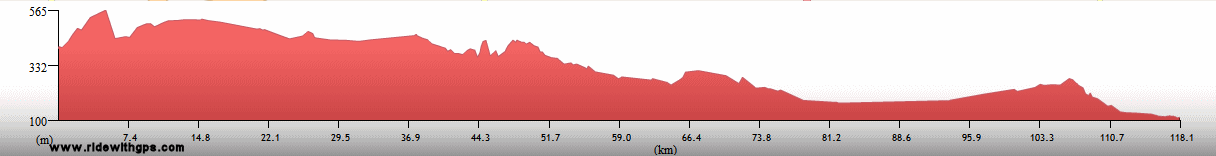
April 23
Sona to Las Lajas
Distance: 94 km
Terrain: Heavy to light rolling, one small climb/descent
Max. Elevation: <300 m
Roads: Old Panamericana Hwy (20 km new pavement, then short alternating sections of old pavement and loose gravel)
Max. Temp: 33 °C
Weather: Early clouds, then mostly sunny; occasional mild winds, various directions
Accommodation:
Comment: Slow, short day mostly due to road condition; actual distance slightly longer than map indicated
April 24
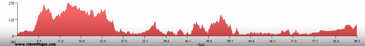
Las Lajas to Paso Canoas, Costa Rica
Distance: 132 km
Terrain: Light rolling; one very gradual small climb/descent; moderate rolling
Max. Elevation: <300 m
Roads: C-1
Max. Temp: 37 °C
Weather: Mostly sunny, increasing clouds in afternoon; mild headwinds in afternoon
Accommodation:
Comment: A reasonable, though still hot, day; fairly quick border formalities; could have gone a little further, but not really necessary
April 25
Paso Canoas to Dominical
Distance: 159 km
Terrain: Light to moderate rolling; light to heavy rolling
Max. Elevation: <300 m
Roads: CR-2, CR-34
Max. Temp: 36 °C
Weather: Mostly sunny, partly cloudy in afternoon with brief period of sporadic light showers
Accommodation:
Comment: A generally nice day, though still very hot; nice road in afternoon; pleasant sunset swim at Dominical Beach
April 26
Dominical to Quepos
Distance: 46 km
Terrain: Flat
Max. Elevation: <300 m
Roads: CR-34 (poor dirt/rocks, final 4 km paved)
Max. Temp: 37 °C
Weather: Mostly sunny, partly cloudy in afternoon
Accommodation:
Comment: Unexpected poor road very slow; had to stop early to replace rear derailer broken by rock
April 27
Quepos to Jaco
Distance: 70 km
Terrain: Flat; flat to light rolling
Max. Elevation: <300 m
Roads: CR-34
Max. Temp: 37 °C
Weather: Partly sunny; light to mild tail/crosswinds
Accommodation:
Comment: An easy half day to rest break at Playa Jaco
April 28-29
Jaco
Accommodation:
Comment: Rest days in Playa Jaco
April 30
Jaco to Playa Naranjo
Distance: 85 km
Terrain: Flat to light rolling, with 2 small climbs/descents; light rolling to flat
Max. Elevation: <300 m
Roads: CR-34, CR-27, CR-17, Puntarenas-Naranjo Ferry
Max. Temp: 36 °C
Weather: Partly sunny, mild to light cross/headwinds in afternoon; light shower just before sunset
Accommodation:
Comment: Felt very sluggish, though generally pleasant half day to accomodate ferry crossing of Gulf of Nicoya; short extra distance looking for place to stay
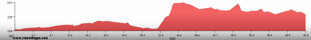
May 1
Playa Naranjo to Liberia
Distance: 149 km
Terrain: Flat to light rolling; light rolling with small gain/decline; flat; one small climb
Max. Elevation: <300 m
Roads: CR-21 (10 km fair gravel near start; last 30 km surprisingly heavy traffic)
Max. Temp: 35 °C
Weather: Mostly cloudy/overcast
Accommodation:
Comment: Felt tired again, but an otherwise reasonable day
May 2
Liberia to Playa San Jorge, Nicaragua
Distance: 122 km
Terrain: Flat to light rolling; one small climb; light rolling; one small rolling descent; flat to light rolling
Max. Elevation: <300 m
Roads: CR-1, NIC-2 (CA-2) (Nic.)
Max. Temp: 33 °C
Weather: Sunny; light to moderate crosswinds through morning
Accommodation:
Comment: A generally nice, though short day; passed through Guanacaste Conservation Area; easy border exit in C.R, slow entry into Nic.; excellent conditions along Lake Nicaragua shore, except for swarms of tiny flies
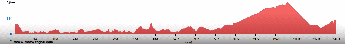
May 3
Playa San Jorge to Granada
Distance: 74 km
Terrain: Flat, one small climb/descent
Max. Elevation: <300 m
Roads: NIC-2, NIC-4 (1st 10 km bumpy)
Max. Temp: 33 °C
Weather: Partly sunny; moderate cross- to cross/tailwinds through morning
Accommodation:
Comment: An easy half day to break in Granada
May 4
Granada
Accommodation:
Comment: Rest day in Granada
May 5
Granada to Managua
Distance: 60 km
Terrain: 450-m climb; light rolling, with 2 small descents
Max. Elevation: 480 m
Roads: NIC-4, NIC-115, NIC-4
Max. Temp: 33 °C
Weather: Mostly sunny
Accommodation:
Comment: Short, easy half day; did not really want to stop in Managua, but distance to next site too long for 1 day, and no other good locations available
May 6
Managua to Leon
Distance: 128 km
Terrain: Flat to light rolling
Max. Elevation: <300 m
Roads: NIC-28, Leon Viejo Rd. (good paving stones), NIC-12
Max. Temp: 38 °C
Weather: Mostly sunny; moderate tailwinds
Accommodation:
Comment: A generally easy day, despite heat and a few annoying mechanical problems; inludes 30 km side trip to visit ruins of Leon Viejo
May 7
Leon
Accommodation:
Comment: Rest/errands day in Leon
May 8
Leon to Chinadega
Distance: 42 km
Terrain: Flat
Max. Elevation: <300 m
Roads: NIC-12
Max. Temp: 35 °C
Weather: Sunny; occasional light crosswinds
Accommodation:
Comment: Intended to ride a full day but, despite easy conditions, stopped after a short half day; stop here made for better spaced days ahead
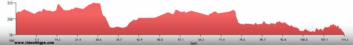
May 9
Chinadega to Choluteca, Honduras
Distance: 125 km
Terrain: Flat, with slight gain; moderate rolling; light rolling to flat
Max. Elevation: <300 m
Roads: NIC-24 (CA-3) (last 14 km with numerous rough patches); CA-3 (Hond.), CA-5
Max. Temp: 38 °C
Weather: Mostly sunny; occasional mild to light wind, various directions
Accommodation:
Comment: Another scorching day; fairly quick border formalities
May 10
Choluteca to Sabanagrande
Distance: 105 km
Terrain: Light to moderate rolling; 835-m climb; moderate to heavy rolling
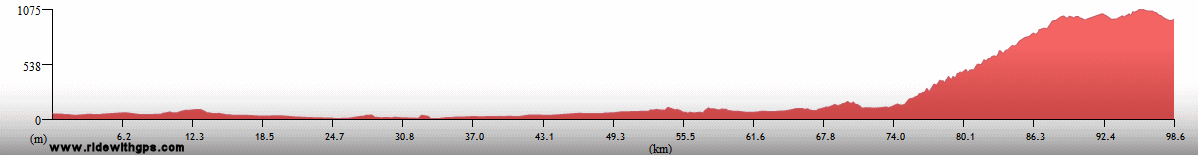
Max. Elevation: 1,070 m
Roads: CA-5
Max. Temp: 39 °C
Weather: Sunny, with increasing haze; thunderstorms in area before sunset, but none on route
Accommodation:

Comment: Distance to capital relatively short, but decided to break into two days; would not have had time to reach city in any case as heat slowed progress considerably, especially during big climb
May 11
Sabanagrande to Tegucigalpa
Distance: 48 km
Terrain: Heavy rolling; 470-m climb/descent; light rolling
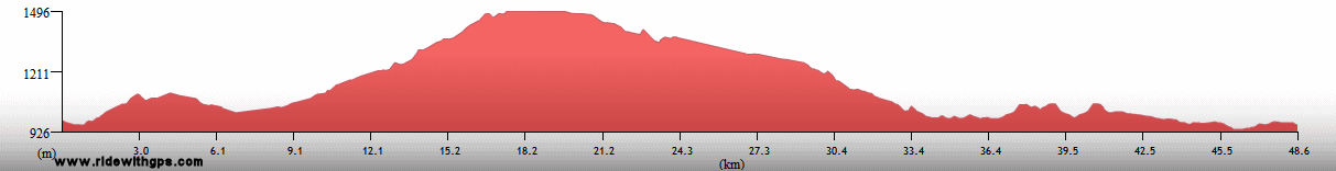
Max. Elevation: 1,470 m
Roads: CA-5
Max. Temp: 32 °C
Weather: Mostly sunny
Accommodation:
Comment: Short half day to break in Tegucigalpa
May 12-13
Tegucigalpa
Accommodation:
Comment: Rest days in Tegucigalpa
May 14
Tegucigalpa to Comayagua
Distance: 93 km
Terrain: 510-m climb/descent; 490-m climb; 810-m descent, broken by 2 short climbs
Max. Elevation: 1,490 m
Roads: CA-5
Max. Temp: 37 °C
Weather: Sunny/hazy; mild to light tailwinds, moderate crosswinds in afternoon after big descent
Accommodation:
Comment: Long but relaxed-paced half day; stopped to better space following days; surprisingly light traffic until inexplicable jam with many trucks at end of big descent
May 15
Comayagua to Santa Barbara
Distance: 124 km
Terrain: Light rolling; 550-m climb; 530-m descent, broken by small climb; hilly; 300-m descent; light to moderate rolling
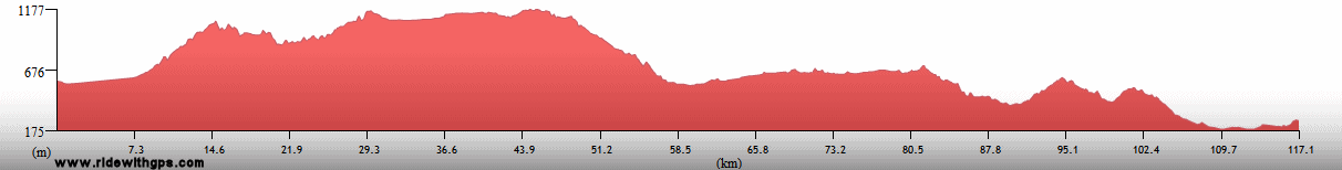
Max. Elevation: 1,200 m
Roads: CA-5 (heavy traffic), CA-20
Max. Temp: 36 °C
Weather: Sunny/hazy
Accommodation:
Comment: A short, but rather tiring day; much nicer after leaving main highway
May 16
Santa Barbara to La Flecha
Distance: 94 km
Terrain: Moderate rolling; 515-m climb; 400-m descent; heavy to moderate rolling
Max. Elevation: 715 m
Roads: CA-20, CA-4 (moderate traffic)
Max. Temp: 39 °C
Weather: Sunny/hazy
Accommodation:
Comment: Planned to go considerably farther, but stopped early due to heat in village not marked on map
May 17
La Flecha to La Entrada
Distance: 43 km
Terrain: Moderate to light rolling, with one small climb
Max. Elevation: 550 m
Roads: CA-4
Max. Temp: 36 °C
Weather: Sunny/hazy
Accommodation:
Comment: Very short half day due to heat and tiredness
May 18
La Entrada to Copan Ruinas
Distance: 64 km
Terrain: Light rolling; 520-m climb, broken by short descent; small descent; light to heavy rolling
Max. Elevation: 1,070 m
Roads: CA-11
Max. Temp: 35 °C
Weather: Partly sunny; a little cooler after summit of climb; thunderstorm in afternoon, after ride over
Accommodation:
Comment: Fairly pleasant half day to break at Copan; visited municipal museum
May 19
Copan Ruinas
Accommodation:
Comment: Sightseeing day at Copan Mayan Ruins
May 20
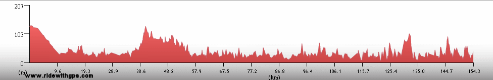
Copan Ruinas to Rio Hondo, Guatemala
Distance: 104 km
Terrain: One small climb/descent; moderate rolling; one small climb; 300-m descent; light to moderate rolling
Max. Elevation: 900 m
Roads: CA-11 (Hond./Guat.), CA-10
Max. Temp: 39 °C
Weather: Sunny/hazy
Accommodation:
Comment: Short day due to spacing to next stop and heat; easy border procedures
May 21
Rio Hondo to Los Amates
Distance: 87 km
Terrain: Light to moderate rolling, one small climb/descent
Max. Elevation: <300 m
Roads: CA-9
Max. Temp: 38 °C
Weather: Cloudy, becoming sunny/hazy by afternoon
Accommodation:
Comment: Half day for sightseeing at Maya ruins at Quirigua; distance includes extra 18 km to site and return
May 22
Los Amates to Rio Dulce
Distance: 77 km
Terrain: Flat to light rolling; small climb; light rolling
Max. Elevation: <300 m
Roads: CA-9, CA-13
Max. Temp: 37 °C
Weather: Partly cloudy/hazy
Accommodation:
Comment: Another half day, easy but hot; stopped to take care of errand and escape heat
May 23
Rio Dulce to San Luis
Distance: 85 km
Terrain: Light to heavy rolling; one small climb; light rolling, with gradual gain
Max. Elevation: 386 m
Roads: CA-13
Max. Temp: 39 °C
Weather: Sunny/hazy
Accommodation:
Comment: An exhausting half day, due to heat and terrain tougher than expected; planned to go slightly fartger, but stopped at a nice place to cool off
May 24
San Luis to Flores
Distance: 128 km
Terrain: One small climb; heavy to light rolling with gradual descent
Max. Elevation: 550 m
Roads: CA-13
Max. Temp: 37 °C
Weather: Sunny/hazy through morning; thundershowers with much lightning in afternoon, period of heavy rain during ride
Accommodation:
Comment: A mixed day; hot and tiring at first, then surprisingly pleasant as rain lowered temperature by 13C; 1st rain of Stage, and enjoyed getting wet
May 25
Flores
Accommodation:
Comment: Rest day in Flores
May 26
Flores to Tikal National Park
Distance: 68 km
Terrain: Light to moderate rolling, with one small climb
Max. Elevation: 385 m
Roads: CA-13, CA-13 (Tikal Park Rd.)
Max. Temp: 35 °C
Weather: Cloudy through morning, then partly to mostly sunny
Accommodation:
Comment: Easy and leisurely half day to break at tikal; visited site museums
May 27
Tikal National Park
Accommodation:
Comment: Excellent sightseing day at Maya city of Tikal; also saw some great birds
May 28
Tikal National Park to Cayo, Belize
Distance: 117 km
Terrain: Moderate rolling, one small descent, heavy to moderate rolling
Max. Elevation: 385 m
Roads: CA-13 (Tikal Park Rd.), RD-13 (several potholed sections, final 23 km fair to good dirt/gravel, but very dusty), Western Hwy. (Blz.)
Max. Temp: 35 °C
Weather: Mostly to partly sunny; storm in area in afternoon, but no rain on route; moderate to mild headwinds in afternoon
Accommodation:
Comment: Short, but tedious and tiring day; terrain a little tougher than expected, and did not enjoy dusty section of road; reasonable border procedures
Continued on next page
Index | Next Page
Pre-Tour
Stage 1
Stage 2
Stage 3
Stage 4
|