
Stage 2: The Top & Bottom
A time to climb, forced to freeze, and a season to sweat
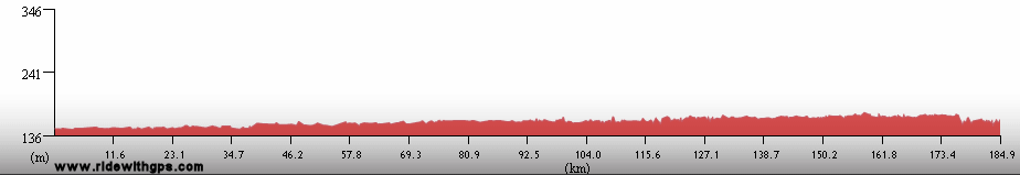
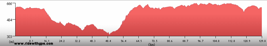
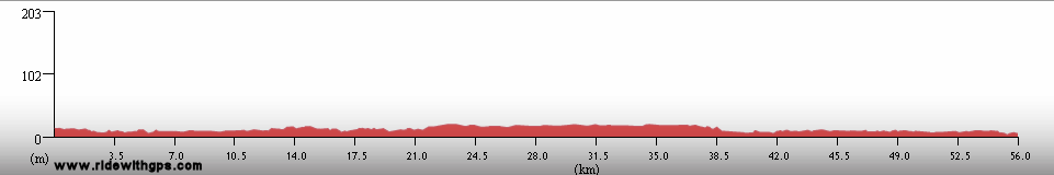
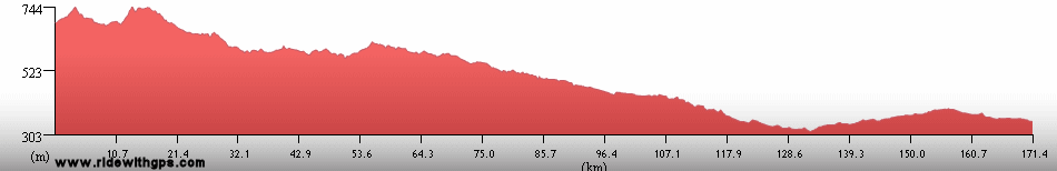
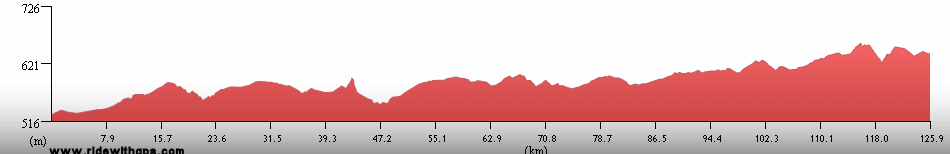
Stage 2 Actual Route
On this, and all other route maps, the blue lines represent travel by ship, red by airplane (Booo!), and green by bicycle.
Nepal: Beauty and Revolution
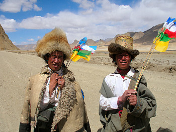
Another, more well known, Himalayan Kingdom came next, the classic travel destination of Nepal. I visited there on three occasions, each with a different feel and a different outcome. The first route was an easy ride through the eastern part of the southern plains, known as the "Tarai," starting at the eastern border with India at Kakharbitta, and moving west, entering India again at Sonauli. The conditions were quite good, except perhaps for the food, which was much less appealing than in the rest of the country. The highlight of this section was a nice visit to Royal Chitwan National Park, where I saw wild rhinoceros for the first time.
The second visit was when most of the best rides, and sightseeing was to occur. However, for the first couple of days I was a little under the weather, and so didn't have a very easy time. For this section I re-entered Nepal at Sonauli, stopping briefly to visit the Buddha's birthplace at Lumbini, then rode north, up into the mountains, to the resort town of Pokhara, beneath the mighty Himalayan peak of Annapurna. Next, I turned to the east and towards the famous capital, Kathmandu. There were some great conditions along the was, with the oncoming Spring brightening the landscape. An pleasant stop along the way was the historic hill town of Ghorka. A brief stay in Kathmandu followed, just long enough to finalize my plans for Tibet, and then it was a pretty, and enjoyable ride to the border.
The final Section in Nepal was meant to be the shortest, simply a ride back from the Tibetan border, through Kathmandu, and then directly south to the Indian border. However, do to extraordinary circumstances, this was possibly the most fun and interesting section. The ride back from the border was normal enough, but as I approached the capital, I became entwined in massive street protests aimed and ending the King's rule. The next two days when I planned to rest and go sightseeing in wonderfully interesting Kathmandu, were a bit unproductive, due to the chaos gripping the city. Then just as I was about to continue on the King gave in, and democracy returned to the nation. It was a unique and somewhat exciting experience to be present at a major change in the country's governance.
Nepal was a welcome respite, on all three occasions, to the often mentally or physically stressful travel in the surrounding areas. The people and culture were pleasant and relaxed, and the environment was, of course, quite beautiful.
A post with some interesting happenings is: ~HERE~
Rhinos take a mud bath in Royal Chitwan National Park
Terraced mountains in the Lower Himalayas
The Kali Gandaki River
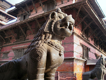
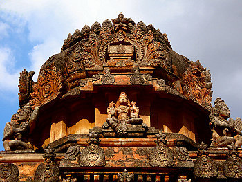
Durbar Square in Kathmandu
A huge pro-democracy protest in Kathmandu helped dethrone a King
Tibet: Legendary Land in the Sky
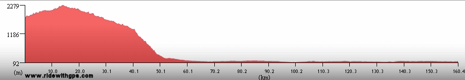
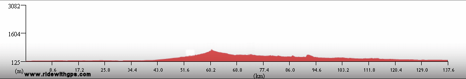
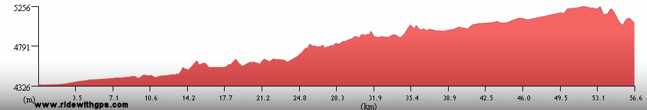
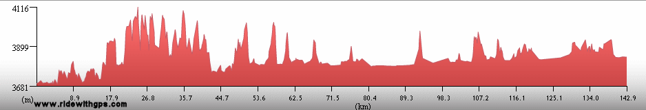
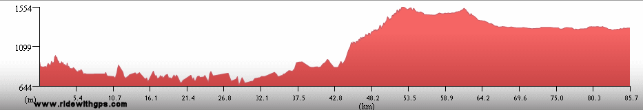
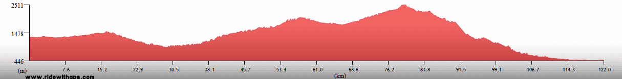
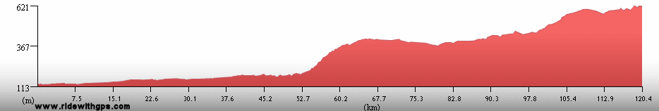
One of the Tour's "high points," in more ways than one, came next, an amazing visit to the highest country in the world, Tibet. I planned on doing a tour from Kathmandu to the capital, Lhasa, and back. Unfortunately, for political reasons, traveling on the route required an "official" guide and support, which again felt a little odd for me. As it turned out, the support was needed after all, however. The route followed a generally direct route along the Friendship Highway, which may have been friendly, but was often rocky, muddy, or sandy, and frequently slow going. Between the border and the second city of Tibet, Shigaste, were two passes in the vicinity of 5,200 meters of elevation, the higher one, Gyatso La, marking the high point of the tour. A turn off the main highway lead the route through the smaller, but very charming city of Gyantse, past the sacred lake of Yamdrok Yumtso, and over another 5,000 meter pass, before reaching the capital.
After the ride there, which often left me winded in the thin air, a long break in Lhasa, a city surrounded by beautiful mountains and jam-packed with spectacular cultural sites, was just what I needed. The fascinating Johkang Temple, the people-rich Barkhor Square, the Sera Monastery, and the completely compelling Potala Palace were the highlights. After that stay, we set off back to Nepal, generally on the same route, though we took a direct route back to Shigaste, following a good road through mostly flat valleys. At Shigaste, I made a difficult decision to transfer over the next section of rocky gravel road which also was experiencing horrendous headwinds. I was not pleased about that, but it may have been for the best as just before the border, and in the main Himalayan range, we were held up for two days thanks to a big snowstorm. Breaking through to the descent back to Nepal involved walking through the deep snow, pushing the heavy bike along, which was not really what I had in mind. Nevertheless, Tibet was one of the most fun, interesting, and personally rewarding sections of the tour.
A post befitting such a lofty place is: ~HERE~
Snowy peaks of the main Himalayan Range
Me at Gyatso La, the highest point of the Tour at 5,220 meters
Two pilgrims heading for Mount Kailash
Women from a rural village
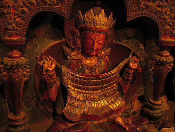
A figure in Palchoi Monastery in Gyantse
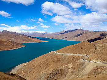
The sacred lake of Yamdrok Yumtso at 4,400 meters
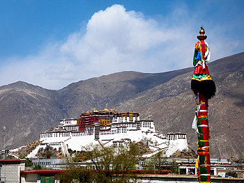
The famous Potala Palace in Lhasa
Sri Lanka: Island of 10,000 Lily Ponds
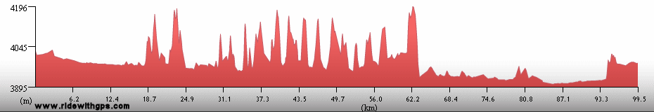
A visit to Sri Lanka was another that I was looking forward to, but another that was greatly affected by politics. Specifically, the 20-year long civil war between the Sinhalese government and the smaller Tamil population, which had been calm in recent years, but began to heat up as my visit neared, has disrupted many aspects of tourism on the island nation. The most notable disruption is the lack of any sea transport from nearby India. That caused me to make another annoying flight, and due to the changes in my transfer schedule to Stage 3, I had to fly from a city further to the north than I wanted.
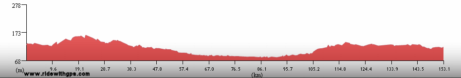
Once there, my routes was generally a clockwise circle of the island starting from the capital, Colombo. I first rode north, turning inland after a day or so, to visit the cluster of historic sites that includes the sacred city of Anaradhapura, the Golden Cave Temple at Dambulla, the rock fortress of Sigiriya, and the ruined city of Polonnaruwa. From there I headed to the east coast, where I hoped to relax on a quiet beach for a couple of days. However, due to my slow progress and the increasing conflict, which is centered on the east coast, I only had a few hours to do so. From there I took a route back to Colombo, which was more indirect than I wanted thanks to the conflict, passing through another sacred city, Kandy.
At that point, I was not feeling at full strength, my bike was even worse off, and the weather was beginning to turn bad. So, I shortened my ride by a day or two and rode straight back to Colombo. The rest there was appreciated and I was able to visit Galle, the other place I wanted to see, on a day trip by train. The political unrest certainly caused problems for my travel, however, the island was verdant and beautiful, the number of interesting sights on such a small island was impressive, and the facilities for touring were better than I had seen in months, so I had a rather good time.
Tales of beauty and annoyance in this post: ~HERE~
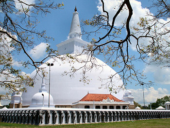
A Stupa in the scared city of Anuradhapura
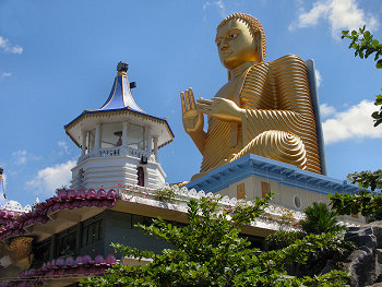
A giant Buddha at the entance to the Dambulla Golden Cave Temple
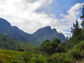
The central highlands on the way to Kandy
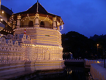
Dalada Maligawa in Kandy, the home of the Buddha's Tooth Relic
India: A Large Land of Contrasts
India, together with Bangladesh, Sri Lanka, and parts of Myanmar, Bhutan, and Nepal, were the only places on the Stage 2 route that were actually part of Gondwanaland, and so was one of the most important places on the route. Of course, being such a large nation, I was not able to see all of the places that I would have liked, despite entering the country on five separate occasions over four months. Additionally, the delays I encountered by lengthening the route in southeast Asia and by slow travel in the Himalayas required me to completely rework the route for the last two sections.
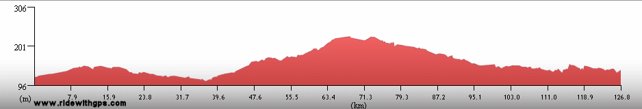
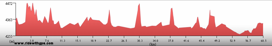
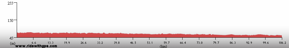
The first section was only one day long, a quick ride from Bangladesh to Bhutan, the only time I've ever ridden across such a large country in a single day. The second was longer and more varied, passing through the states of Assam and West Bengal. Those areas were often crowded and hectic once again and things did not quiet down until I ventured briefly up into the Himalayas once more. Specifically a quick visit to the famous tea-growing hill town of Darjeeling. While the climb up to the city, at 2,700 meters, was not the highest of the tour, it was certainly the steepest and most strenuous.
The next section was yet again longer, but completely flat for a change. Specifically, a round trip across the Gangatic Plain from the south-central Nepal-Indo border, to the famous city of Agra. The riding conditions there were mixed sometimes quiet, sometimes busy, with some good roads and some bad. So, when I reached Agra, I was quite ready to take a little time off to see the area's three famous destinations, Fatehpur Sikri, emperor Akbar's abandoned capital, Agra Fort, and, of course, the incomparable Taj Mahal. These places made the often stressful ride there completely worthwhile.
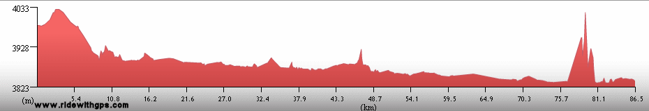
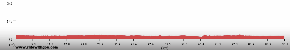
The fourth section came after my visit to Tibet, and the rapid cold-to-hot contrast proved to be a completely draining effect, especially since, while I was there, the "pre-monsoon heat" was already building.. This section was rerouted completely while the Stage was in progress. Instead of going down the center of the country, I took a more easterly course, in order to reach a place from where I could transfer to Sri Lanka. That turned out to be the east coast city of Bubaneshwar, the capital of Orissa state. In addition to that state, I rode through the states of Bihar, and Jaharkand. Once again there was a mix of conditions along the way, both easy and rough, and a somewhat varied landscape. The new route let me see two nice cultural sites, the famous Buddhist Mahabodi Temple at Bodh Gaya, and the Sun Temple at Konarka, both of which were very interesting.
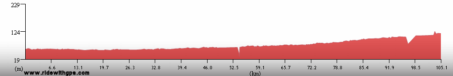
The final part of Stage 2 was also a new addition to the route, made to accommodate my sailing schedule. I now had to get from the east coast city of Chennai, to where I returned from Sri Lanka, to the west coast city of Mumbai, and did not have much time left to get there. On the bright side, the riding conditions in southern India were by far the best I encountered in India, with mostly good roads, usually good food, and a better choice of accommodations. On the other hand, the bike was really worn down, and eventually reached a point of uselessness with only a few days left to go. At the same time the summer monsoons decided to arrive 10 days ahead of their projected date. So I chose to end Stage 2 in the small, interesting state of Goa, and skip the last few days to Mumbai. That was slightly disappointing, as I then needed to transfer up to Mumbai, but Goa did prove to be a nice place to end. Along the way were some more nice cultural sites, the ruins at Mamallapuram, the impressive ruined city of Hampi, the ancient Temples at Pattadakal, and the old Portuguese Churches in Goa.
Overall, I was completely satisfied with my efforts in Stage 2. While it was often strenuous and tough, there were so many fascinating places and friendly people along the way that I will certainly remember those the most.
Four posts from this large country are: ~HERE~
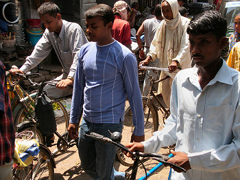
The roads are rather crowded sometimes
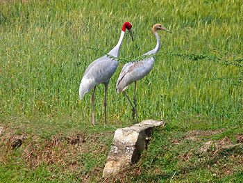
A pair of sarus Cranes
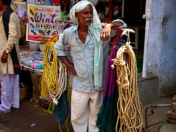
A man selling rope in Bodh Gaya
Krishna Temple in Hampi
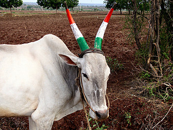
A patriotic cow
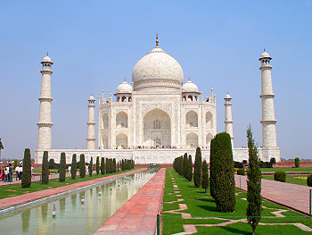
The incomparable Taj Mahal
A bonus Asian post; The Story of Steel is: ~HERE~
Dates and Distances
Start: November 13, 02005
Finish: May 30, 02006
Actual Distance: 17,587 km
Ride days: 121
Rest days: 78
Highest Point
5,220 meters: Gyatso La, Tibet
Previous | Next
Main Index | Pre-Tour Index
Post-Tour Index | Articles Index
Slideshows
Stage 2 Log
(continued)
For a description of terms and symbols look: ~HERE~
February 27, 02006
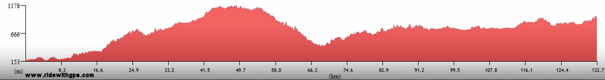
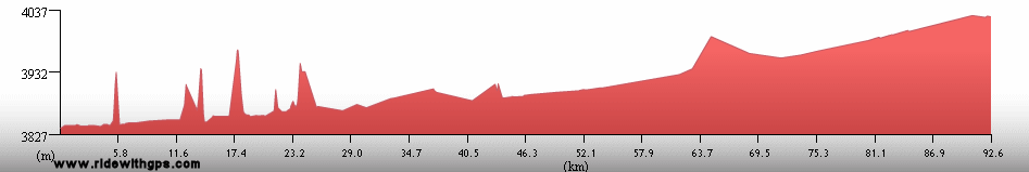
Samdrup Jongkhar to Guwahati, India
Distance: 104 km
Terrain: Flat
Max. Elevation: <300 m
Roads: Rangyia Rd., Hwy 31
Max. Temp: 32 °C
Weather: Overcast/haze
Accommodation:

Comment: A long half day after border formalities to rest break at Guwahati
February 28
Guwahati
Accommodation:
Comment: Rest day in Guwahati
March 1
Guwahati to Barpeta Road
Distance: 129 km
Terrain: Flat
Max. Elevation: <300 m
Roads: Hajo Rd (bad pavement/dirt-gravel), Hwy 31 (bumpy sections)
Max. Temp: 33 °C
Weather: Sunny; light afternoon headwinds
Accommodation:

Comment: A slow, tedious day due to bad roads and wind
March 2
Barpeta Road to Alipurduar
Distance: 174 km
Terrain: Flat
Max. Elevation: <300 m
Roads: Hwy 31, Alipur Rd.
Max. Temp: 34 °C
Weather: Sunny; light morning tailwinds/afternoon crosswinds
Accommodation:
Comment: Better conditions made an easier day; smaller number of bumpy sections of road; interrogated by the "drunkard policeman"
March 3
Alipurduar to Sevoke
Distance: 163 km
Terrain: Flat, then light rolling
Max. Elevation: <300 m
Roads: Hwy 31
Max. Temp: 31 °C
Weather: Sunny/hazy; Light afternoon cross/tailwinds
Accommodation:

Comment: Better roads, but still too many trucks; reasonable progress, but occasionally felt a little tired
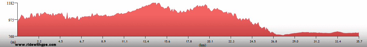
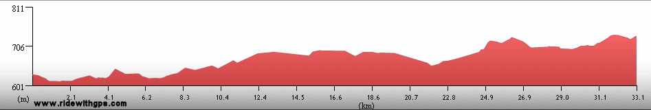
March 4
Sevoke to Darjeeling
Distance: 67 km
Terrain: Heavy rolling to hilly, then mountainous, 2,100-m climb
Max. Elevation: 2,280 m
Roads: Hwy 31, Old Hill Cart Rd.
Max. Temp: 26 °C
Weather: Mostly sunny, mostly cloudy by afternoon
Accommodation:
Comment: A tough long half day to rest break in Darjeeling, crazy steep grade for first 75% of big climb
March 5
Darjeeling
Accommodation:
Comment: Sightseeing day in Darjeeling; took a ride on the Darjeeling Himalayan Railway
March 6
Darjeeling to Damak, Nepal
Distance: 163 km
Terrain: Mountainous, 2,100-m descent, then flat
Max. Elevation: 2,280 m
Roads: Old Hill Cart Rd., Hwy 31, H1 (Nepal)
Max. Temp: 32 °C
Weather: Sunny, a little light crosswinds at midday
Accommodation:
Comment: A generally easy day; oftern bumpy, steep, narrow on big descent; extra ~18 km due to wrong turn near border; fairly quick border crossing; improved riding conditions once in Nepal
March 7
Damak to Lahan
Distance: 154 km
Terrain: Flat, then light rolling
Max. Elevation: 318 m
Roads: H1
Max. Temp: 34 °C
Weather: Sunny, moderate to strong head/crosswinds in afternoon
Accommodation:
Comment: An uneventful day, wind slowed progress a little
March 8
Lahan to Chandrinipurganj
Distance: 125 km
Terrain: Flat to light rolling
Max. Elevation: 430 m
Roads: H1
Max. Temp: 32 °C
Weather: Hazy
Accommodation:
Comment: Had to break for repairs, so did not get as far as hoped
March 9
Chandrinipurganj to Sauraha
Distance: 144 km
Terrain: Flat to light rolling, 540-m climb, then light to moderate rolling with gradual descent
Max. Elevation: 780 m
Roads: H1
Max. Temp: 32 °C
Weather: Overcast/haze
Accommodation:
Comment: A fairly easy day to a rest break st Suaraha
March 10
Sauraha
Accommodation:
Comment: Rest/sightseeing day in Sauraha; visited Royal Chitwan National Park; Rhinos!
March 11
Sauraha to Sunauli, India
Distance: 162 km
Terrain: Flat, with a few sections of light to moderate rolling, 370-m climb/descent
Max. Elevation: 850 m
Roads: H1, Siddhartha Hwy.
Max. Temp: 24 °C
Weather: Cloudy, a few periods of drizzle/light rain, and 1 big thunderstorm at midday
Accommodation:
Comment: An easy day, though started a little late and had to wait out storm; fairly quick crossing of border
March 12
Sunauli to Basti
Distance: 175 km
Terrain: Flat
Max. Elevation: 435 m
Roads: Hwy 29, Hwy 28
Max. Temp: 24 °C
Weather: Sunny
Accommodation:
Comment: A mixed day, good road and light traffic in morning , bumpy road and heavy traffic in afternoon
March 13
Basti to Lucknow
Distance: 200 km
Terrain: Flat
Max. Elevation: 470 m
Roads: Hwy 28
Max. Temp: 29 °C
Weather: Sunny
Accommodation:
Comment: A very long, tiring day; bumpy road with heavy traffic in morning, better road and somewhat less traffic in afternoon
March 14
Lucknow to Gursahaiganj
Distance: 157 km
Terrain: Flat
Max. Elevation: 518 m
Roads: Hwy 25, Sandila-Mallawan Rd., Hwy 21, Hwy 91
Max. Temp: 32 °C
Weather: Sunny; light afternoon cross/headwinds
Accommodation:
Comment: A fairly tedious day; some quite backroads, but bumpy in places
March 15
Gursahaiganj to Agra
Distance: 185 km
Terrain: Flat
Max. Elevation: 550 m
Roads: Hwy 91, Hwy 84, Hwy 2
Max. Temp: 33 °C
Weather: Sunny
Accommodation:
Comment: Surprisingly good conditions, but a long day; covered with paint from Holi Festival
March 16
Agra
Accommodation:
Comment: Rest/sightseeing day in Agra; visited Taj Mahal
March 17
Agra
Accommodation:
Comment: Rest/sightseeing day in Agra; visited Agra Fort
March 18
Agra
Accommodation:
Comment: Recovery/sightseeing day in Agra; visited Fatehpur Sikri
March 19
Agra to Etawah
Distance: 134 km
Terrain: Flat
Max. Elevation: 560 m
Roads: Hwy 2
Max. Temp: 33 °C
Weather: Sunny; light tailwinds
Accommodation:
Comment: A late start, and sluggish due to some bad food in Agra; tailwinds helped somewhat
March 20
Etawah to Sikandra
Distance: 81 km
Terrain: Flat
Max. Elevation: 570 m
Roads: Hwy 2
Max. Temp: 33 °C
Weather: Sunny; light crosswinds
Accommodation:
Comment: A hard half day, still feeling poor; transferred to Kanpur in evening
March 21
Gorakhpur
Accommodation:
Comment: Recovery day with rail transfer to Gorakhpur
March 22
Gorakhpur to Butwal, Nepal
Distance: 166 km
Terrain: Flat
Max. Elevation: 500 m
Roads: Hwy 29, Siddhartha Hwy, Lumbini Rd., Siddhartha Hwy.
Max. Temp: 34 °C
Weather: Sunny; moderate morning crosswinds, evening cross/tailwinds
Accommodation:
Comment: Felt a little better, but not near 100%; fortunately easy conditions; 37-km detour to see Buddha's Birthplace at Lumbini
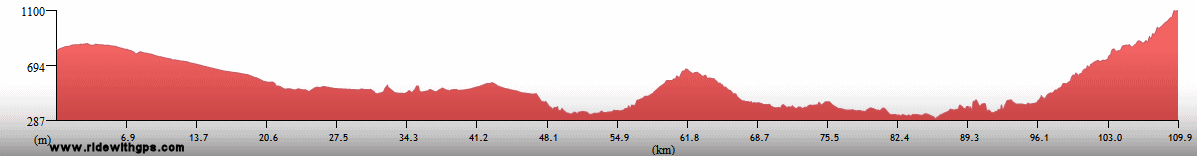
March 23
Butwal to Syangja Bazaar
Distance: 137 km
Terrain: Mountainous; 920-m climb, 700-m descent, 400-m climb
Max. Elevation: 1,422 m
Roads: Siddhartha Hwy
Max. Temp: 34 °C
Weather: Sunny
Accommodation:
Comment: A mixed day, beautiful but tough ride on decent road, but slightly late start and extra 10-km due to inaccurate directiins in Butwal; lost lucky hat (!)
March 24
Pokhara
Distance: 40 km
Accommodation:
Comment: Short ride (inc. 400-m descent) to a rest day at Pokhara; not feeling well again
March 25
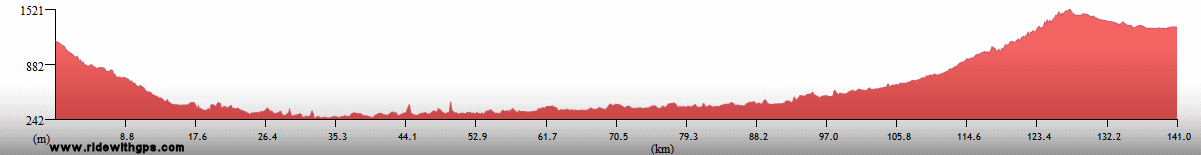
Pokhara to Gorkha
Distance: 115 km
Terrain: Flat to moderate rolling with a couple small hills, 620-m climb
Max. Elevation: 1,380 m
Roads: Prithvi Hwy (H10)
Max. Temp: 32 °C
Weather: Sunny
Accommodation:
Comment: A short, easier day; felt much better; interesting visit to Gorkha
March 26
Gorkha to Kathmandu
Distance: 143 km
Terrain: 620-m descent, then light to heavy rolling, 1170-m climb, first 700-m very gradual
Max. Elevation: 1,618 m
Roads: Prithvi Hwy
Max. Temp: 35 °C
Weather: Sunny; a few strong tailwinds in afternoon
Accommodation:
Comment: A very nice day, but last climb much longer than anticipated and last few kms completely jammed up by trucks
March 27
Kathmandu
Accommodation:
Comment: Rest day in Kathmandu
March 28
Kathmandu to Last Resort
Distance: 104 km
Terrain: Moderate to heavy rolling, with one small climb, then mountainous, 900-m descent, 600-m climb
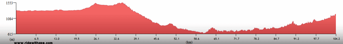
Max. Elevation: 1,550 m
Roads: H3
Max. Temp: 33 °C
Weather: Sunny; a few tailwinds at midday
Accommodation:
Comment: An easy short day ending close to border; light traffic during 2nd half of route, and some nice scenery
March 29
Last Resort to Nyalam
Distance: 58 km
Terrain: 2,570-m climb
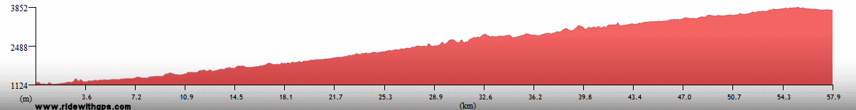
Max. Elevation: 3,848 m
Roads: Friendship Highway
Max. Temp: 23 °C
Weather: Sunny, with clouds increasing in afternoon; occasional moderate winds in afternoon, various directions
Accommodation:
Comment: A continuous climb through the day; road mostly dirt/gravel with occasional rough spots; temperature dropped dramatically during climb
March 30
Nyalam
Accommodation:
Comment: Rest/altitude adjustment day in Nyalam
March 31
Nyalam to Lalung La
Distance: 65 km
Terrain: 1,345-m climb
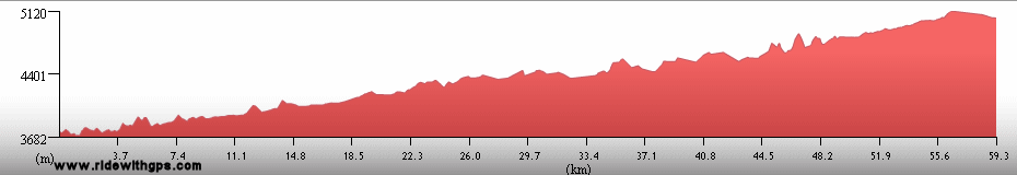
Max. Elevation: 5,105 m
Roads: Hwy 318
Max. Temp: 13 °C
Weather: Sunny; light morning headwinds, some strong afternoon tail/crosswinds
Accommodation:
Comment: A very tiring day over the first big pass (Lalung La); very cold at morning and evening; skipped descent due to corrugated road, frigid temperature, and loss of daylight
April 1
Minbu to Tingri
Distance: 60 km
Terrain: Light to moderate rolling
Max. Elevation: 4,400 m
Roads: Hwy 318
Max. Temp: 17 °C
Weather: Sunny; very strong tail/crosswinds in afternoon and evening
Accommodation:
Comment: A short but tiring half day, especially due to heavily corrugated road
April 2
Tingri to Shegar
Distance: 62 km
Terrain: Light rolling
Max. Elevation: 4,300 m
Roads: Hwy 318
Max. Temp: 16 °C
Weather: Sunny; very strong afternoon tailwinds
Accommodation:
Comment: Another half day; a little less tiring, but still bumpy gravel road
April 3
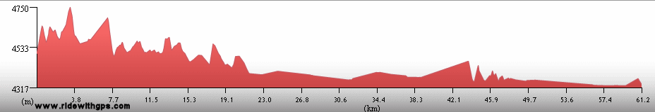
Shegar to 5-km N. of Gyatso La
Distance: 57 km
Terrain: Mountainous; 990-m climb; part of 1,100-m descent
Max. Elevation: 5,220 m
Roads: Hwy 318
Max. Temp: 14 °C
Weather: Mostly sunny, increasing clouds in
afternoon
Accommodation:
Comment: Felt essentially exhausted during climb to highest point of tour (Gyatso La); skipped most of descent due to extremely rocky road
April 4
Lhatse
Accommodation:
Comment: Rest day in Lhatse
April 5
Lhatse to Choitongmoin
Distance: 85 km
Terrain: Flat to moderate rolling
Max. Elevation: 4,050
Roads: Yangdrop
Tsangpo Rd.
Max. Temp: 23 °C
Weather: Sunny, increasing clouds in evening; very strong tailwinds
Accommodation:
Comment: A surprisingly slow, though short, day, mostly due to bumpy road and dust blown up by heavy winds; main highway closed due to construction, alternate route along river was nice, though rough in places, and avoided a minor pass
April 6
Choitongmoin to Shigaste
Distance: 88 km
Terrain: Light rolling to flat
Max. Elevation: 3,960 m
Roads: Yangdrop
Tsangpo Rd.
Max. Temp: 18 °C
Weather: Mostly sunny; light headwinds
Accommodation:
Comment: A generally easy half day on first paved road used in Tibet, but surprising change in wind slowed things down a bit
April 7
Shigaste
Accommodation:
Comment: Rest/sightseeing day in Shigaste; visited Tashi-Lhunpo Monastery
April 8
Shigaste to Gyantse
Distance: 96 km
Terrain: Flat to light rolling
Max. Elevation: 4,030
Roads: Hwy 204
Max. Temp: 19 °C
Weather: Mostly sunny, increasing clouds in afternoon, brief evening snow flurries; occasional mild headwinds
Accommodation:
Comment: Long half day to rest break in Gyantse; best riding conditions in Tibet so far
April 9
Gyantse
Accommodation:
Comment: Rest/sightseeing day in Gyantse; visited Gyantse Dzong and Palkhor Tschode Monastery
April 10
Gyantse to Naggarste
Distance: 104 km
Terrain: Light to moderate rolling, then mountainous; 970-m climb (broken by short descent), 500-m descent
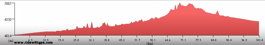
Max. Elevation: 5,010 m
Roads: Gyantse-Chutso Rd.
Max. Temp: 16 °C
Weather: Sunny to partly cloudy, cloudy and cold on big climb; light headwinds in morning, strong tailwinds in afternoon
Accommodation:
Comment: Generally best conditions of the big passes (Karo La), road gravel, but fair condition
April 11
Naggarste to Lhasa
Distance: 159 km
Terrain: Light to moderate rolling, one mountainous section; 500-m climb, 1,100-m descent; then flat to light rolling
Max. Elevation: 4,990 m
Roads: Gyantse-Chutso Rd., Hwy 318
Max. Temp: 25 °C
Weather: Sunny to partly cloudy; very strong tailwinds
Accommodation:
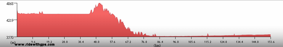
Comment: A beautiful ride, all paved roads; nice section along Yamdok Yumtso, then a great descent from Khamba La; arrived in Lhasa for a long rest break
April 12
Lhasa
Accommodation:
Comment: Rest day in Lhasa
April 13
Lhasa
Accommodation:
Comment: Rest day in Lhasa
April 14
Lhasa
Accommodation:
Comment: Rest/sightseing day in Lhasa; visited Jokhang Temple and Sera Monastery
April 15
Lhasa
Accommodation:
Comment: Rest/sightseing day in Lhasa; visited Potala Palace
April 16
Lhasa to Nyimu Bridge
Distance: 126 km
Terrain: Flat to light rolling, then a short section of moderate rolling
Max. Elevation: 3,770 m
Roads: Hwy 318
Max. Temp: 24 °C
Weather: Sunny, afternoon clouds; headwinds increasing from mild to very strong through the day
Accommodation:
Comment: Began return route to Nepal, took Shigaste short-cut on nice paved road; easy riding at first, tiring as wind picked up
April 17
Nyimu Bridge to Shigaste
Distance: 145 km
Terrain: Light to moderate rolling
Max. Elevation: 3,930 m
Roads: Hwy 318
Max. Temp: 26 °C
Weather: Mostly cloudy, light to strong headwinds, decreasing by evening
Accommodation:
Comment: Good conditions, but a tiring day due to winds
April 18
Minbu
Accommodation:
Comment: Transfer day back to Minbu to avoid bad roads and headwinds
April 19
Nyalam
Accommodation:
Comment: Another slow transfer to Nyalam, due to big snowstorm
April 20
Nyalam
Accommodation:
Comment: Snowbound in Nyalam
April 21
Nyalam to Barhabise, Nepal
Distance: 71 km
Terrain: 2,750-m descent, slightly rolling in places

Max. Elevation: 3,760 m
Roads: Hwy 318; H3 (Nepal)
Max. Temp: 23 °C
Weather: Sunny
Accommodation:
Comment: First 12 km wet/snowy, had to walk past 3 avalanches and through 5 km of deep snow; rest of descent somewhat slow due to wet, rocky road and several slide areas
April 22
Barhabise to Khathmandu
Distance: 93 km
Terrain: Moderate to heavy rolling, with gradual elevation loss and one small climb, 900-m climb and small descent
Max. Elevation: 1,550 m
Roads: H3
Max. Temp: 29 °C
Weather: Sunny, a few mild headwinds at midday; late afternoon thunderstorm
Accommodation:
Comment: Long half day to break in Kathmandu; last 10 km rode with huge anti-monarchy protest march
April 23
Khathmandu
Accommodation:
Comment: Rest day in Kathmandu; government curfew during daytime
April 24
Khathmandu
Accommodation:
Comment: Rest/sightseeing/chores day in Kathmandu; government curfew during daytime; King abdicates in evening
April 25
Khathmandu to Hetuada
Distance: 140 km
Terrain: Mountainous, 540-m descent, 1,740-m climb (broken by short descent), 1,900-m descent
Max. Elevation: 2,500 m
Roads: H2
Max. Temp: 33 °C
Weather: Partly cloudy
Accommodation:
Comment: Pleasant, but tiring day; much more climbing than anticipated; map under-represented distance again
April 26
Hetuada to Sugauli, India
Distance: 111 km
Terrain: 300-m climb, 600-m descent, then flat
Max. Elevation: 780 m
Roads: H2, Hwy 28A (terrible condition)
Max. Temp: 34 °C
Weather: Morning cloudy, with one strong thunderstorm, then mostly sunny
Accommodation:
Comment: A slow, annoying day; did not get as far as hoped due to storm, border formalities, bad road, and a couple mechanical issues
April 27
Sugauli to Muzaffarpur
Distance: 111 km
Terrain: Flat
Max. Elevation: <300 m
Roads: Hwy 28A (very rough condition), Hwy 28
Max. Temp: 37 °C
Weather: Sunny/hazy; very strong cross/headwinds
Accommodation:
Comment: A very tough short day due to bad road and winds
April 28
Muzaffarpur to Patna
Distance: 102 km
Terrain: Flat
Max. Elevation: <300 m
Roads: Hwy 77, Hwy 19
Max. Temp: 39 °C
Weather: Sunny; strong crosswinds
Accommodation:
Comment: Meant to be a half day, but heat and 20 extra km due to bad directions made it feel like full day
April 29
Patna to Gaya
Distance: 117 km
Terrain: Flat
Max. Elevation: 310 m
Roads: Hwy 30, Hwy 83
Max. Temp: 38 °C
Weather: Sunny; mild to light cross/tailwinds
Accommodation:
Comment: Another short day, greatly improved roads, traffic, and wind, but heat still slowed things down
April 30
Bodh Gaya
Distance: 16 km
Accommodation:
Comment: Rest/sightseeing day in Bodh Gaya; visited Mahabodi Temple
May 1
Bodh Gaya to Hazaribad
Distance: 122 km
Terrain: Light rolling, then extremely gradual 410-m elevation gain
Max. Elevation: 780 m
Roads: Manapur Rd. (1/3 nice pavement, rest good dirt with several rough sections), Hwy 2, Hwy 33
Max. Temp: 41 °C
Weather: Sunny; light afternoon cross/tailwinds
Accommodation:
Comment: Another scorcher; morning short-cut was not much of an advantage
May 2
Hazaribad to Khunti
Distance: 133 km
Terrain: Light to moderate rolling, with a couple small climbs/descents
Max. Elevation: 845 m
Roads: Hwy 33, Hwy 38
Max. Temp: 41 °C
Weather: Sunny, with late afternoon clouds; light to moderate cross/tailwinds
Accommodation:
Comment: Still very hot, but otherwise a reasonable day; too much traffic north of Ranchi
May 3
Khunti to 21 km N. of Champua
Distance: 146 km
Terrain: Moderate rolling to hilly
Max. Elevation: 780 m
Roads: Hwy 38, Hwy 39
Max. Temp: 39 °C
Weather: Sunny, evening thunderstorm; light to moderate cross/headwinds in afternoon
Accommodation:
Comment: A much nicer start to the day; beautiful road with little traffic; a little slower in afternoon due to wind; first nice camping spot in weeks, but rain spoiled it
May 4
21 km N. of Champua to Ghatgaon
Distance: 136 km
Terrain: Light to moderate rolling
Max. Elevation: 675 m
Roads: Hwy 39 (terribly rough), Hwy 215 (several long rough sections)
Max. Temp: 39 °C
Weather: Sunny
Accommodation:
Comment: A tedious day; did not get as far as hoped due to bad roads
May 5
Ghatgaon to Cuttack
Distance: 150 km
Terrain: Light to moderate rolling, with some elevation loss
Max. Elevation: 540 m
Roads: Hwy 215, Hwy 5
Max. Temp: 40 °C
Weather: Sunny; moderate to very strong afternoon headwinds
Accommodation:
Comment: Another long, hot day; very slow due to winds
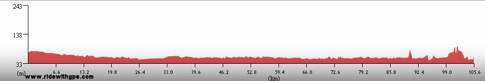
May 6
Chennai
Distance: 28 km
Accommodation:
Comment: Short ride to sightseeing break and afternoon air transfer to Chennai; visited Sun Temple at Konarka
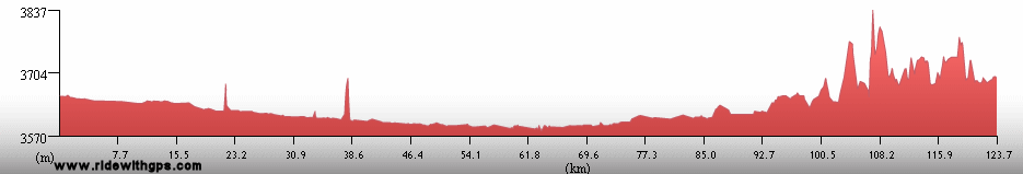
May 7
Colombo Aprt, Sri Lanka to Chilaw
Distance: 62 km
Terrain: Flat to light rolling
Max. Elevation: <300 m
Roads: A3
Max. Temp: 32 °C
Weather: Mostly to partly cloudy
Accommodation:
Comment: Short ride after morning flight to Sri Lanka
May 8
Chilaw to Anuradhapura
Distance: 133 km
Terrain: Flat, then moderate rolling
Max. Elevation: <300 m
Roads: A3, A12
Max. Temp: 32 °C
Weather: Partly cloudy; light tailwinds
Accommodation:
Comment: A fairly easy day, but slow pace due to wear of bike parts
May 9
Anuradhapura
Distance: 23 km
Accommodation:
Comment: Rest/recovery/sightseeing day in Anuradhapura; visited Sacred City sites
May 10
Anuradhapura to Sigiriya
Distance: 94 km
Terrain: Flat to light rolling
Max. Elevation: <300 m
Roads: A12, A13, A9, A5, Sigiriya Rd.
Max. Temp: 35 °C
Weather: Sunny
Accommodation:
Comment: Long half day for sightseeing and rest; visited Golden Temple Cave at Dambulla and Sigiriya Rock Fortress
May 11
Sigiriya to Kalkudah
Distance: 133 km
Terrain: Light to moderate rolling
Max. Elevation: <300 m
Roads: Sigiriya Rd., A11, Kalkudah Rd.
Max. Temp: 34 °C
Weather: Mostly sunny
Accommodation:
Comment: Felt a little better, but still a slightly slow pace; visited Polonnaruwa Ruins
May 12
Kalkudah to Batticaloa
Distance: 46 km
Terrain: Flat
Max. Elevation: <300 m
Roads: B184, A15
Max. Temp: 35 °C
Weather: Sunny
Accommodation:
Comment: Half day after short rest at Kalkudah Beach; first swim in Sea in five months; prevented from taking direct route to Kandy by Tamil Tigers, had to return to Batticaloa instead
May 13
Batticaloa to Maha Oya
Distance: 134 km
Terrain: Flat, then light to moderate rolling
Max. Elevation: <300 m
Roads: A4, A32, A27
Max. Temp: 36 °C
Weather: Partly sunny to partly cloudy
Accommodation:
Comment: Easy conditions, but a fairly tedious day; route went around Tamil Tiger area
May 14
Maha Oya to Kandy
Distance: 132 km
Terrain: Moderate to light rolling; 750-m climb, 400-m descent; then heavy rolling
Max. Elevation: 855 m
Roads: A27, A26
Max. Temp: 36 °C
Weather: Mostly sunny, increasing clouds and one thundershower in afternoon
Accommodation:
Comment: Some nice sections, but terrain, weather and sick bike kept pace slow
May 15
Kandy
Accommodation:
Comment: Rest/sightseeing day in Kandy; visited Dadala Maligawa Tooth Relic Temple
May 16
Kandy to Kegalla
Distance: 45 km
Terrain: Heavy rolling, 300-m descent then moderate rolling
Max. Elevation: 520 m
Roads: A1
Max. Temp: 34 °C
Weather: Mostly sunny
Accommodation:
Comment: Short half day to rest/recovery break in Kegalla; shortened remainder of route to get a little more rest
May 17
Kegalla to Colombo
Distance: 85 km
Terrain: Moderate to heavy rolling, then light rolling to flat
Max. Elevation: <300 m
Roads: A1
Max. Temp: 33 °C
Weather: Partly sunny
Accommodation:
Comment: Half day to extra rest/recovery break in Colombo
May 18
Colombo
Accommodation:
Comment: Rest day in Colombo
May 19
Colombo
Accommodation:
Comment: Rest/sightseeing day in Colombo; rail excursion to visit Galle Fort
May 20
Colombo to Chennai, India
Accommodation:
Comment: Air transfer to Chennai
May 21
Chennai to Kanchipuram
Distance: 141 km
Terrain: Flat
Max. Elevation: <300 m
Roads: Hwy 49, Hwy 58
Max. Temp: 36 °C
Weather: Sunny; moderate to light cross/tailwinds
Accommodation:
Comment: A fairly easy day; extra 8 km due to wrong turn; visited Mamallapuram temple ruins
May 22
Kanchipuram to Chitoor
Distance: 92 km
Terrain: Light rolling, with gradual elevation gain and a few small hills
Max. Elevation: <300 m
Roads: Hwy 4
Max. Temp: 38 °C
Weather: Sunny; strong to very strong headwinds, diminishing somewhat in afternoon
Accommodation:
Comment: A short, very tiring, day due to strong winds
May 23
Chitoor to Madanapelle
Distance: 101 km
Terrain: Light to moderate rolling, with very gradual 450-m elevation gain
Max. Elevation: 600 m
Roads: Hwy 4, Hwy 219
Max. Temp: 35 °C
Weather: Sunny; occasional light to moderate head/crosswinds
Accommodation:
Comment: Another short day, but conditions fairly nice
May 24
Madanapelle to Anantapur
Distance: 179 km
Terrain: Light to moderate rolling, with gradual elevation loss
Max. Elevation: 545 m
Roads: Hwy 219, Hwy 205
Max. Temp: 34 °C
Weather: Cloudy; moderate to strong head/crosswinds, diminishing in afternoon
Accommodation:
Comment: A very long day to make up for previous two; a little easier when turning out of wind; clouds made day feel much more comfortable
May 25
Anantapur to Bellary
Distance: 109 km
Terrain: Light to moderate rolling, with slight elevation gain
Max. Elevation: 360 m
Roads: Hwy 32, Hwy 63 (some bumpy sections)
Max. Temp: 36 °C
Weather: Partly sunny, then mostly couldy
Accommodation:
Comment: An extremely slow, tiring, short day due to bad winds
May 26
Bellary to Hospet
Distance: 63 km
Terrain: Light rolling
Max. Elevation: 425 m
Roads: Hwy 63 (long rough sections)
Max. Temp: 35 °C
Weather: Mostly cloudy, to partly cloudy; light headwinds
Accommodation:
Comment: A fairly short half day to rest break at Hospet, a little slow due to poor road; visited Vijayanagar city ruins at Hampi
May 27
Hospet to Pattadal Kallu
Distance: 151 km
Terrain: Light to moderate rolling
Max. Elevation: 520 m
Roads: Hwy 13, Hwy 20, Hwy 14
Max. Temp: 35 °C
Weather: Partly to mostly cloudy; light to moderate crosswinds
Accommodation:
Comment: A reasonable day, some sections with heavy traffic, but a little easier after turning out of the wind
May 28
Pattadal Kallu to Hubli
Distance: 138 km
Terrain: Light rolling
Max. Elevation: 560 m
Roads: Hwy 14, Hwy 30, Hwy 218
Max. Temp: 35 °C
Weather: Partly to mostly cloudy, light crosswinds; one moderate shower with very strong wind
Accommodation:
Comment: A fairly tiresome day due to a few rough sections of road with rain; visited Pattada Kallu Temple ruins
May 29
Hubli to Dharwad
Distance: 54 km
Terrain: Moderate rolling
Max. Elevation: 620 m
Roads: Hwy 4, Hwy 34
Max. Temp: 34 °C
Weather: Mostly cloudy
Accommodation:
Comment: Bike has worn down to virtual non-usability, monsoons have arrived! will end stage in Goa.
May 30
Dharwad to Panaji, Goa
Accommodation:
Comment: Final day of Stage 2!!, mostly a rail transfer;
Index | Next Page
Pre-Tour Stage 1 Stage 2 Stage 3 Stage 4 Stage 5 |