Stage 3: From Green to Brown
Another wet start in an unexpected place, then into the sky
and onto the plains
The Tour Reports section of the site now contains the posts that I sent to the Phred Touring List (now on Google Groups) during the Tour. Those from the early days of the Tour were rather thin, while later on, for some of the more unique countries, they contain much more thorough accounts of the ride, and an occasional amusing anecdote. Towards the end of the Tour, however, I frequently couldn't keep up with the chore of sending posts on time, so the last several were written after the Tour was complete. Look for links to the posts at the end of the short descriptions beginning below.
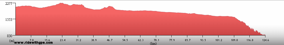
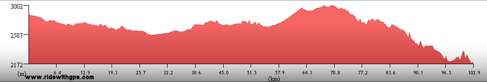
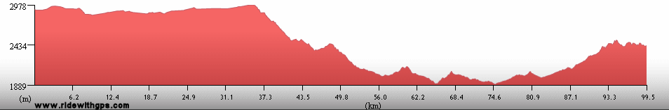
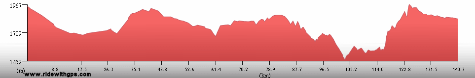
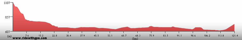
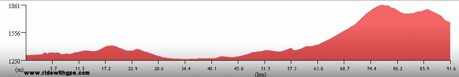
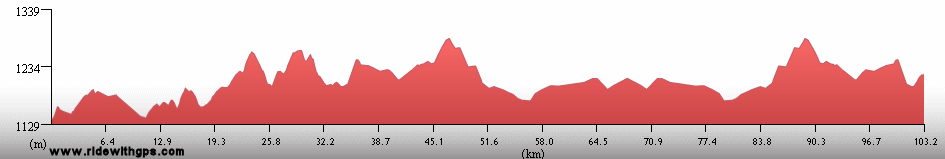
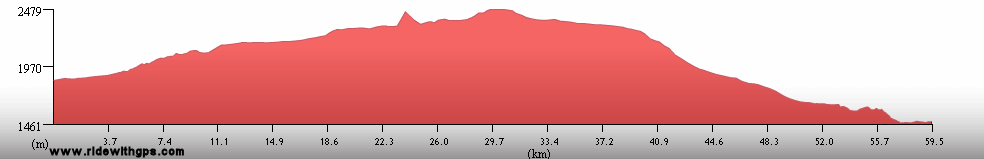
Stage 3 Actual Route

On this, and all other route maps, the blue lines represent travel by ship, red by airplane (Booo!), and green by bicycle. The actual route for Stage 3 was considerably modified at the beginning and at the end from my original plans, while the middle section went according to the original route. A long tour through Ethiopia was added, and consequently the route through northern Kenya had to be changed. Big changes were made (twice) to the in route South Africa thanks to my sea transfer plans, which, annoyingly, were cancelled. Twice. Swaziland was removed from the route, then returned later on, and Madagascar was shortened, which was a huge disappointment. On the other hand, I did manage to ride all the way to Cape Town, which was one of my original goals, and one that I did not think I would have time to achieve.
Ethiopia: A New Start in a Fascinating Place
With the various possible changes to my sea transfer from Asia to Africa, I needed to come up with a new staring point for Stage 3. There were not many to choose from, as you might expect, though I considered still starting at Mombassa, my original choice. Another possibility was Djibouti, and I was fairly intrigued by that city. However, as I looked at a map of the region, I became more and more interested in starting in Ethiopia. I had not considered that country in my original plan, but I soon learned that there are many incredible sights to see in that land. Once I finally settled on a transfer plan from India, which would, unfortunately, require me to arrive in Cairo via air, I decided to officially added Ethiopia to the route. However, that meant another unfortunate bit of flying since I was not very enthusiastic, nor had enough time, to ride through Sudan to Ethiopia. So, my new starting point for the Stage, would be Axum, Ethiopia, a small town in the very north of the country, close to the closed border with Eritrea, and a town right in the heart of the countries historic zone. As has now become a tradition for the Tour, that meant that the start of the Stage would be rough and wet. July is near the beginning of the rainy season, and the northern areas of the country are well-known for rugged terrain and bad roads. Why break with tradition?
The route then began in Axum, the capital of the ancient Axumite Kingdom, then ran to the west and south, through the rugged Simyen mountains. The entire area consisted of very slow and difficult traveling, but with the frequent rains, the landscape was fresh with brilliant green colors. Continuing on, I visited Gondar, which contains some interesting historic site, and Bahir Dar, a relatively large town on the shore of Tana Hayk, the lake that is the source of the Blue Nile, and which contains several interesting monasteries on its small islands. Some more difficult riding led to the one of the more impressive sights of the Stage, the 11 Rock-Hewn Churches in Lalibela. Going there was not easy, but it was well worth the extra effort. Beyond there, the roads were usually much better though there was still some rough terrain and bad weather. In spite of that, I reached the capital, Addis Ababa, after a while for a short rest break. The route then continued to the south, through a part of the country that contained a variety of landscapes, but was generally a little drier than the area I had just left in the north. That region was also where I had my first encounter with Africa’s Great Rift Valley. There, a huge piece of Gondwanaland is splitting off from the main body of Arfica, and slowly heading out into the Indian Ocean. I would meet the rift many more times before the Stage was complete In that area, traveling conditions were a lot easier, but I was already 5 or 6 days behind where I wanted to be by that time. Nevertheless, I reached the Kenyan border at Moyeni, without much additional trouble.
An interesting start to the Stage in this post: ~HERE~

The Simyen Mountains

Four women from northern Ethiopia

A painting showing the Ark of the Covenant in an Axum church

Men along the road to Weldiya

Interior of a Rock-Hewn Church in Lalibela

A Golden-Breasted Starling

A traditional procession in southern Ethiopia
Kenya: Rocks and Clouds
Arriving at Moyeni at the Ethiopian border was a significant change from my original plans to start at the pleasant Kenyan seacoast. In fact, the entire route through Kenya was considerably adjusted and was not really as long or as interesting as I would have liked. The entire route in the northern part of the country was extremely, and surprisingly, tough as the highway deteriorated to a rocky nightmare while crossing the lonely Dida Galgalu desert. After a while, I reached the central part of the country, surrounding Mount Kenya, which was much more developed than the areas I had previously crossed. The weather there was always cloudy, however, and I never really saw the great mountain. However, in this region, I did have my first encounters with African megafauna, one of the few parts of the continent were I did so outside of a game park. The route continued south, through Nairobi. Normally I would never visit such a large city on tour, but sometimes there is no easy way to bypass the major cities. In this case, I was happy to get to a place where I could have a few decent meals. The end of the route through Kenya was a quick ride to the Tanzanian border post at Namanga.
A brief post for Kenya is found: ~HERE~

The Dida Galgalu Desert in northern Kenya

Camels at a rural trading center

A group of giraffe cross my path

A man in a small village

Crossing the Equator near Meru
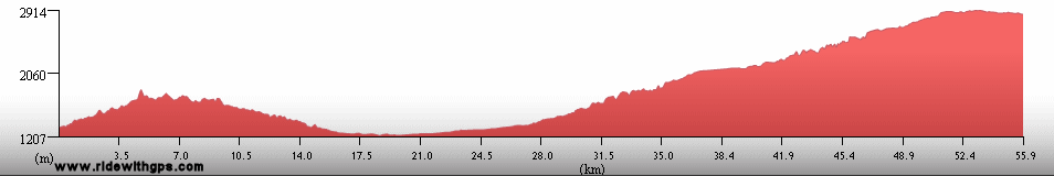
Mount Kilimanjaro: Off the Bike and Towards the Sky
Mount Kilimanjaro was, obviously, a section of the Tour where I spent a week off the bike. I was very interested to see the fast-shrinking glaciers on the summit of the 6,000 meter peak, as well as the unique, endemic, plant life which grows in the Afro-Alpine zones. Of course, there is no way to do that other than to take a 5-6 day trek up to the peak with a licensed tour company. That was rather costly, and I did feel considerably guilty to have the large crew of porters carry most of my belongings, as well as those of the many other climbers. Nevertheless, I was completely fascinated by the environment of the mountain, and proud of myself for reaching the summit, though at an eerily dark hour of 4:50 AM. It was a rather difficult climb, especially since I was much more used to cycling than walking, and because the day before I started, I sprained my left wrist during an encounter with some over-enthusiastic young boys, one of Africa's most dangerous creatures.

Uhuru peak of Kilimanjaro

Lobelia Deckenii, a plant endemic to the Afro-Alipne zones

Me and a Giant Senecio, another Afro-Alpine endemic

I reach the summit of Kilimanjaro at 4:50 A.M.
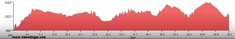
Tanzania: More Time Off the Bike
Tanzania was probably the place where I spent the most time off of the bike during the entire Tour. That was not necessarily a bad thing, as it gave my sore wrist a chance to heal somewhat, and since the breaks involved seeing some impressive sights. The route started in the vicinity of Kilimanjaro, at the Kenyan border, where it involved riding to Moshi the starting point for the climb, and then to, and beyond Arusha, the base for visiting the famous game parks of northern Tanzania. Those, for rather obvious reasons, don’t allow individual travel, or cycling, in the parks. To see the parks, and their famous wildlife, one must book a standard safari. Mine was rather costly, since I was traveling solo, but made a little more affordable since I chose to bypass the luxurious lodges and camp in the designated campsites. I visited three parks, Lake Manyara, Ngorongoro Crater, and Serengeti, in the company of a guide, driver, and cook. The animal viewing was actually a bit better than I thought it might have been, and I made good sightings of almost all of the major species. Nevertheless, by the time we reached the western exits of the parks, I was more than ready to begin cycling again.
After leaving the parks, I rode to the shore of Lake Victoria, and spent a relaxing day at the relaxed town of Mwanza. My next goal was the border of Rwanada, and there were some unpleasantly rough gravel roads between Mwanza and there, made all the more uncomfortable by my bad wrist. Eventually, I reached the border and left the country for a couple of weeks. My last visit to Tanzania included more time off the bike. Arriving by bike at Kigoma, a port town on Lake Tanganyika, I arranged passage on the MV Liemba. That ship is an old lake ferry built in the early 20th century, which now takes passengers and some cargo up and down the length of the long, narrow lake. To me it seemed a nice way to skip the bad roads of western Tanzania, and have a brief rest in the process. The 2-3 day voyage was interesting, if not exactly quiet, and there was some beautiful scenery along the way. In all the Liemba was an effective and way for my to cross some rather difficult territory. I left the ship at its southernmost port, Mplungu, Zambia.
Kilimanjaro and Tanzania, both in this post: ~HERE~

Wildlife at Lake Manyara National Park

Wildlife in Ngorongoro Crater

Men of a Maasai Village

Elephants in Serengeti National Park

On the M.V. Liemba, the Lake Tanganyika Ferry

Sunset over Lake Tanganyika
Rwanda & Burundi: Small Lands Struggling to Recover
Rwanda and Burundi were also late additions to my route. I decided after visiting Cambodia, another country which suffered greatly in recent decades, that I also wanted to see these two small lands to see how they have recovered from the horrible events of the 01990's. Rwanda came first, and I entered the country at the small border post at Rusumo Falls. I was quite surprised by many aspects of Rwanada, especially that the country is one of the most heavily populated in Africa. That was readily apparent after seeing the farms and gardens, which line the sides of hills and mountains running straight up to their summits. I was also a little surprised that the country had some of the best food that I found in Africa. Additionally, the rather modern infrastructure, especially the good roads, was a pleasant change of pace. This was all more apparent as I reached the rather modern capital of Kigali. After staying there for a day, I rode up to the northern area, the landscape of which is dominated by several large volcanoes, The conditions in that part of the country were rather good, though the towns had a more African feel than Kigali did. A little bit of confusion at the end of the route cause me to change my plans slightly, and take another voyage over water, specifically an overnight transfer down Lac Kivu on a beer-transport boat, to the town of Cyangugu, near the Burundi border.
Burundi was a somewhat different experience. The conflict in that country lingered on much longer than it had in Rwanada, only effectively ending a just couple of years before my visit. Consequently, the infrastructure in Burundi was much rougher than it was in Rwanda. That was especially evident in terms of food, where it proved to be rather tough to find a decent meal. Because of those factors, I really didn't plan to stay very long, or ride to many destinations. The route was simply a ride south from the Rwanada border, south to the capital, Bujumbura, a rather hectic town, and then straight down the coast of Lake Tanganyika to the Tanzanian border. Apart from a few light food days, I did have a fairly easy time of it, and made it to Tanzania just in time to catch the Liemba. As the two countries are both quite small, my visits were rather short, but I enjoyed both the places and the people of the two lands and I was glad I added them to the route. Hopefully, the conflicts of the past are gone for good, and both will continue to recover and rebuild their societies
Two small countries, described in this post: ~HERE~

A Genocide Memorial Sign near Kigali

A Refugee Tent City near the Tanzanian border

Women carrying baskets

Volcan Gahinga and Volcan Muhabura, home of Mountain Gorillas

Boats near the Burundian shore of Lake Tanganyika

A lakshore market in Burundi
Previous | Next
Main Index | Pre-Tour Index
Post-Tour Index | Articles Index
Slideshows
Stage 3 Log
For a description of terms and symbols look: ~HERE~
July 6, 02006
Axum, Ethiopia
Distance: 7 km
Max. Elevation: 2,130 m
Max. Temp: 19 °C
Weather: Afternoon rain
Accommodation:

Comment: Sightseeing day in Axum; visited historic churches and stelae
July 7
Axum to Tekeze Wenz R.
Distance: 126 km
Terrain: Moderate rolling to flat, then light rolling with gradual loss of elevation, 780-m descent
Max. Elevation: 2,220 m
Roads: Rte. 3 (good quality dirt/gravel)
Max. Temp: 30 °C
Weather: Cloudy, becoming mostly cloudy by evening
Accommodation:

Comment: Except for two defective tires, a much better day than anticipated; legs not too bad after long layoff, road mostly better than feared, and no rain; saw many beautiful birds
July 8
Tekeze Wenz River to 20 km S. of Adi Arkay
Distance: 75 km
Terrain: 580-m climb, light rolling, two 300-m climbs/descents, 300-m climb, 400-m descent
Max. Elevation: 1,720 m
Roads: Rte. 3 (very rocky, especially on hills)
Max. Temp: 32 °C
Weather: Cloudy, a little morning drizzle, brief period of light rain in evening
Accommodation:
Comment: A very tough day, due to rocky roads and rough terrain; lost brand new "lucky" hat; some exceptional scenery
July 9
20 km S. of Adi Arkay to Debark
Distance: 60 km
Terrain: Mountainous; 400-m climb/descent, 1,530-m climb
Max. Elevation: 2,888 m
Roads: Rte 3. (Rocky)
Max. Temp: 23 °C
Weather: Partly sunny through morning, becoming cloudy; two thunderstorms during last big climb
Accommodation:

Comment: One of the slowest days ever, due to rocky road, rain and larger climb than expected (Wolkeld Pass); little food available on route; more exceptional scenery
July 10
Debark to Gondar
Distance: 104 km
Terrain: Light rolling with gradual descent, 350-m climb, 730-m descent
Max. Elevation: 2,980 m
Roads: Rte. 3 (hard dirt or packed gravel, mostly good quality except for some rough or wet sections)
Max. Temp: 16 °C
Weather: Mostly cloudy; a couple periods of drizzle, heavy shower at sunset; light crosswinds
Accommodation:
Comment: An easier day, especially in morning; damp roads slowed pace in afternoon
July 11
Gondar
Weather: Cloudy, with a few heavy showers
Accommodation:
Comment: Rest/sightseeing day in Gondar; visited Emperor Fasilidas's Castles and Debre Berhane Selassie Church
July 12
Gondar to Bahir Dar
Distance: 177 km
Terrain: Light rolling, with one small hill; 350-m climb/descent; short flat section; moderate to heavy rolling
Max. Elevation: 2,350 m
Roads: Rte. 3 (smooth pavement)
Max. Temp: 30 °C
Weather: Partly sunny to cloudy; evening showers; occasional moderate crosswinds in afternoon
Accommodation:
Comment: A long but mostly easy day to rest break at Bahir Dar; first good road on route; effects of some bad food and evening showers made last 1/3 of route less pleasant
July 13
Bahir Dar
Weather: Mostly Cloudy
Accommodation:
Comment: Rest/sightseeing day in Bahir Dar; visited Tana Hayk island monasteries
July 14
Bahir Dar to Debre Tabor
Distance: 112 km
Terrain: Moderate rolling, then light rolling with gradual elevation gain; 540-m climb
Max. Elevation: 2,740 m
Roads: Rte. 3, Werota-Weldiya Rd. (rough dirt/rocks)
Max. Temp: 32 °C
Weather: Mostly to partly sunny; evening thundershowers; moderate to strong head/crosswinds through early morning
Accommodation:
Comment: Easy start, rough finish; would have preferred to go a little farther, but poor road slowed progress
July 15
Debre Tabor to 30 km W. of Gashena
Distance: 110 km
Terrain: Hilly to mountainous; gradual 580-m climb, 300-m descent
Max. Elevation: 3,240 m
Roads: Werota-Weldiya Rd. (moderate dirt/gravel with some rough spots)
Max. Temp: 22 °C
Weather: Partly sunny with a few brief showers
Accommodation:
Comment: A reasonable day considering road condition and terrain; would have gone a little farther but delayed by retrieval of tool kit from teen punk thief
July 16
30 km W. of Gashena to Lalibela
Distance: 97 km
Terrain: Light to moderate rolling; 800-m descent; hilly; steep 460-m climb
Max. Elevation: 2,940 m
Roads: Werota-Weldiya Rd. (gravel/dirt, with several long rough sections), Gashena-Lalibela Rd. (moderate to good quality gravel, last 15 km paved)
Max. Temp: 27 °C
Weather: Partly cloudy
Accommodation:
Comment: A little longer and tougher than expected
July 17
Lalibela
Accommodation:
Comment: Rest/sightseeing day in Lalibela; visited amazing rock-hewn churches
July 18
Weldiya to Wugusa
Distance: 58 km
Terrain: Moderate rolling; hilly; 450-m climb
Max. Elevation: 2,150 m
Roads: Rte. 1 (fair
pavement)
Max. Temp: 25 °C
Weather: Mostly cloudy, one moderate shower in afternoon
Accommodation:
Comment: Skipped dupicate ride down from Lalibela and last section of gravel road, bus transfer to Weldiya; over a 3,500 m pass along the way; short half day ride in afternoon
July 19
Wugusa to 26 km N. of Kara K'ore
Distance: 153 km
Terrain: Mountainous, 350-m descent, 950-m climb, 600-m descent; light rolling to flat with additional elevation loss
Max. Elevation: 2,660 m
Roads: Rte. 1 (55 km of terrible dirt/gravel with many rough or muddy sections; 30 km bumpy pavement; rest new, smooth pavement)
Max. Temp: 32 °C
Weather: Mostly sunny, no rain
Accommodation:
Comment: A complete contrast, lousy morning due to unexpected bad road (map showed pavement); great afternoon made up some time lost in morning
July 20
26 km N. of Kara K'ore to Debre Sina
Distance: 125 km
Terrain: Alternating sections of hilly and light rolling, 300-m climb/descent, 1,260-m climb (incomplete)
Max. Elevation: 2,684 m
Roads: Rte. 1 (excellent pavement until last 10 km of climb which were under repair)
Max. Temp: 34 °C
Weather: Party sunny, hot at start of big climb, huge evening cloudburst with hail
Accommodation:
Comment: A fairly good day, but big storm during evening food break prevented going farther; will try to reach Addis next day but probably won't make it
July 21
Debre Sina to 30 km N.E. of Addis Ababa
Distance: 160 km
Terrain: 680-m climb (completion of previous evening's climb; T'Aramber Pass)
Max. Elevation: 3,370 m
Roads: Rte. 1 (1st 11 km dirt with muddy sections, then bumpy pavement, improving somewhat by the end of the day)
Max. Temp: 18 °C
Weather: Party cloudy in morning, frequent showers midday through evening
Accommodation:
Comment: A reasonable day given conditions; could possibly have reached Addis, but stopped for a decent campsite; saw a big troupe of baboons
July 22
Addis Ababa
Distance: 37 km
Accommodation:
Comment: Short ride to rest break in Addis Adaba
July 23
Addis Ababa
Accommodation:
Comment: Rest/repairs day in Addis Ababa
July 24
Addis Ababa to Ziway
Distance: 161 km
Terrain: Flat to light rolling, with very gradual elevation loss over 1st half of route
Max. Elevation: 2,540 m
Roads: Rte.4, Rte. 6 (both good pavement)
Max. Temp: 27 °C
Weather: Morning and evening clouds, otherwise mostly sunny; strong headwinds midday through sunset
Accommodation:
Comment: Would have been a very easy day except for wind; wanted to camp, but couldn't find a good spot
July 25
Ziway to Sashemene
Distance: 93 km
Terrain: Flat, light to moderate rolling
Max. Elevation: 2,220
Roads: Rte. 6
Max. Temp: 25 °C
Weather: Cloudy, one light shower in afternoon, then partial clearing
Accommodation:
Comment: A long, very slow half day; less wind but feeling poor due to some bad food the previous day, stopped early to recover a little
July 26
Sashemene to Yirga Chefe
Distance: 150 km
Terrain: Light rolling, heavy rolling to hilly, rolling 400-m descent/climb
Max. Elevation: 2,200 m
Roads: Rte. 6
Max. Temp: 28 °C
Weather: Cloudy with occasional drizzle through midday, then partly cloudy
Accommodation:
Comment: Felt much better, an easy start, then terrain slowed things down a little; would have gone a little farther but did not think a campsite would be found due to heavy population
July 27
Yirga Chefe to 60 km S. of Agere Maryam
Distance: 132 km
Terrain: rolling 500-m climb, heavy rolling to hilly; 400-m descent; moderate rolling
Max. Elevation: 2,760 m
Roads: Rte. 6 (fairly long bumpy section)
Max. Temp: 22 °C
Weather: Cloudy and cool until late afternoon, then partial clearing
Accommodation:
Comment: Terrain harder than told or expected; crowds mentally draining; finally broke through into arid region with abundant camping possibilities
July 28
60 km S. of Agere Maryam to 14 km N. of Mega
Distance: 128 km
Terrain: Moderate to heavy rolling
Max. Elevation: 2,030 m
Roads: Rte. 6 (fair to good pavement, a few rougher spots)
Max. Temp: 20 °C
Weather: Cloudy and cool, partial clearing in evening; moderate to strong
headwinds
Accommodation:
Comment: Winds slowed progress a lot; still waiting for elevation loss
July 29
14 km N. of Mega to Moyale, Kenya
Distance: 125 km
Terrain: 300-m climb/descent, light to heavy rolling
Max. Elevation: 2,190 m
Roads: Rte. 6 (fair, with a few long bumpy sections)
Max. Temp: 26 °C
Weather: Mostly cloudy and cold through morning, partial clearing in afternoon; vert strong headwinds through morning, becoming occasional strong cross/headwinds in afternoon
Accommodation:
Comment: Another bad wind day, which negated effect of elevation loss; short day to cross into Kenya; border town dumpy on Kenya side
July 30
Moyale to Turbi
Distance: 120 km
Terrain: 300-m descent; flat to light rolling
Max. Elevation: 1,420 m
Roads: A2 (fair to moderate dirt/gravel; last 20 km very poor)
Max. Temp: 30 °C
Weather: Mostly cloudy
Accommodation:
Comment: Reasonable day considering road condition
July 31
Turbi to Marsabit
Distance: 46 km
Terrain: Flat to light rolling
Max. Elevation: 1,030 m
Roads: A2 (terribly rocky and corrugated)
Max. Temp: 34 °C
Weather: Sunny; strong to moderate crosswinds
Accommodation:
Comment: Had to abandon day's ride almost halfway through due to deteriorating road across Dida Galgalu Desert, almost unrideable; transferred to Marsabit via truck
August 1
Marsabit to Laisamis
Distance: 101 km
Terrain: Moderate rolling to flat
Max. Elevation: 1,150 m
Roads: A2 (Poor to moderate gravel, some long corrugated and soft sections)
Max. Temp: 34 °C
Weather: Sunny; strong to moderate crosswind
Accommodation:
Comment: Fairly easy start, then bogged down in afternoon on corrugated road
August 2
Laisamis to 20 km S. of Sere Dlip
Distance: 90 km
Terrain: Light rolling, then gradual elevation gain
Max. Elevation: 747 m
Roads: A2 (poor dirt/gravel, almost entirely corrugated with lots of sand)
Max. Temp: 35 °C
Weather: Sunny; occasional moderate cross/tailwinds
Accommodation:
Comment: Another tiresome day; expected to get a little farther, but road still a nightmare; actual route distance may be slightly less than map indicated
August 3
20 km S. of Sere Dlip to Meru
Distance: 105 km
Terrain: Moderate rolling, gradual 1000-m climb, steeper near top, heavy rolling, 300-m descent
Max. Elevation: 1,840 m
Roads: A2 (first 75 km poor dirt/gravel, then paved), B6
Max. Temp: 35 °C
Weather: Sunny, partly cloudy late afternoon
Accommodation:
Comment: A really tiring day; map showed only 45 km of gravel, but was actually 75; continued on, but skipped over last 25 km on back of a truck carrying dirt; last climb much higher than expected; saw giraffes, elephants, and colubus monkeys
August 4
Meru
Accommodation:
Comment: Rest day in Meru; clouds blocked view of Mt.Kenya
August 5
Meru to Embu
Distance: 100 km
Terrain: Heavy rolling to hilly, rolling 500-m descent, rolling 300-m climb
Max. Elevation: 1,700 m
Roads: B6
Max. Temp: 25 °C
Weather: Cloudy
Accommodation:
Comment: A fairly easy day; actual route only 65% as long as map indicated (!), could have gone farther, but decided to stay in Embu instead; clouds obscured Mt. Kenya again
August 6
Embu to Nairobi
Distance: 132 km
Terrain: Light to heavy rolling, rolling 300-m descent/climb
Max. Elevation: 1,610 m
Roads: B6, A2 (last 45-km busy high-sped highway, with frequent potholes)
Max. Temp: 22 °C
Weather: Cloudy
Accommodation:
Comment: A fairly fast ride to rest break in Nairobi; too much traffic, especially over final 30 km
August 7
Nairobi
Accommodation:
Comment: Rest/chores day in Nairobi
August 8
Nairobi to Namanga
Distance: 166 km
Terrain: Light to moderate rolling with gradual elevation loss
Max. Elevation: 1,690 m
Roads: A104
Max. Temp: 18 °C
Weather: Cloudy, a little light drizzle
Accommodation:

Comment: A fairly easy day; actual distance slightly shorter than map indicated; would like to see the Sun again
August 9
Namanga to Moshi, Tanzania
Distance: 112 km
Terrain: Moderate rolling, 350-m climb
Max. Elevation: 1,700 m
Roads: Namanga-Arusha Rd., Momella Rd. (fiar to poor dirt/gravel)
Max. Temp: 25 °C
Weather: Cloudy, with some mist through morning, becoming mostly cloudy
Accommodation:
Comment: A rough day; jammed left wrist when knocked down by pesky boys, very hard to ride; 'short' road to Moshi not well-marked; ended up at Arusha N.P. but was not allowed to ride through, had to get a ride with tourists
August 10
Moshi to Machame Camp
Max. Elevation: 3000 m
Accommodation:
Comment: First day of Kili climb; didn't feel very good due to injured wrist
August 11
Machame Camp to Shira Camp
Max. Elevation: 3800 m
Accommodation:
Comment: A nicer day, some sunshine and interesting flora; wrist still badly swollen, but feels a little better
August 12
Shira Camp to Barracu Camp
Max. Elevation: 3900 m
Accommodation:
Comment: Sick from some more bad food, felt extremely sluggish
August 13
Barracu Camp to Barafu Camp
Max. Elevation: 4600 m
Accommodation:
Comment: A bit better, but a very long day
August 14
Barafu Camp to Mweka Camp
Max. Elevation: 5890 m
Accommodation:
Comment: Kili Summit at Uhuru Peak before dawn, success!!
August 15
Mweka Camp to Moshi
Max. Elevation: 3100 m
Accommodation:
Comment: Remainder of descent from Kili, then transfer back to Moshi
August 16
Moshi to Arusha
Distance: 89 km
Terrain: Light rolling, with gradual 700-m elevation gain
Max. Elevation: 1,530 m
Roads: Moshi-Arusha Hwy
Max. Temp: 32 °C
Weather: Partly sunny; occasional mild tailwinds
Accommodation:
Comment: Back on the bike; wrist still painful, but able to ride; an otherwise easy half day; chores and safari preparations in Arusha
August 17
Arusha to Makayuni
Distance: 79 km
Terrain: Flat to light rolling
Max. Elevation: 1,560 m
Roads: A104
Max. Temp: 24 °C
Weather: Cloudy through midday, then sunny; light tailwinds
Accommodation:
Comment: Easy half day to starting point for safari; wrist a little more painful; visited Lake Manyara N.P.; amazing numbers and variety of animals
August 18
Makayuni to Ngorongoro
Accommodation:
Comment: Safari continued; excellent game-viewing day in Ngorongoro Crater
August 19
Ngorongoro to Serengeti Seronera
Accommodation:
Comment: Safari continued; some nice sightings in Serengeti National Park
August 20
Serengeti Seronera to Ramadi
Accommodation:
Comment: End of Safari; exited Serengeti Park at midday
August 21
Ramadi to Mwanza
Distance: 138 km
Terrain: Flat; light to moderate rolling
Max. Elevation: 1,360 m
Roads: B6
Max. Temp: 36 °C
Weather: Sunny; light tailwinds
Accommodation:
Comment: Back on the bike for a day; easiest riding conditions of stage so far, but wrist still painful
August 22
Mwanza
Accommodation:
Comment: Rest day in Mwanza
August 23
Mwanza
Accommodation:
Comment: Extra rest day in Mwanza
August 24
Mwanza to Sengerema
Distance: 99 km
Terrain: Light to moderate rolling
Max. Elevation: 1,423 m
Roads: Kamanga Ferry; Kamanga-Sengerama Rd. (poor to moderate dirt); B153 (fair to good dirt)
Max. Temp: 36 °C
Weather: Sunny; light crosswinds
Accommodation:
Comment: An unproductive day; road tolerable, but bumps aggravated sore wrist; 60 km wasted due to wrong turn
August 25
Lusahunga to Rusumo Falls, Rwanda
Distance: 94 km
Terrain: Heavy rolling to hilly, with one section of light rolling
Max. Elevation: 1,947 m
Roads: B3 (smooth pavement)
Max. Temp: 36 °C
Weather: Sunny; light tailwinds
Accommodation:
Comment: Long half day after bus transfer past last section of dirt road; wrist feels slightly better
August 26
Rusumo Falls to Kigali
Distance: 174 km
Terrain: Hilly; two rolling 300-m climbs, 300-m descent; light rolling
Max. Elevation: 1,973 m
Roads: Rusumo-Kigali Hwy.
Max. Temp: 25 °C
Weather: Hazy sunshine through morning, then mostly cloudy with a heavy thunderstorm during midday meal break; occasional moderate tailwinds
Accommodation:
Comment: A long and fairly tiring day, with some fairly tough terrain; little food/water available over first third of route
August 27
Kigali
Accommodation:
Comment: Rest day in Kigali, emptied wallet for food
August 28
Kigali to Ruhengeri
Distance: 99 km
Terrain: 750-m climb, 500-m descent, moderate rolling, 470-m climb, 400-m descent, one small climb
Max. Elevation: 2,440 m
Roads: Kigali-Ruhengeri Hwy.
Max. Temp: 26 °C
Weather: Mostly sunny, cloudy by evening; occasional moderate tailwinds
Accommodation:
Comment: Long half day to a rest break in Ruhengeri; rode a fairly relaxing pace; wrist felt a bit better; attacked by a swarm of bees
August 29
Ruhengeri
Accommodation:
Comment: Rest day in Ruhengeri
August 30
Ruhengeri to Gisenyi
Distance: 96 km
Terrain: 300-m climb, 850-m descent
Max. Elevation: 2,460 m
Roads: Ruhengeri-Gisenyi Hwy. (many potholes on descent)
Max. Temp: 28 °C
Weather: Partly to mostly cloudy; occasional moderate tailwinds
Accommodation:
Comment: Incorrect map resulted in route change to Gisenyi and Lac Kivu; distance includes 30 km
extra
August 31
Gisenyi
Distance: 14 km
Accommodation:
Comment: Unplanned day off due to incorrect information about Lake transport schedule
September 1
Gisenyi
Distance: 19 km
Accommodation:
Comment: Overnight boat transfer on Lac Kivu to Cyangugu
September 2
Cyangugu to Bujumbura, Burundi
Distance: 132 km
Terrain: 350-m climb; moderate to heavy rolling; 700-m descent; light to moderate rolling; flat
Max. Elevation: 1,960 m
Roads: Cyangugu-Bugarama Rd., Burundi Border Rd, R.N. 5
Max. Temp: 35 °C
Weather: Mostly sunny; moderate to strong
headwinds
Accommodation:
Comment: Very late start due to slow lake boat; much harder day than expected due to terrain and wind; easy border crossing
September 3
Bujumbura
Accommodation:
Comment: Rest Day in Bujumbura
September 4
Bujumbura to Nyanza Lac
Distance: 128 km
Terrain: Light rolling
Max. Elevation: 992 m
Roads: R.N. 3 (first 30 km with many potholes)
Max. Temp: 34 °C
Weather: Sunny; occasional moderate crosswinds
Accommodation:
Comment: A fairly easy day, but felt a little sluggish; little food available on route
September 5
Nyanza Lac to Kigoma, Tanzania
Distance: 115 km
Terrain: 750-m climb, heavy to moderate rolling, rolling 700-m descent (rough)
Max. Elevation: 1,810 m
Roads: R.N. 3, Mabanda-Kigoma Rd. (fair to good dirt until border then very poor quality, rough and sandy
Max. Temp: 32 °C
Weather: Sunny; very strong headwinds in morning, becoming occasional crosswinds in afternoon
Accommodation:
Comment: A very tough day due to winds during big climb, and bad road south of the border
September 6
Kigoma to M.V. Liemba
Accommodation:
Comment: Boarding for M.V. Liemba cruise down Lake Tanganyika
September 7
M.V. Liemba
Accommodation:
Comment: South down Lake Tanganyika on the
M.V. Liemba
September 8
M.V. Liemba to Mplungu, Zambia
Accommodation:
Comment: Afternoon arrival in Mplungu
Continued on Next Page
Index | Next Page
Pre-Tour Stage 1 Stage 2 Stage 3 Stage 4 Stage 5 |