
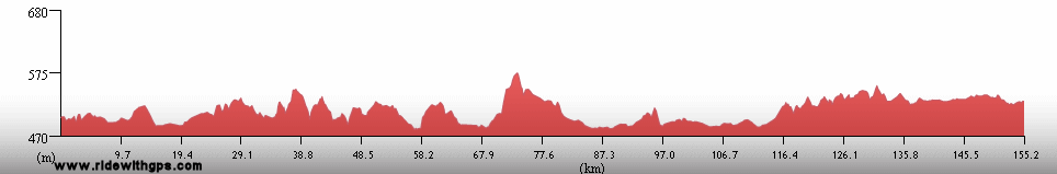
Stage 3: Occasional Water
Lakes, falls, and beasts
on the plateau
Stage 3 Actual Route
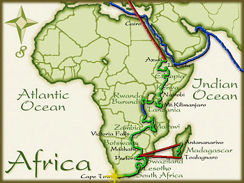
On this, and all other route maps, the blue lines represent travel by ship, red by airplane (Booo!), and green by bicycle.
Malawi: The Last Days in the Great Rift
Malawi was a country that I was very interested to visit. While not having many extraordinary sights, the whole country is rather beautiful and its people have a reputation for warmth and friendliness. I also knew that the infrastructure there would be fairly good over the route that I had chosen. The relatively small country is dominated by Lake Malawi, which runs along most of its eastern border. Because of that the lakeshore dominated most of my route. Before reaching the Lake, however, I needed to cross one section of rough terrain in the rural northwestern end of the country. That involved another day on a rather rough gravel road. Once at the lake, and turning south, the roadways were in good conditions for almost all of the rest of the route. I made two pleasant stops along the lake, the first at the pleasant village of Nkhata Bay, and later at Monkey Bay and Cape Maclear at the southern end of the lake. While at Cape Maclear, I took the opportunity to do a short dive in the Lake to see the endemic, and beautifully colored, Chiclids, a family of fish found only in the Rift Valley Lakes. From there I had only a short trip through Lilongwe, the capital, and then further west to the border with Zambia.
Information on Malawi appears in a post: ~HERE~
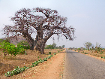
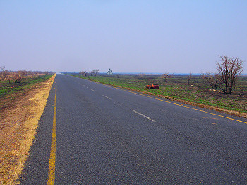
A big Baobab along the Lakeshore Highway
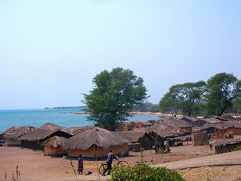
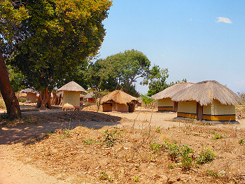
The village of Ngara on Lake Malawi
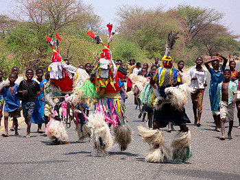
Traditonal Dancers followed by children
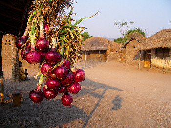
Onions and village buildings at Cape Maclear
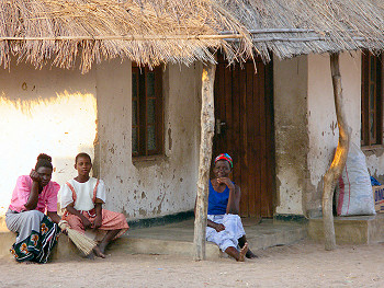
Villagers at Cape Maclear
Zambia: A Ride to the Gorge
I actually visited Zambia twice. The first of these was a rather short ride across the northern part of the country, between the port of Mplungu on Lake Tanganyika, to the northernmost border crossing with Malawi. That section was an unplanned part of my route, which I added as I thought that it would be shorter and easier than getting to Malawi via southern Tanzania. As it turned out, that was probably not the case, as the road between Kasame and Isoka, which I hope was a good road, was quite poor and slow. However, that area was quiet and pretty, though thinly populated. Though I was hoping to keep a rapid pace in that part of the Stage, I couldn't quite manage that under the conditions I found there.
My second visit to Zambia involved a rather straight route across the southern end of the country from the border town of Chipata to Livingstone. This part of the country was also thinly populated and there were not many exceptional places along the main highway. However, the terrain was easy and, in most places, the road was good. With the extra push from some nice tailwinds of the Eastern Trades, I had a rather easy time of it over this section. My only short stop was in the capital of Lusaka, a rather ordinary, but useful, city. I was there the day before the country's presidential election, and was very impressed by the long lines of voters I saw at the polls the following day. Continued easy conditions brought me to my primary destination while in the country, Livingstone and Victoria Falls. I arrived earlier than planned, and was able to rest and recover a little before visiting the Falls, In that regard, the water was as impressive as expected, though the Falls were not at their most mighty, as I was there during the dry season. In fat, in order to get the best view, I needed to cross over into Zimbabwe for a couple of hours, which turned out to be rather costly, as I needed a visa just for that purpose.
For a post on lonely Zambia look: ~HERE~
A small village in northern Zambia
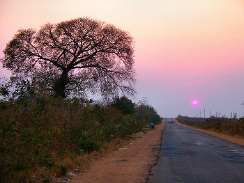
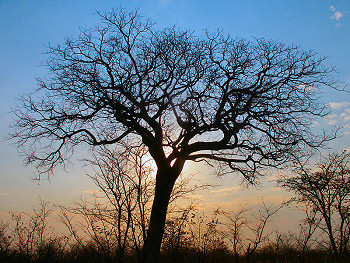
A Tree at Sunset
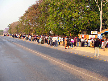
Voters line up during the Zambian Presidential Election
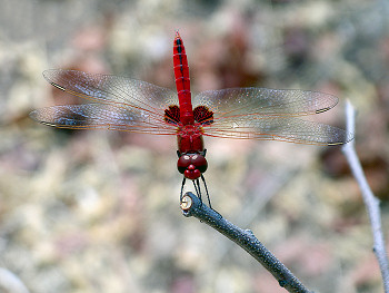
A Red Dragonfly
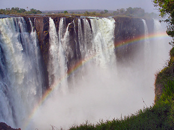
Victoria Falls
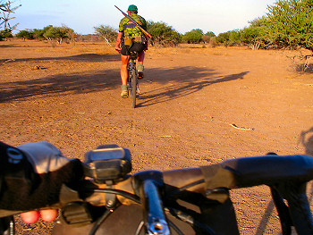
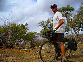
Botswana: Bicycling With Beasts
Botswana is another African country with a good reputation, but I knew that its lonely countryside would make things more difficult than they otherwise would have been. In many ways, much of the country resembles Outback Australia. Of course, I had a good time in the outback, and I knew I would enjoy Botswana too. My route was pretty straightforward. I entered the country after crossing the Zambezi River just west of Victoria Falls, and near the town of Kasane. The services there were good, which was fortunate, because the route from there crossed a long monotonous stretch of flat plains, with few services, for the next few days. Along the eastern edge of the country, the population picks up and I had an easy time in the vicinity of Francistown, Selebi-Phikwe, and Bobonong along the way to my main destination in the country, the Mashatu Game Reserve. That particular reserve was a place that I had planned on visiting since I originally started planning the Tour. The reason for that is that it is one of the few places in Africa where it is possible to go on a cycling safarai for game viewing. The opportunity to ride with the classic African wildlife was too good to pass up. I spent two days there, and went on two game rides, both of which were a lot of fun. The highlight was cycling along with elephants charging behind.
Botswana stories and details in this post : ~HERE~
A Tree in the early morning
The highway crosses a monotonous pan
Cycling Safari in Mashatu Game Reserve
Riding Mashatu
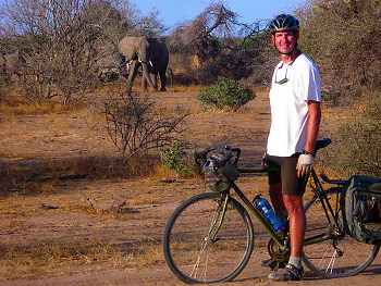
Me and the Mashatu Elephants
Previous | Next
Main Index | Pre-Tour Index
Post-Tour Index | Articles Index
Slideshows
Stage 3 Log
(continued)
For a description of terms and symbols look: ~HERE~
September 9, 02006
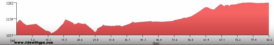
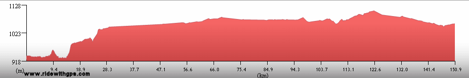
Mplungu to Ngolo
Distance: 159 km
Terrain: gradual 800-m climb; flat to light rolling
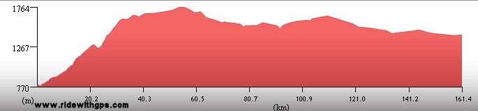
Max. Elevation: 1,745 m
Roads: M1
Max. Temp: 32 °C
Weather: Sunny; strong morning headwinds, becoming crosswind and diminishing slightly in afternoon
Accommodation:

Comment: A slow start to to winds on initial climb, but overall a productive day; wrist feels considerably better, but still far from 100%
September 10
Ngolo to 72 km E. of Kasama
Distance: 129 km
Terrain: Flat to light rolling
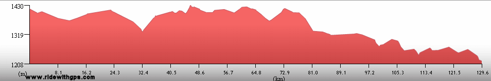
Max. Elevation: 1,430 m
Roads: M1, D18 (20 km paved, then fair to poor dirt [sandy])
Max. Temp: 31 °C
Weather: Sunny; moderate crosswinds
Accommodation:
Comment: A mixed day, easy start to Kasama, then disappointed by unexpected dirt road
September 11
72 km E. of Kasama to Isoka
Distance: 134 km
Terrain: Flat; light to moderate rolling with two small climbs
Max. Elevation: 1,575 m
Roads: D18 (fair dirt), T2
Max. Temp: 31 °C
Weather: Sunny; occasional light winds, various
directions
Accommodation:

Comment: Distance to Isoka 80 km longer than estimated; road slightly better condition than previous day
September 12
Isoka to Kanyala
Distance: 110 km
Terrain: Moderate rolling
Max. Elevation: 1,480 m
Roads: T2, RD69 (moderate to fair dirt, several sandy sections), M14 (moderate to poor dirt, rocky)
Max. Temp: 34 °C
Weather: Sunny; occasional light winds, various
directions
Accommodation:
Comment: Very late start after waiting around to exchange money; distance on dirt 60 km loger than estimated
September 13
Kanyala to Karonga, Malawi
Distance: 116 km
Terrain: Light to moderate rolling; moderate to heavy rolling; rolling 700-m descent (rough)
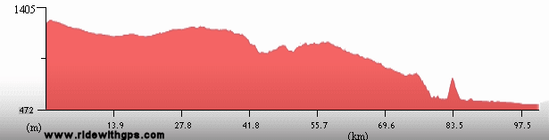
Max. Elevation: 1,130 m
Roads: RD69 (poor dirt), M26 (moderate to poor dirt/gravel, many sandy or corrugated sections, improving somewhat to the east; one 10-km paved section near Karonga)
Max. Temp: 33 °C
Weather: Sunny; very strong headwinds, diminishing in afternoon
Accommodation:
Comment: Much harder day than expected, from winds, sandy road, rolling terrain and wasted time due to a few leaky tubes; last long section of bad roads for a while over
September 14
Karonga to Chiweta
Distance: 123 km
Terrain: Flat to light rolling; 330-m climb
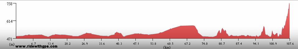
Max. Elevation: 860 m
Roads: M1
Max. Temp: 34 °C
Weather: Sunny; strong head/crosswinds, diminishing somewhat in afternoon
Accommodation:
Comment: Would have liked to have gone farther, but winds slowed progress
September 15
Chiweta to Nkhata Bay
Distance: 171 km
Terrain: 300-m climb/descent; light rolling, with gradual 540-m gain; moderate rolling; 800-m descent
Max. Elevation: 1,395 m
Roads: M1, M5
Max. Temp: 34 °C
Weather: Sunny; moderate tailwinds, becoming crosswinds in afternoon and diminishing
Accommodation:
Comment: Tailwinds just when needed most; but still a long day
September 16
Nkhata Bay
Accommodation:
Comment: Rest day in Nkhata Bay
September 17
Nkhata Bay to Dwangwa Estate
Distance: 145 km
Terrain: Light rolling
Max. Elevation: 644 m
Roads: M5
Max. Temp: 34 °C
Weather: Sunny; light tail/crosswinds in morning, diminishing in afternoon
Accommodation:
Comment: Late start, and delays due to failing rear tire and tube, but otherwise easy day
September 18
Dwangwa Estate to 15 km N. of Salima
Distance: 158 km
Terrain: Flat to light rolling
Max. Elevation: 625 m
Roads: M5
Max. Temp: 34 °C
Weather: Sunny; strong morning crosswinds, becoming tailwinds at
midday
Accommodation:
Comment: A fairly easy day, with jumbo winds
September 19
15 km N. of Salima to Monkey Bay
Distance: 162 km
Terrain: Light rolling; flat

Max. Elevation: 645 m
Roads: M5, M10 (moderate to excellent dirt, last 10 km paved)
Max. Temp: 32 °C
Weather: Mostly sunny; very strong headwinds through midday, occasional light crosswinds in afternoon
Accommodation:

Comment: A much harder day than expected, mostly from winds
September 20
Monkey Bay
Accommodation:
Comment: Rest/sightseeing day in Monkey Bay; visited Lake Malawi National Park, and did a dive at Cape Maclear
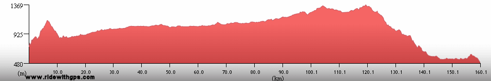
September 21
Lilongwe
Distance: 27 km
Accommodation:
Comment: Boat transfer across Lake Malawi to avoid duplicate ride over dirt road and to reach Lilongwe in one day; boat was very late and had to transfer to city via bus
September 22
Lilongwe
Accommodation:
Comment: Rest/repairs day in Lilongwe
September 23
Lilongwe to Chipata, Zambia
Distance: 155 km
Terrain: Light rolling to flat
Max. Elevation: 1,430 m
Roads: M12, Great East Rd. (Zamb.)
Max. Temp: 32 °C
Weather: Sunny; light tailwinds, becoming occasional
Accommodation:
Comment: First easy and problem-free day in weeks; could have gone considerably farther, but stopped to (unsuccessfully) do an errand in Chipata
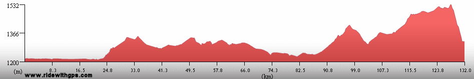
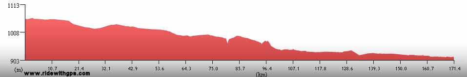
September 24
Chipata to 20 km W. of Petauke
Distance: 188 km
Terrain: Light rolling

Max. Elevation: 1,325 m
Roads: T4 (several short potholed/washed out/under repair section)
Max. Temp: 34 °C
Weather: Sunny; light cross/tailwinds, becoming occasional
Accommodation:
Comment: A long, but easy day
September 25
20 km W. of Petauke to 7 km E. of Luangwa Bridge
Distance: 153 km
Terrain: Light rolling; heavy to moderate rolling, with gradual 500-m elevation loss
Max. Elevation: 1,135 m
Roads: T4 (a little bumpy for 1st 30 km)
Max. Temp: 35 °C
Weather: Sunny; occasional light cross/tailwinds through morning
Accommodation:
Comment: Somewhat hotter and more hilly, but otherwise reasonable day, though would like to have gone a little farther
September 26
7 km E. of Luangwa Bridge to 35 km E. of Chongwe
Distance: 165 km
Terrain: Heavy to moderate rolling; gradual 700-m climb; 300-m descent; 300-m climb/descent; light to moderate rolling
Max. Elevation: 1,370 m
Roads: T4
Max. Temp: 33 °C
Weather: Sunny; occasional light tailwinds
Accommodation:
Comment: Tougher terrain than expected, but still a productive day
September 27
35 km E. of Chongwe to Lusaka
Distance: 83 km
Terrain: Light rolling
Max. Elevation: 1,420 m
Roads: T4
Max. Temp: 33 °C
Weather: Sunny; moderate tailwinds
Accommodation:
Comment: Easy half day to errands/rest break in Lusaka
September 28
Lusaka to Monze
Distance: 183 km
Terrain: Flat to light rolling; light to moderate rolling with gradual elevation loss/gain and one small hill; flat to light rolling
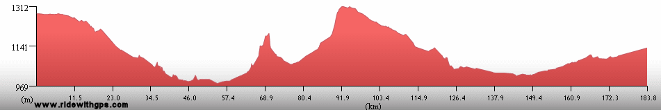
Max. Elevation: 1,425 m
Roads: T2, T1
Max. Temp: 32 °C
Weather: Overcast; moderate to stron tailwinds, becoming occasional light crosswinds in afternoon
Accommodation:
Comment: An easy and uneventfull day; many services closed for presidential election
September 29
Monze to Kalomo
Distance: 184 km
Terrain: Light rolling; flat to light rolling
Max. Elevation: 1,480 m
Roads: T1
Max. Temp: 32 °C
Weather: Partly cloudy; light to moderate tail/crosswinds
Accommodation:
Comment: Another fairly easy day
September 30
Kalomo to Livingstone
Distance: 121 km
Terrain: Light rolling
Max. Elevation: 1,380 m
Roads: T1 (one fairly long bumpy/potholed section)
Max. Temp: 33 °C
Weather: Mostly sunny; light tail/crosswinds
Accommodation:
Comment: Short day to long break in Livingstone; rode straight through to arrive early
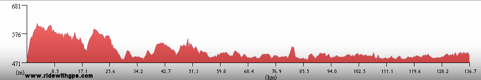
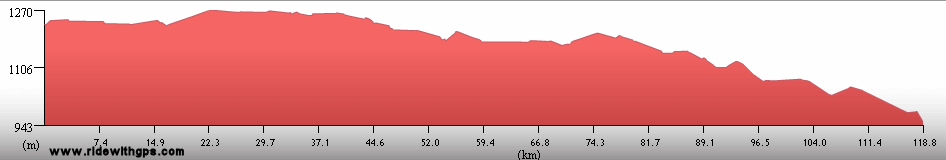
October 1
Livingstone
Accommodation:
Comment: Rest day in Livingstone; visited Livingstone Museum
October 2
Livingstone
Distance: 32 km
Accommodation:
Comment: Rest/sightseeing day in Livingstone; visited Victoria Falls (had to enter Zimbabwe)
October 3
Livingstone to Kasane, Botswana
Distance: 90 km
Terrain: Light rolling to flat
Max. Elevation: 1,180 m
Roads: M10; Kazungula-Ngoma Rd. (Botsw.)
Max. Temp: 34 °C
Weather: Cloudy through morning then partly sunny; light headwinds
Accommodation:
Comment: Decided to stop after half day as next section is longer than map indicated and to take care of errands
October 4
Kasane to 40 km S. of Pandamatenga
Distance: 154 km
Terrain: Flat to light rolling
Max. Elevation: 1,280 m
Roads: A33
Max. Temp: 36 °C
Weather: Mostly sunny; light cross/headwinds
Accommodation:
Comment: Felt rather tired, and an overall monotonous day; would like to have gone a little farther; saw several elephants
October 5
40 km S. of Pandamatenga to Nata
Distance: 170 km
Terrain: Flat to light rolling
Max. Elevation: 1,180 m
Roads: A33, A3
Max. Temp: 36 °C
Weather: Mostly sunny; light cross/headwinds
Accommodation:
Comment: Felt rather tired, and an overall monotonous day; would like to have gone a little farther; saw several elephants
October 6
Nata to Francistown
Distance: 188 km
Terrain: Flat

Max. Elevation: 1,130 m
Roads: A3
Max. Temp: 28 °C
Weather: Cloudy; strong to very strong headwinds
Accommodation:
Comment: Extremely tough, long day thanks to bad winds; arrived after dark; too much traffic on last 30 km
October 7
Francistown to 23 km E. of Serule
Distance: 113 km
Terrain: Light rolling to flat
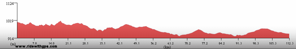
Max. Elevation: 1,000 m
Roads: A1, A15
Max. Temp: 33 °C
Weather: Sunny; light to moderate crosswinds
Accommodation:
Comment: Long half day after brief rest and unsuccessful attempts at errands in Francistown
October 8
23 km E. of Serule to 40 km S.E. of Bobonong
Distance: 166 km
Terrain: Flat to light rolling
Max. Elevation: 910 m
Roads: A15, B150, B151, Bobonong-Lokkerplat Rd.
Max. Temp: 33 °C
Weather: Sunny; light to moderate cross/headwinds
Accommodation:
Comment: A fairly easy day
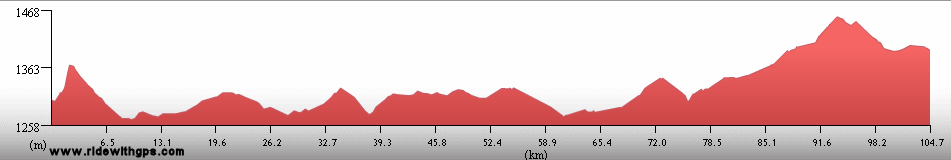
October 9
40 km S.E. of Bobonong to Mashatu Game Reserve
Distance: 63 km
Terrain: Light rolling
Max. Elevation: 650 m
Roads: Bobonong-Lokkerplat Rd., Motlhabaneng Rd. (good dirt/gravel), Mashatu Rd. (fair to good dirt)
Max. Temp: 32 °C
Weather: Sunny; moderate head/crosswinds
Accommodation:
Comment: Half day to safari break at Mashatu; distance 16 km longer than map indicated
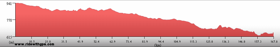
October 10
Mashatu Game Reserve
Distance: 28.6 km
Accommodation:
Comment: Cycling safari at Mashatu; rode with elephants
Continued on Next Page
Index | Next Page
Pre-Tour Stage 1 Stage 2 Stage 3 Stage 4 Stage 5 |