
Stage 4: The Continent's Cap
Mountains until the very end
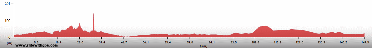
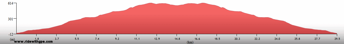
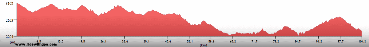
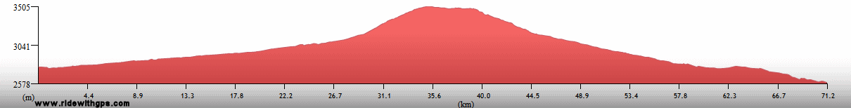
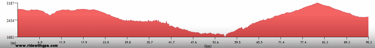
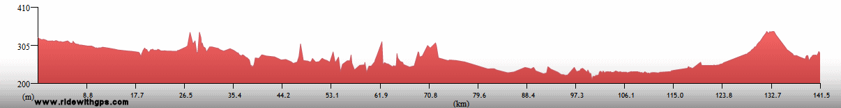
Stage 4 Actual Route

On this, and all other route maps, the blue lines represent travel by ship, red by airplane (Booo!), and green by bicycle.
Islas Galapagos: My Vacation from the Tour
An unplanned addition to my Stage 4 plan was a fascinating visit to the Islas Galapagos, off the Ecuadorian coast. I decided to visit the islands primarily because I was attracted by their collection of unique flora and fauna, but also because I felt they would provide a nice break from the rigors of the Stage up to that point. While there is only a tiny infrastructure usable for cycling on the archipelago, I took the bike along with me anyway, and was able to go for some fun day rides on the minimal road networks of the three main inhabited islands. Namely, Santa Cruz, the most developed, where the highlight was seeing Giant Tortoises in the wild; Isabela, the largest, and in my mind, the most beautiful island, which was intensely relaxing; and San Cristobal, where the islands capital is located. While I was there I also took several day tours to the smaller islands, including Bartolome, with its famous volcanic vistas, and Santa Fe, which boasts a species of iguana endemic to that specific island. While the extra cost and time required to make that visit would surely cause problems later on, I was decidedly glad that I went, and was satisfied that I achieved my goal of seeing as many of the special creatures there as I possibly could.
Some additional details in this post: ~HERE~

Baia Sullivan, Pinnacle Rock, Islas Bartolome and Santiago

A Marine Iguana on Tortuga Beach

A Swallow-Tailed Gull

A male Magnificent Frigatebird in courtship display

Volcan Chico vents on Volcan Sierra Negro, Isla Isabela

Marine Iguanas check out my bike

A Santa Fe Land Iguana, endemic to Isla Santa Fe

A Santa Cruz Giant Tortoise, Isla Santa Cruz

Charles Darwin Statue on Isla San Cristobal
Ecuador: Goodbye Southern Hemisphere
Ecuador was another country that contained a variety of interesting places crammed into a rather small country. While I did not get to see everything, and the weather made what I did see a little less impressive than what it might otherwise have been, I certainly enjoyed my visit a great deal. I entered at the southern border with Peru, once the scene of squabbles and conflicts between the two countries. A brief section of the route in the verdant, steamy coastal lowlands brought me to the port city of Guayaquil, which I used as my departure point for the Galapagos. Upon my return, a final climb into the high Andes came straight away, though it was a decidedly slow and damp effort. At the end of that climb was the historic town of Cuenca, at that point I turned north, and the rest of the route through the country followed the spine of the central sierras to the northern border. Interesting events along that section included a my futile attempt to cross an old volcanic zone, and a very pleasant stay in the capital, Quito, whose historic center was probably my favorite of the Stage. Just to the north of the city, the momentous crossing of the Equator at the Mitad del Mundo monument brought and end to my time in the southern hemisphere, a bittersweet occasion indeed. After that, remained only a fairly short distance to the border with Colombia, with the highlight being the nice little town of Otavalo, with its extensive crafts market and resident's unique attire.
A post with the rest of the story: ~HERE~

The Malecon in Guayaquil

The Molleturo Valley; Climbing back into the Andes

Alpine flowers high in the Andes

Cuenca flower market

The bike resting on a Lahar near Volcan Tungarahua

Historic Center of Quito

Iglesia San Francisco, Quito

Iglesia de Compania, Quito

Guests at a wedding in Otavalo

Crossing the Equator, leaving the Southern Hemisphere for good
Colombia: An Uncommon Country
Another country that I added to the Stage route once the Tour was underway was Colombia. My previous experiences during the Tour had formed my belief that places which exuded a sensation of fear in mainstream thought were almost certainly not as bad as they are perceived to be. Though I was still cognizant of the country's current and past conflicts, my tour there went of without a hitch. I entered, crossing from Ecuador, at the southern town of Ipiales. The landscapes in that region were among the most rugged, but also the most beautiful, of the Stage, and, with a considerable effort, I rode across the area's mountain passes, and through the cities of Pasto and Popayan. The latter possesses a beautiful historic district, and I was fortunate that my visit there coincided with the annual Semana Santa festivities. After a nice rest in that town, a rough crossing of one final high mountain pass brought me to the valley of the Rio Magdalena, the central corridor of the country, and its two archeological sites, at San Agustin, and Tierradentro. Those mysterious sites exhibited a distinct feel from the others in countries further south, and I was glad I saw them, though I did not have enough time to reach the latter by bike.
With time in the Stage running short, I was forced to pick up the pace thought the rest of the country. With that in mind, I made as direct a run as possible up the Magdalena Valley, without taking the time to visit any of the attractions in the mountains on either side. One final visit, however, was to the very out-of-the-way colonial town of Santa Cruz de Mompox, located in the center of the broad wetlands surrounding the Magdalena, and which proved to be a bit of a chore to reach given the amount of time I had left. However, after that visit, I successfully arrived at the Stage's official end point, the energetic city of Cartageña. Its historic city, forts, and beaches, as well as its easy options for transfers to Stage 5, made that city an ideal place at which to finish up the Stage. Though there were still a few places on the continent I would have enjoyed seeing, Stage 4, the longest of the Tour, by far, brought me to all the important areas of the continent, with much more complete coverage than other three Stages, and was a huge success, as far as I was concerned.
Summing up the Stage with this post: ~HERE~

Rio Patia Gorge near Pasto

A man selling Hats in El Bordo

Popayan, the White City

Semana Santa Procession in Popayan

Mysterious stone statues in San Agustin Archeological Park

Rio Madgalena

An Orange-Winged Amazon

A man and his burro in Santa Cruz de Mompox

Cartagena Viejo; End point for Stage 4
Dates and Distances
Start: February 19, 02007
Finish: April 1, 02008
Actual Distance: 28,157 km
Ride days: 204
Rest days: 204
Highest Point
4,550 meters: Abra Condorcenca, Peru
Previous | Next
Main Index | Pre-Tour Index
Post-Tour Index | Articles Index
Slideshows
Stage 4 Log
(continued)
For a description of terms and symbols look: ~HERE~
February 6, 02008
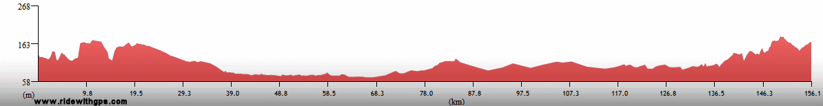
Huaquillas to Naranjal
Distance: 151 km
Terrain: Flat to light rolling
Max. Elevation: <300 m
Roads: E25 (many damaged/rough sections, most during first 50 km, some under construction)
Max. Temp: 29 °C
Weather: Cloudy; occasional mild headwinds in afternoon
Accommodation:

Comment: A fairly easy day, but unpleasantly heavy and incompetent traffic in afternoon
February 7
Naranjal to Guayaquil
Distance: 111 km
Terrain: Flat
Max. Elevation: <300 m
Roads: E25, GY11
Max. Temp: 29 °C
Weather: Cloudy; mild to light headwinds
Accommodation:
Comment: A short, but tedious day to Guayaquil; last several kms on very busy expressways and difficult to navigate; hoped to arrange visit to Galapagos in afternoon, but boat options uncertain
February 8
Guayaquil
Accommodation:
Comment: Errands day in Guayaquil; couldn't work out sea transfer to Galapagos, will have to fly instead
February 9
Guayaquil
Accommodation:
Comment: Delay in Guayaquil waiting for flight; made some repairs
February 10
Puerto Ayora, Isla Santa Cruz
Distance: 48 km
Terrain: 600-m climb/descent
Max. Elevation: 600 m
Roads: Baltra Island Rd., Canal de Itabaca Ferry, Santa Cruz Island Rd.
Max. Temp: 27 °C
Weather: Cloudy, periods of rain
Accommodation:
Comment: Morning air transfer to Galapagos Islands; short, but damp, ride to Puerto Ayora
February 11
Puerto Ayora
Accommodation:
Comment: Rest/tour planning day in Puerto Ayora; visited Charles Darwin Research Center
February 12
Puerto Ayora
Accommodation:
Comment: Sightseeing day; day tour to North Seymore Island
February 13
Puerto Ayora
Accommodation:
Comment: Sightseeing day; day tour to Bartolome Island
February 14
Puerto Ayora
Accommodation:
Comment: Rest day in Puerto Ayora
February 15
Puerto Villamil, Isla Isabela
Accommodation:
Comment: Morning walk to Tortuga Bay beach; afternoon boat transfer to Isabela Island, very bumpy
February 16
Puerto Villamil
Accommodation:
Comment: Sightseeing day on Isabela; visited Tortoise Breeding center, and hike/snorkeling on Las Tintoreras Islets
February 17
Puerto Villamil
Accommodation:
Comment: Sightseeing Day on Isabela; Sierra Negra Volcano hike/horseback tour
February 18
Puerto Villamil
Distance: 57 km
Terrain: 718-m climb/descent; flat
Max. Elevation: 720 m
Roads: Highlands Rd. (excellent to fair gravel), Beach Rd (fair to poor gravel/sand)
Accommodation:
Comment: Sightseeing day by bike on Isabela; rode back to Sierra Negra highlands and on beach road to Wall of Tears
February 19
Puerto Villamil
Accommodation:
Comment: Sightseeing day on Isabela; diving at Islote Tortuga
February 20
Puerto Ayora
Accommodation:
Comment: Morning boat transfer to Santa Cruz Island; boat tour to Santa Fe Island
February 21
Puerto Baquerizo Moreno
Distance: 51 km
Terrain: 600-m climb/descent
Max. Elevation: 600 m
Roads: Santa Cruz Island Rd.
Accommodation:
Comment: Morning cycling tour on Isla Santa Cruz; visited Los Gemelos sinkholes, Giant Tortoise Reserve, and lava tunnels at Bellavista; afternoon boat transfer to Isla San Cristobal
February 22
Puerto Baquerizo Moreno
Distance: 31 km
Terrain: 625-m climb/descent
Max. Elevation: 625 m
Roads: El Progresso Rd.
Accommodation:
Comment: Sightseeing day on San Cristobal; morning hike and afternoon ride to highlands
February 23-25
Guayaquil
Accommodation:
Comment: Air transfer to Guayaquil; two more rest days
February 26
Guayaquil to 12 km E. of Puerto Inca
Distance: 77 km
Terrain: Flat
Max. Elevation: <300 m
Roads: GY11, E25, El Caja Hwy.
Max. Temp: 34 °C
Weather: Mostly cloudy through morning, then partly sunny; huge cloudburst in afternoon
Accommodation:

Comment: Half day after very late start and delay due to big storm; planned on going considerably farther; used taxi to exit city and avoid horrible highway/bridge
February 27
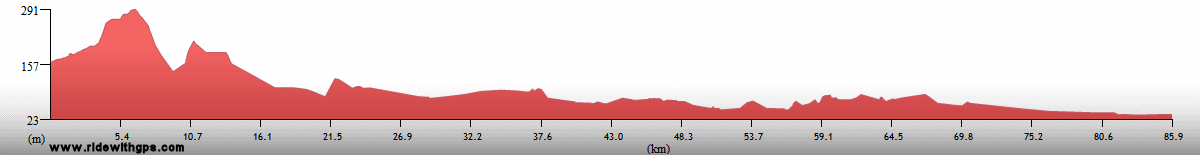
12 km E. of Puerto Inca to Molleturo
Distance: 47 km
Terrain: 2,600-m climb (incomplete); 300-m descent

Max. Elevation: 2,740 m
Roads: El Caja Hwy. (many rockslides, mudslides, and washed out sections, especially during 1st 25 km, improving later)
Max. Temp: 25 °C
Weather: Cloudy, periods of mist/drizzle/light rain, becoming steady in afternoon
Accommodation:
Comment: A rather grim day; road problems slowed progress only slightly; clouds and fog obscured scenery; temperature dropped rapidly during climb; made needed progress in any case
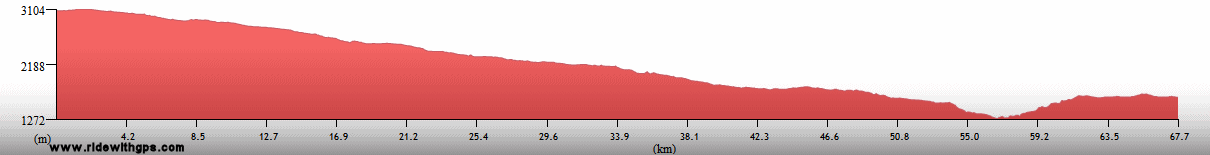
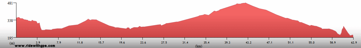
February 28
Molleturo to Cuenca
Distance: 70 km
Terrain: 1,600-m climb; 1,500-m descent
Max. Elevation: 4,026 m
Roads: El Caja Hwy. (some rock/mudslides, but better on east side of pass)
Max. Temp: 14 °C
Weather: Mostly cloudy; light rain/drizzle at midday, drier on east side of pass
Accommodation:
Comment: A short, but slow day; cold and damp; last time above 4k meters for the tour
February 29
Cuenca
Accommodation:
Comment: Rest/sightseeing day in Cuenca; visited historic city center
March 1
Cuenca to Canar
Distance: 71 km
Terrain: Light rolling, with slight descent/gain; 1,040-m climb; 400-m descent
Max. Elevation: 3,480 m
Roads: E35
Max. Temp: 25 °C
Weather: Mostly cloudy through mid-morning; partly sunny; cloudy/foggy in late afternoon; light headwinds at top of big climb
Accommodation:
Comment: Had planned a full day, but instead stopped at Canar after a slow half day; visited Inca ruins at Ingapirca
March 2
Canar to Aluasi
Distance: 104 km
Terrain: Hilly, 300-m climb/descent
Max. Elevation: 3,080 m
Roads: E35 (25 km section of fair dirt/gravel)
Max. Temp: 19 °C
Weather: Partly cloudy, foggy in afternoon, with thick patches
Accommodation:
Comment: Sluggish start, and tougher terrain than expected
March 3
Aluasi to Riobamba
Distance: 94 km
Terrain: 1,160-m climb (broken by short descent); hilly; light to heavy rolling; 440-m climb/descent
Max. Elevation: 3,535 m
Roads: E35, Guamote-Riobamba Cut-off (fair dirt/gravel, good pavement during descent, then bumpy)
Max. Temp: 23 °C
Weather: Partly to mostly cloudy
Accommodation:
Comment: Another slow day; much more climbing than expected; short-cut did not save distance or time, and included another unexpected climb
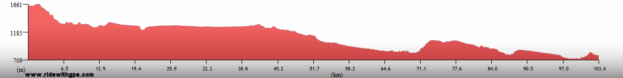
March 4
Riobamba
Distance: 68 km
Terrain: 300-m descent; moderate rolling
Max. Elevation: 2,947 m
Roads: Riobamba-Banos Rd. (1st 40 km paved, then road disintegrated due to past volcanic eruptions, eventually disappearing)
Max. Temp: 14 C
Weather: Cloudy
Accommodation:
Comment: A wasted day; couldn't get useful information on condition of Banos road, but decided to try that route anyway; spent several hours walking across old volcanic lahar, but couldn't cross final gorge; had to return to Riobamba
March 5
Riobamba to Latacunga
Distance: 103 km
Terrain: 785-m climb; 440-m descent; moderate rolling, with small descents and one small climb; light rolling
Max. Elevation: 3,735 m
Roads: E35
Max. Temp: 22 °C
Weather: Partly to mostly cloudy in morning, cloudy in afternoon with 2 periods of light rain/drizzle
Accommodation:
Comment: Another short day, relatively easy, though climb longer than expected
March 6
Latacunga to Amaguana
Distance: 75 km
Terrain: 740-m climb (1st half very gradual); 400-m descent
Max. Elevation: 3,660 m
Roads: E35
Max. Temp: 17 °C
Weather: Cloudy; periods of light rain/drizzle after midday
Accommodation:
Comment: A chilly, damp half day; took shuttle for last 25 km into Quito to avoid heavy traffic in rain
March 7
Quito
Accommodation:
Comment: Sightseeing day in Quito; visited historic city center and National Museum
March 8
Pomasaqui to Tabacundo
Distance: 73 km
Terrain: Moderate rolling; 330-m climb (rough); 680-m descent; one small climb/descent; 790-m climb
Max. Elevation: 3,125 m
Roads: Local Roads, Pomasqui-Calderon Cut-off (poor dirt/rock), E35, E282
Max. Temp: 22 °C
Weather: Cloudy
Accommodation:
Comment: Taxi to northern edge of Quito to avoid bad urban conditions; planned on going considerably father, but stopped early after a slow start and tougher terrain than expected; distance includes ~15 km to visit Equator monument in San Antonio
March 9
Otavalo
Distance: 31 km
Terrain: small climb; 400-m descent; moderate rolling
Max. Elevation: 3,220 m
Roads: Tabacundo Cut-off, E35
Accommodation:
Comment: Short ride to rest break in Otavalo; visited crafts market
March 10
Otavalo to San Gabriel
Distance: 111 km
Terrain: Light rolling, with gradual 350-m decline; 600-m descent; moderate to light rolling; 1,000-m climb; moderate rolling with small elevation gain
Max. Elevation: 3,235 m
Roads: E35
Max. Temp: 29 °C
Weather: Mostly cloudy; moderate showers followed by drizzle/light rain in late afternoon
Accommodation:
Comment: Would have liked to go somewhat farther, but big climb and rain prevented that
March 11
San Gabriel to Ipiales, Colombia
Distance: 57 km
Terrain: rolling 430-m climb; 300-m descent; heavy rolling

Max. Elevation: 3,360 m
Roads: E35, Hwy 25 (Col.)
Max. Temp: 22 °C
Weather: Mostly sunny through morning, mostly cloudy in afternoon, showers in late afternoon
Accommodation:
Comment: Leisurely half day to Ipiales; border very congested, but was able to ride around traffic
March 12
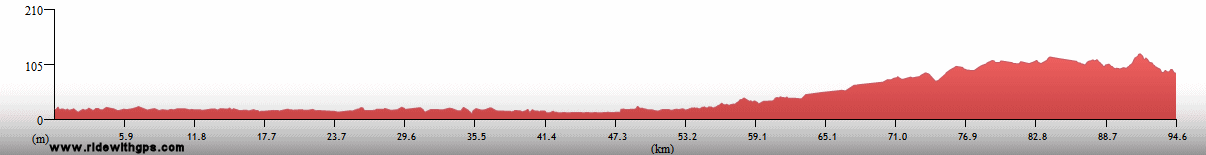
Ipiales to Pasto
Distance: 99 km
Terrain: 1,110-m descent, broken by one long, and a few short, rolling sections; 1,380-m climb; 610-m descent (somewhat bumpy)
Max. Elevation: 3,250 m
Roads: Hwy 25
Max. Temp: 27 °C
Weather: Cloudy through morning; mostly sunny in early afternoon; mostly cloudy later; thundershower in area, but no rain on route
Accommodation:
Comment: A reasonable, though slow day due to climb; distance includes extra 12 km (and 1 small descent/climb) to visit sanctuary at Las Lajas
March 13
Pasto
Distance: 19 km
Weather: Cloudy; light rain through morning
Accommodation:
Comment: Started ride, bit did not want to do big descent in wet conditions and returned to Pasto
March 14
Pasto to Mojarras
Distance: 125 km
Terrain: 300-m climb; 1,900-m descent (bumpy near top); 640-m climb; 800-m descent; hilly to moderate rolling
Max. Elevation: 2,820 m
Roads: Hwy 25 (several bumpy/rough sections and a couple slides)
Max. Temp: 27 °C
Weather: Mostly to partly cloudy; 3 periods of light rain
Accommodation:
Comment: A significantly tougher day than expected; wanted to go considerably further, but big descent not as fast as hoped; some nice scenery
March 15
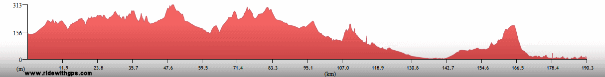
Mojarras to Popayan
Distance: 127 km
Terrain: Moderate to heavy rolling; 300-m climb; heavy rolling; small descent; 820-m climb; 370-m descent; 480-m climb; heavy rolling
Max Elevation: 1,890 m
Roads: Hwy 25 (several small collapsed places)
Max. Temp: 31 °C
Weather: Partly cloudy
Accommodation:
Comment: A generally pleasant day, but with somewhat more climbing than expected, very slow; arrived just after dark; first day in weeks with reasonable weather through whole day; some great scenery
March 16-17
Popayan
Accommodation:
Comment: Rest/sightseeing days in Popayan; visited historic city center; watched Semana Santa procession
March 18
Popayan to Parque Nacional Purace
Distance: 74 km
Terrain: 1,270-m climb (broken by a few short descents near start; rough after 30 km); moderate to light rolling; one small climb; moderate rolling
Max. Elevation: 3,175 m
Roads: Hwy 20 (1st 30 km paved, then fair to poor gravel/dirt)
Max. Temp: 23 °C
Weather: Mostly sunny through morning, then mostly to partly cloudy; occasional light headwinds
Accommodation:

Comment: Road condition not quite as bad as feared (worst sections in National Park), but slow progress nonetheless; had hoped to go somewhat farther
March 19
Parque Nacional Purace to San Agustin
Distance: 74 km
Terrain: Rolling 1240-m descent (rough); light rolling; 490-m descent (last 2 km rough); 450-m climb
Max. Elevation: 3,118 m
Roads: Hwy 20 (1st 45 km poor to fair dirt/gravel, then paved, final 2 km fair gravel), San Agustin Rd
Max. Temp: 31 °C
Weather: Mostly cloudy in morning, then partly sunny
Accommodation:
Comment: Slow half day to San Agustin; visited San Agustin archeological park
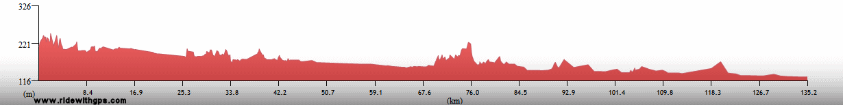
March 20
San Agustin to Garzon
Distance: 110 km
Terrain: 440-m descent; flat to moderate rolling, with several small climbs/descents
Max. Elevation: 1,740 m
Roads: Hwy 45
Max. Temp: 34 °C
Weather: Mostly cloudy at morning, becoming partly sunny
Accommodation:
Comment: A rather short, but reasonably pleasant day; back sore after slipping in mud on previous day, made riding uncomfortable; drivetrain really skipping on climbs
March 21
Garzon
Accommodation:
Comment: Sightseeing day in Garzon area; day tour to Tierradentro archeological site
March 22
Garzon to Neiva
Distance: 117 km
Terrain: Moderate rolling, with one small climb and 340-m descent; moderate rolling to flat
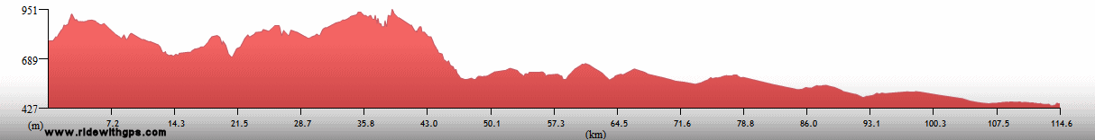
Max. Elevation: 1,070 m
Roads: Hwy 45
Max. Temp: 31 °C
Weather: Cloudy in morning, partly sunny in afternoon
Accommodation:
Comment: A short and easy day; could have gone considerably farther, but stopped to take care of a few errands
March 23
Neiva to Espinal
Distance: 158 km
Terrain: Moderate rolling; light rolling to flat
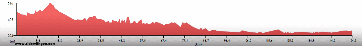
Max. Elevation: 685 m
Roads: Hwy 45
Max. Temp: 35 °C
Weather: Mostly cloudy in morning, partly sunny in afternoon; light tailwinds in early afternoon
Accommodation:
Comment: Another relatively easy, though rather uninteresting day; first day with full distance in quite a while
March 24
Espinal to Lerida
Distance: 149 km
Terrain: Flat to light rolling; 3 small climbs and 2 small descents
Max.Elevation: 560 m
Roads: Hwy 45, Giridot-Beltran Rd., Rio Magdalena Ferry, Ambalema Rd., Hwy 43
Max. Temp: 35 °C
Weather: Sunny
Accommodation:
Comment: A generally nice day; nice backroad along Rio Magdalena; map not very accurate
March 25
Lerida to Honda
Distance: 64 km
Terrain: Light rolling; one gradual small climb/descent
Max. Elevation: 460 m
Roads: Hwy 45, Hwy 50
Max. Temp: 37 °C
Weather: Sunny
Accommodation:
Comment: Unplanned half day; feeling tired and hot and stopped early
March 26
Honda
Accommodation:
Comment: Could not ride due to food-caused illness
March 27
Honda to El Cruce Serviez
Distance: 135 km
Terrain: Light rolling to flat; moderate rolling; light to moderate rolling
Max. Elevation: <300 m
Roads: Hwy 45
Max. Temp: 34 C
Weather: Cloudy in morning, then hazy sun; occasional mild to light headwinds
Accommodation:
Comment: Not feeling 100%, but rode anyway; would have liked to go somewhat farther, but too sluggish for that; surprisingly heavy traffic, with too many trucks
March 28
El Cruce Serviez to La Lizama
Distance: 161 km
Terrain: Light rolling to flat; moderate rolling to flat
Max. Elevation: <300 m
Roads: Hwy 45, Hwy 45/66
Max. Temp: 33 °C
Weather: Heavy rain at sunrise, lighter later at start of ride, then cloudy, becoming hazy sun by late afternoon
Accommodation:
Comment: Still feeling very sluggish through morning, but a little better in afternoon; Brazilian-Style road very annoying, especially with poor condition of 1st 60 km; did accomplish needed distance
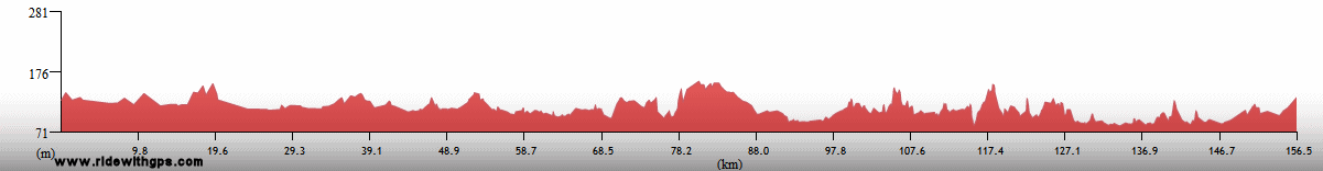
March 29
La Lizama to Aguachica
Distance: 160 km
Terrain: Light rolling to flat; flat; moderate to light rolling
Max. Elevation: <300 m
Roads: Hwy 45 (most of final 70 km narrow with too much traffic)
Max. Temp: 33 °C
Weather: Cloudy to mostly cloudy; light headwinds, increasing in afternoon
Accommodation:
Comment: A very tedious and uninteresting day
March 30
Aguachica to Tamalameque
Distance: 89 km
Terrain: Hilly to heavy rolling; flat
Max. Elevation: <300 m
Roads: Hwy 45, Rd. 78 (poor to fair dirt/gravel)
Max. Temp: 33 °C
Weather: Mostly cloudy; occasional light winds, various directions
Accommodation:
Comment: A reasonably good start, but did not feel like continuing on bad road; short bus transfer to El Banco
March 31
Mompox to San Pedro
Distance: 95 km
Terrain: Flat; light to moderate rolling with slow elevation gain
Max. Elevation: <300 m
Roads: Hwy 78 (some heavily potholed sections), Rio Magdalena speedboat ferry, Hwy 78
Max. Temp: 32 °C
Weather: Cloudy to mostly cloudy
Accommodation:
Comment: Morning transfer to Mompox to skip last section of bad road; would have preferred to go considerably farther, but delayed start and river crossing slowed progress; quickly visited historic center of Mompox; last day of stage will need to be a long one
April 1
San Pedro to Cartagena!
Distance: 196 km
Terrain: Heavy rolling to hilly; flat; moderate to heavy rolling
Max. Elevation: <300 m
Roads: Hwy 78, Hwy 25, Hwy 25B, Hwy 90, Local Rds.
Max. Temp: 31 °C
Weather: Cloudy, partly sunny in afternoon, with one brief light shower; light tailwinds
Accommodation:
Comment: End of Stage 4!!
Index | Next Page
Pre-Tour Stage 1 Stage 2 Stage 3 Stage 4 Stage 5 |