
Stage 4: The Continent's Roof
Breathtaking heights and
ancient sites at every turn
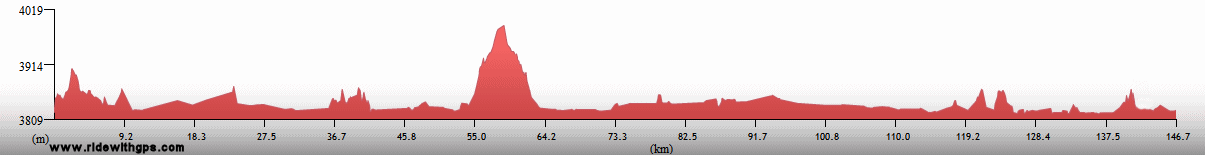
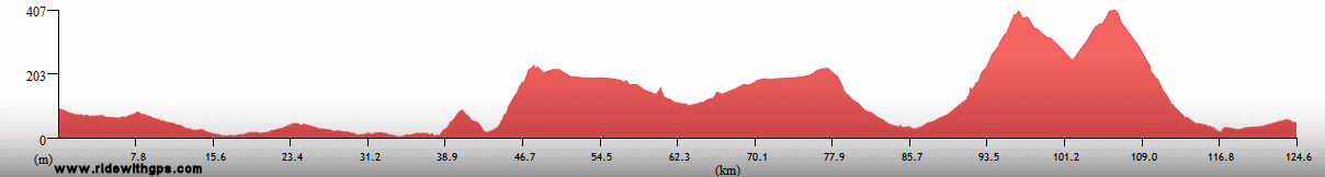
Stage 4 Actual Route

On this, and all other route maps, the blue lines represent travel by ship, red by airplane (Booo!), and green by bicycle.
Argentina: Iguazu, Chaco, & Andes
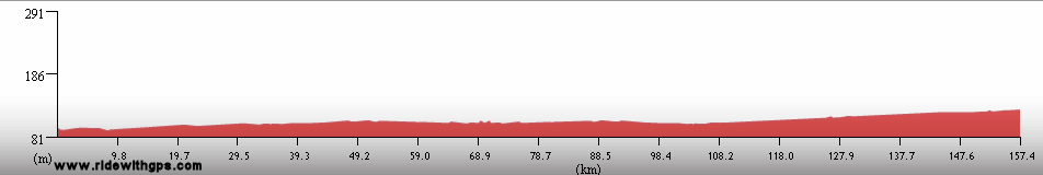
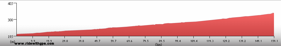
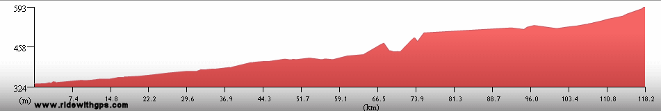
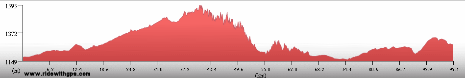
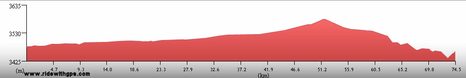
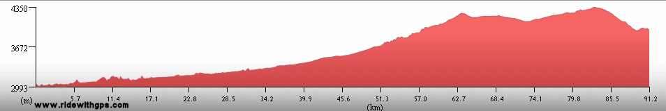
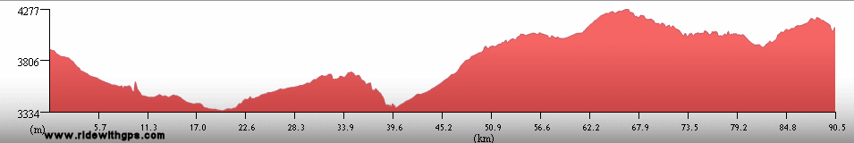
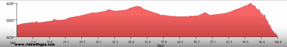
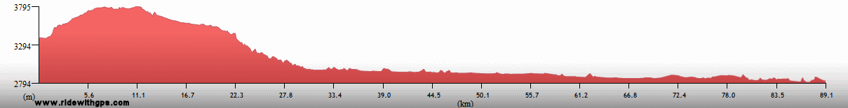
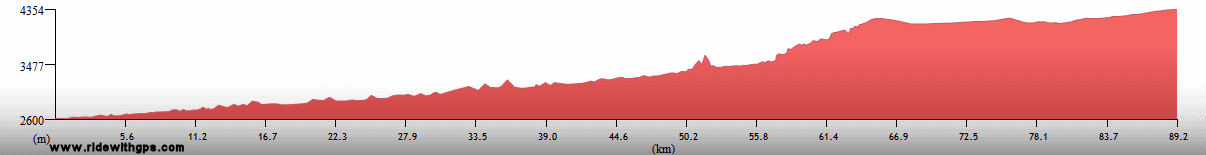
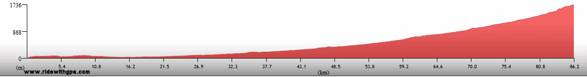
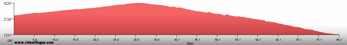
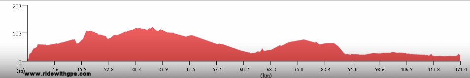
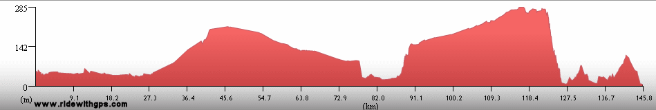
One final section in Argentina came next, almost nine months after I first entered that country. In that case, I traversed the far north of the country, starting in the semi-tropical region around Iguazu, then, after a drastic change of environments, I crossed The Chaco, a semi-arid region, where the early days of spring had already increased the local temperature to a level well above what I encountered in my earlier visits. A final, distinct, region came as I began the climb into the Andes, in the vicinity of the regional capital, Salta, for what would be an extended stay in that high-altitude region. Highlights along the route included, of course, the spectacular Iguazu Falls and the beautiful national park surrounding it, another ruined Jesuit mission at Santa Ana, and the generally incredible scenery in the mountains. The best of the latter was in the gorge known as the Quebrada de Humahuaca, which has been used as a trade and transport route for millennia.
The last words from Argentina in this post: ~HERE~

Iguazu Falls

Iguazu Falls

A Plush-Crested Jay

Salta Cathedral

Quebrada de Humahuaca

The Altiplano in the far northwest

Three Llamas
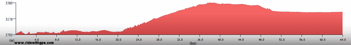
Bolivia: Splendor of the Altiplano
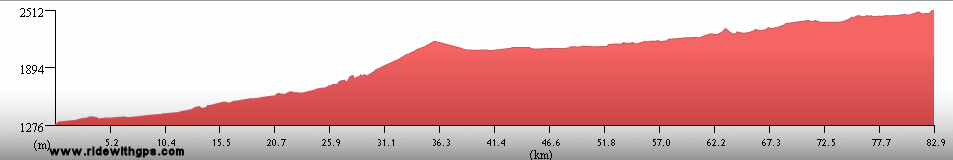
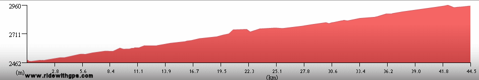
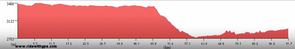
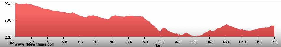
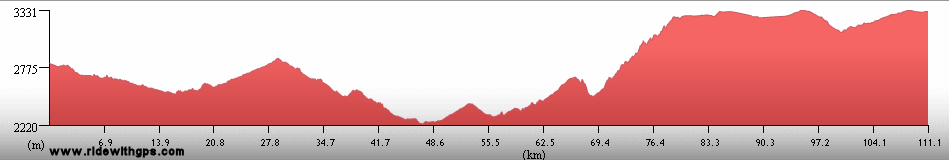
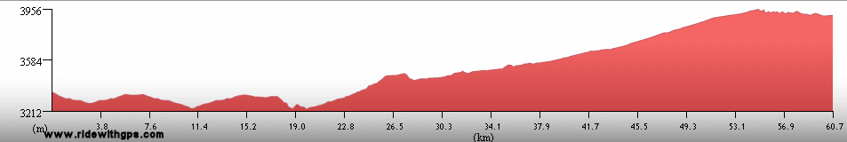
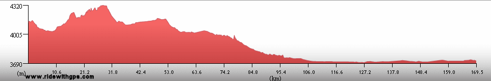
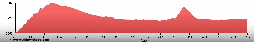
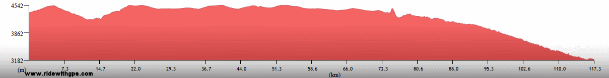
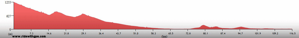
Bolivia gave me exactly what I needed to start the second half of the Stage. Namely, great cycling conditions for much of the time, an abundance of terrific natural vistas, and a colorful and fascinating culture. For overall day-to-day experiences, it was hard to beat Bolivia as a touring destination. My visit, on this Tour, was confined to the high Altiplano region of the country, which was fine for me, as that type of environment was just the thing for me after a long stretch in the eastern part of the continent. I entered in the far south, at the little border town of Villazon, and continued northward, with the disposition of the next several days being defined by the usually-poor road that ran north though the Tupiza region. From there, I eventually reached the fascinating and historic neighboring cities of Potosi and Sucre, and my visits there provided me with a mix of interesting sites, vibrant local traditions, and political tensions. Continuing northward, the center of the country, predominantly high plateau country, gave me the opportunity to progress without needing to deal with many unexpected circumstances, a rarity for the previous few months.
That uneventful section of the route brought me to La Paz, which as had I remembered learning when I was much younger, is the highest capital city in the world. I spent a short break there to catch my breath, and then ended the route through the country with visits to a few of its finest attractions. The first of those was to the Tiwanaku archeological site, which was once the center of a great pre-Inca society. The country's final highlight, one of my favorites, was the area around Lake Titicaca, a place that I had thought about visiting since I was a young boy. I was blessed with perfect weather while I was there, which made the sights of the area that much more impressive. Those included the famous Basilica at Copacabana, and the Isla del Sol and Isla del Luna on the lake itself. I certainly would not have minded spending considerably more time in the country, as there was still more to see, but time, however, was already starting to run short for the Stage.
A post filled with many happenings: ~HERE~

El Angosto gorge near Tupiza

The Tupiza Road winds through the Tumusla Valley

Potosi and Cerro Rico

Procession for the Virgen de Candelaria in Potosi

Ladies in Potosi

Witch's Market in La Paz

Ponce Monolith at Tiwanaku Ruins

Basilica de Copacabana

Woman with a Llama on Isla del Sol

Lake Titicaca
Peru: Every Conceivable Environment
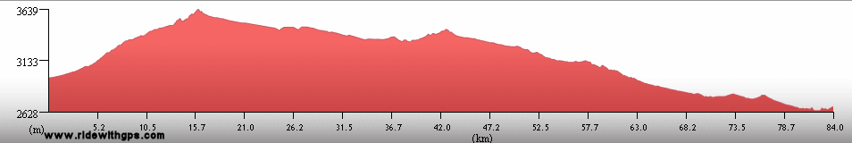
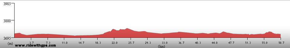
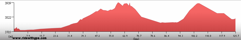
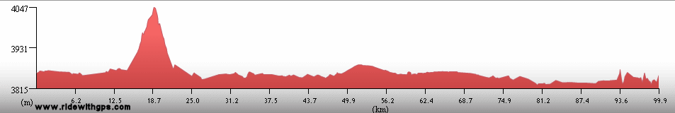
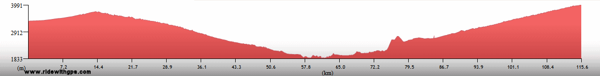
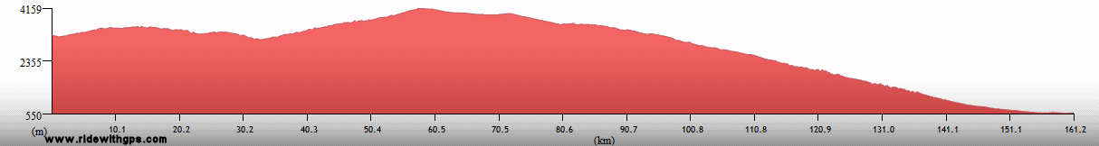
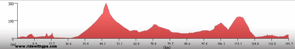
My favorite locations for Touring usually exhibit a wide variety of environments that can be experienced in a single tour. Peru, probably outshines all of the other countries of the Tour in that regard. In addition to its varied environs, the country also contained such a great number of historic and cultural sites that it became difficult to maintain a reasonable pace for the ride. My tour through the country took place in three distinct zones, beginning with the Andean region in the south, and then progressing to the coastal desert areas along the central and northern coasts, a section that was bisected by an interesting side-trip to the Amazon basin and the isolated jungle city of Iquitos.
The Andean portion of the route truly was spectacular, and the impressive sights began right away. Among my favorite places were two more islands on Late Titicaca, the fascinating Uros Floating Islands, and Isla Taquile, with its traditional textile-producing villages. With generally good cycling conditions throughout the area, I was able to devote my full attention to observing at least ten Inca ruins sites, ranging from the diminutive, at sites such as Pucara, and Raqchi, to the grand and celebrated in and around Cusco. The city of Cusco itself, of course, was a big attraction, with its colonial buildings built on the foundations of their Inca predecessors, and its position as a center of contemporary Peruvian culture. However, it was the major ruins outside of the city, at Pisaq, Ollantaytambo, and of course the sublime sanctuary of Machu Picchu, all of which I reached after a beautiful ride through the historic and culturally significant Sacred Valley, which stood above all others. The final segment of the south Andean route was a turn towards the coast, directly crossing the Andes in an exhausting, but nevertheless, spectacularly beautiful ride, which plunged into no less than three deep canyons.

Virgen de Candelaria Fiesta in Juli

Uros Floating Islands on Lake Titicaca; Made from Totora Reeds

Men on Isla Taquile

A stone home in the countryside

Viracocha's Temple at Raqchi

Cusco Cathedral

Girls who pose for tourists in Cusco

The Sacred Valley

A Llama at Machu Picchu

Me at Machu Picchu

Inca Sanctuary at Machu Picchu

The Apurimac Canyon in the main Andes range

A rare Vicuna in the high Andes
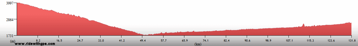
The desert potion of the route began just to the east of the town of Nasca, on the Pacific coastal plain. From there I turned north and made my way toward the capital, Lima. Interesting visits in that region included an airplane tour above the famous Nasca Lines, fascinating and mysterious geoglyphs of animals and other abstract designs, and a tour to the offshore Isla Ballestas, an island covered with birdlife and marine mammals. However, a bit of mechanical difficulties forced me to transfer over the last bit of that route, as I needed to be in Lima to depart for my sceduled side trip to the jungle.

The very arid western slopes of the Andes near Nasca

Hummingbird Geoglyph on the Nasca Plain

Inca Terns on Islas Ballestas

Pacific Coast at Lima

Lima Cathedral
The side trip I had planned had been one of my Tour goals since the very beginning, specifically, a visit to the isolated, and nearly car-free Amazon River city of Iquitos, and its surrounding humid tropical forest. Though my visit, unfortunately, did not include any cycling, I did not manage as much rest and relaxation as I might have liked. Iquitos had its heyday in an earlier rubber boom, but with little of that industry remaining and only river (sea going) or air access, I was rather surprised by the hectic and noisy atmosphere around town. My favorite area of the city was Puerto Belen, a frumpy, but friendly, traditional neighborhood of wooden homes built right at the edge of the mighty Amazon.
For my rainforest visit I arranged a stay at the excellent Yarapa River Lodge. That particular lodge is located, not surprisingly, on the Yarapa River, a tributary if the Amazon, a significant distance up river from Iquitos, and so provided a good location from which to see relatively undisturbed rainforest habitat. My bird list for the Tour grew considerably after than visit.

The Jungle city of Iquitos

Puerto Belen, a traditional neighborhood on the Amazon in Iquitos

The mighty Rio Amazon

Flooded Forest at Yarapa River Lodge

A Three-Toed Sloth

Scarlet Macaws

Giant Lilypads on the Rio Yarapa

Sunset at the Rio Yarapa
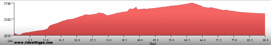
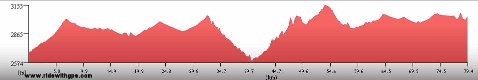
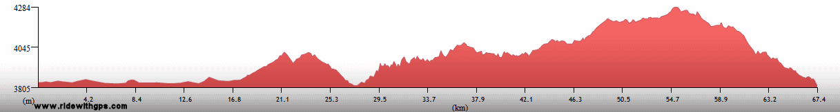
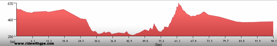
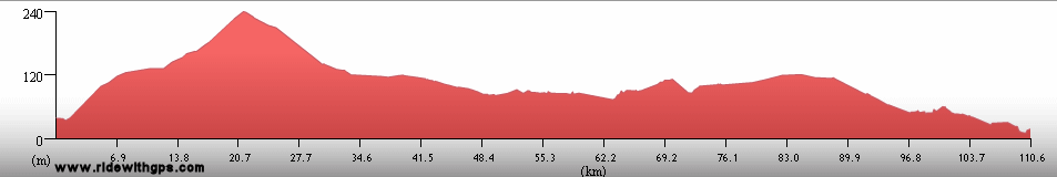
After I returned from the jungle, I was able, after an annoying wait, to get the bike up and running again and continued my northerly course along the coast. That section included one deviation from the coastal highway, a long, tiring climb into the mountains again to visit the ruins at Chavin de Huantar and Parque Nacional Huascaran in the snowy Cordillera Blanca range. Once back on the coast again, other interesting sites included the adobe pyramids at Huaca del Sol, Huaca del Luna, and Tacume, the excellent Museum of the Royal Tombs of Sipan in Lambayeque, as well as the historic district of Trujillo, and the nearby ruins of the adobe city of Chan Chan. On a more personal level there were also a few much appreciated opportunities to rest on some pleasant beaches, which was quite therapeutic after all the exertions of the previous couple of months.
Certainly the grandest post of all: ~HERE~

Callejon de Conchucos in the Cordillera Blanca

Fish Path wall decoration at Chan Chan adobe ruins

Huaca del Luna Fresco near Trujillo

Plaza de Armas in Trujillo
Previous | Next
Main Index | Pre-Tour Index
Post-Tour Index | Articles Index
Slideshows
Stage 4 Log
(continued)
For a description of terms and symbols look: ~HERE~
October 16, 02007
Encarnacion to Posadas, Argentina
Distance: 100 km
Terrain: Moderate to light rolling
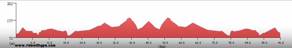
Max. Elevation: <300 m
Roads: RA 12 (Arg)
Max. Temp: 31 °C
Weather: Cloudy through midday, clearing to sunny in afternoon; moderate crosswinds
Accommodation:

Comment: Short day for border formalities and sightseeing; distance includes day ride to the north and back to visit Jesuit mission ruins at Santa Ana
October 17
Posadas to 15 km E. of Ita Itabe
Distance: 158 km
Terrain: Light rolling for a short section; flat
Max. Elevation: <300 m
Roads: RA 12
Max. Temp: 26 °C
Weather: Sunny, becoming mostly cloudy in afternoon; occasional light cross/tailwinds through morning
Accommodation:

Comment: A reasonable day; surprisingly less traffic than expected, though amount increased in afternoon
October 18
15 km E. of Ita Itabe to Corrientes
Distance: 176 km
Terrain: Flat
Max. Elevation: <300 m
Roads: RA 12
Max. Temp: 31 °C
Weather: Mostly sunny; occasional light to mild tail/crosswinds
Accommodation:
Comment: Mostly easy, but long and somewhat monotonous day; road narrow, but traffic only sporadically busy
October 19
Corrientes
Accommodation:
Comment: Rest/errands day in Corrientes
October 20
Corrientes
Accommodation:
Comment: Rest/repairs day in Corrientes; built new rear wheel
October 21
Corrientes
Accommodation:
Comment: Weather delay; probably could have ridden
October 22
Resistencia
Distance: 17 km
Accommodation:
Comment: Weather delay and errands day in Resistencia
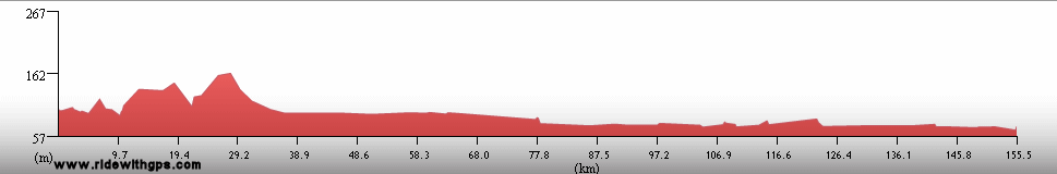
October 23
Resistencia to Presidente Roque Saenz Pena
Distance: 179 km
Terrain: Flat
Max. Elevation: <300 m
Roads: RA 16
Max. Temp: 27 °C
Weather: Cloudy, thunderstorm at sunrise and a little drizzle later; mild tailwinds
Accommodation:
Comment: Despite slow start, a generally easy day; road narrow but traffic not too bad
October 24
Presidente Roque Saenz Pena to Pampa del Invierno
Distance: 165 km
Terrain: Flat
Max. Elevation: <300 m
Roads: RA 16, (RP 94)
Max. Temp: 27 °C
Weather: Sunny; light tail/crosswinds
Accommodation:
Comment: Annoying day due to idiotic wrong turn that added 72 km to route
October 25
Pampa del Invierno
Accommodation:
Comment: Rest day in Pampa del Infierno; planned on breaking one day later, but due to mistake on previous day, would not have been in a good place; tried to catch up on writing backlog
October 26
Pampa del Invierno to Los Tigres
Distance: 158 km
Terrain: Flat
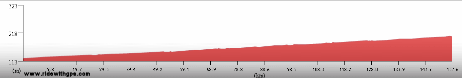
Max. Elevation: 306 m
Roads: RA 16 (30 km section bumpy or under repair)
Max. Temp: 38 °C
Weather: Sunny; moderate crosswinds, becoming occasional cross/tailwinds in afternoon
Accommodation:
Comment: A overall productive day, though tough in the morning due to wind, and in the afternoon due to heat
October 27
Los Tigres to Macapillo
Distance: 156 km
Terrain: Flat
Max. Elevation: 382 m
Roads: RA 16
Max. Temp: 34 °C
Weather: Sunny, with brief cloudy period at midday; occasional winds, various directions, becoming strong cross- to cross/tailwinds in afternoon
Accommodation:
Comment: A generally good day, though feeling a little tired
October 28
Macapillo to El Galpon
Distance: 138 km
Terrain: Flat, with very gradual elevation gain; light to moderate rolling
Max Elevation: 645 m
Roads: RA 16 (several bumpy sections)
Max. Temp: 36 °C
Weather: Morning clouds, then sunny; light to moderate tailwinds in afternoon
Accommodation:
Comment: Alternating conditions between easy and tiring; wanted to go somewhat farther, but tried to find lodging to escape heat, wasted time and distance doing so, and camped instead
October 29
El Galpon to Salta
Distance: 147 km
Terrain: Heavy rolling; flat with gradual decline; gradual 570-m climb; one small descent

Max. Elevation: 1,390 m
Roads: RA 16, RA 34, Salta Hwy
Max. Temp: 36 °C
Weather: Sunny, cloudy from mid-afternoon, with one heavy thunderstorm; light to mild tailwinds, becoming moderate in afternoon
Accommodation:
Comment: A more difficult day than expected; minimal services for first 2/3 of route
October 30-November 9
Salta
Accommodation:
Comment: Rest/errands/sightseeing days in Salta; visited archeological and ancient art museums; long delay due to mix-up with shipments of supplies
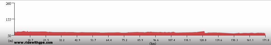
November 10
Salta to San Salvador de Jujuy
Distance: 98 km
Terrain: gradual 300-m climb/descent
Max. Elevation: 1,540 m
Roads: RA 9 (long section of single lane - nice!)
Max. Temp: 19 °C
Weather: Partly cloudy, becoming cloudy in afternoon; moderate tail/crosswinds
Accommodation:
Comment: Finally moving again; pleasant short day to Jujuy
November 11
San Salvador de Jujuy
Accommodation:
Comment: Weather delay in Jujuy; could have ridden, but wanted sunshine for next section
November 12
San Salvador de Jujuy to Tilcara
Distance: 84 km
Terrain: 1,020-m climb; one small descent; light rolling to flat, with gradual 450-m gain
Max. Elevation: 2,464 m
Roads: RA 9
Max. Temp: 26 °C
Weather: Sunny; light tailwinds, becoming strong to moderate in afternoon
Accommodation:
Comment: Good decision to wait previous day; beautiful half day through Quebrada de Humahuaca; start of climb to altiplano easier than expected, especially with tailwinds
November 13
Tilcara to Humahuaca
Distance: 46 km
Terrain: gradual 480-m climb
Max. Elevation: 2,940 m
Roads: RA 9
Max. Temp: 26 °C
Weather: Sunny; moderate tailwinds in afternoon
Accommodation:
Comment: Short, but slow half day for sightseeing and altitude acclimatization
November 14
Humahuaca to Abra Pampa
Distance: 90 km
Terrain: Fairly gradual 840-m climb, broken by section of rolling; light rolling to flat, with slight descent
Max. Elevation: 3,780 m
Roads: RA 9
Max. Temp: 22 °C
Weather: Sunny; a few storm clouds in afternoon; occasional moderate winds, various directions, becoming very strong headwinds in afternoon
Accommodation:
Comment: Slow start during climb; planned to go considerably farther, but decided against riding into bad wind; would not have gotten very far
November 15
Abra Pampa to Villazon, Bolivia
Distance: 76 km
Terrain: Flat; light to moderate rolling
Max. Elevation: 3,620 m
Roads: RA 9
Max. Temp: 23 °C
Weather: Partly sunny; light headwinds
Accommodation:
Comment: Another half day, stopped at border towns to make better schedule for next few days; wind and altitude made day feel longer
November 16
Villazon to Tupiza
Distance: 93 km
Terrain: Light to heavy rolling; 530-m descent; light to heavy rolling
Max Elevation: 3,530 m
Roads: Rd. 702 (Boliv.) (fair gravel - many corrugated sections)
Max. Temp: 31 °C
Weather: Cloudy, gradually becoming mostly sunny
Accommodation:
Comment: Slow day due to gravel road and terrain; some excellent scenery on second half of route
November 17
Tupiza to San Salvador de Cotagaita
Distance: 88 km
Terrain: 550-m climb; light to heavy rolling with gradual descent; 550-m descent (very slow)
Max. Elevation: 3,550 m
Roads: Rd. 702/14 (poor to fair gravel - many corrugated sections)
Max. Temp: 31 °C
Weather: Sunny, a few clouds in evening; occasional winds, various directions, stronger and towards headwinds in afternoon
Accommodation:

Comment: Expected to go considerably farther, but conditions slower than previous day; May be able to make up time on next day, as road is said to improve
November 18
San Salvador de Cotagaita to Vitichi
Distance: 82 km
Terrain: 330-m climb; hilly; 420-m descent; 550-m climb, broken by short descent; hilly
Max. Elevation: 3,115 m
Roads: Rd. 702 (first 67 km new pavement, then poor gravel)
Max. Temp: 33 °C
Weather: Sunny
Accommodation:
Comment: Another short day; terrain much harder than expected, and gravel road very slow. Delay necessary anyway due to another shipment problem
November 19
Vitichi to Potosi
Distance: 93 km
Terrain: Moderate rolling, with gradual 350-m gain; gradual 300-m climb; 620-m climb; light rolling; one small climb (Cerro Rico Pass); 400-m descent
Max Elevation: 4,410 m
Roads: Rd. 702 (first 40 km fair to poor gravel), Hwy 1
Max. Temp: 26 °C
Weather: Partly cloudy, becoming partly sunny by afternoon, thunderstorm crossing route in late afternoon, but only a few raindrops; occasional strong winds from various directions when storm in area
Accommodation:
Comment: A very slow day due to gravel road, terrain, and altitude; would not have reached city on previous day
November 20-22
Potosi
Accommodation:
Comment: Rest/sightseeing day in Potosi; visited imperial mint museum, Cerro Rico mines; extra day delay due to another supplies shipment
November 23
Potosi to Sucre
Distance: 158 km
Terrain: Gradual 300-m descent; alternating sections of hilly and light rolling; 700-m descent; hilly; rolling 550-m climb; rolling 300-m descent
Max Elevation: 4,060 m
Roads: Hwy 5
Max. Temp: 30 C
Weather: Sunny; becoming partly cloudy with storms in area in afternoon; 2 moderate thundershowers; occasional moderate winds, various directions in afternoon
Accommodation:
Comment: Mostly a very nice day; some great scenery; less pleasant when showers arrived, rode through first, waited out second; last 7 km delayed by big political protests with burning tires and tear gas
November 24
Sucre
Accommodation:
Comment: Sightseeing/rest day in Sucre; most of city closed due to political protests
November 25
Sucre to Betanzos
Distance: 113 km
Terrain: Rolling 300-m climb; rolling 550-m descent; hilly; 700-m climb; hilly
Max. Elevation: 3,320 m
Roads: Hwy 5
Max. Temp: 32 °C
Weather: Mostly sunny, becoming partly cloudy in afternoon; occasional light tail/crosswinds, becoming constant in late afternoon
Accommodation:
Comment: Reverse of previous day, back to Potosi; a tiring, short day, but still a beautiful ride
November 26
Betanzos to Potosi
Distance: 60 km
Terrain: Hilly, with elevation gain; gradual 300-m climb
Max. Elevation: 4,060 m
Roads: Hwy 5
Max. Temp: 28 °C
Weather: Partly sunny, one localized thundercloud with minimal precipitation in afternoon; light tailwinds
Accommodation:
Comment: Short half day back to Potosi after visiting hard-to-find petroglyph site near Betanzos; extra 15 km for that visit; received package of supplies with fresh clothes
November 27
Potosi to 17 km S. of Ventilla
Distance: 90 km
Terrain: 450-m descent; moderate rolling to hilly; 300-m climb/descent; 765-m climb (unnamed pass); one small descent; light rolling; hilly
Max Elevation: 4,325 m
Roads: Hwy 1
Max. Temp: 26 C
Weather: Mostly sunny through morning, mostly cloudy in afternoon, with localized storm clouds but no significant rain; moderate winds when clouds nearby, various directions
Accommodation:
Comment: A very late start, then a unexpectedly tough day with much more climbing than expected; planned to go considerably farther; some great scenery
November 28
17 km S. of Ventilla to Poopo
Distance: 169 km
Terrain: Hilly; small descent; hilly; light rolling; flat
Max. Elevation: 4,320 m
Roads: Hwy 1
Max. Temp: 21 °C
Weather: Mostly sunny during morning, mostly cloudy with localized storm clouds at midday, partly cloudy in afternoon; occasional moderate winds at midday, various directions, strong to very strong crosswinds to head/crosswinds in afternoon
Accommodation:
Comment: A better day; still difficult terrain for first third of route, easier after that; winds tough in afternoon
November 29
Poopo to Oruro
Distance: 66 km
Terrain: Flat, with just a little light rolling
Max. Elevation: 3,820 m
Roads: Hwy 1
Max. Temp: 23 °C
Weather: Partly sunny, with scattered storm clouds; period of very strong crosswinds during morning, changing to light head/crosswinds
Accommodation:
Comment: Awoke not feeling very well, planned on a full day, but very tired by mid morning so stopped in Oruro
November 30
Oruro
Accommodation:
Comment: Felt better, and could have ridden, but decided to take an extra recovery day to be sure
December 1
Oruro to Pataca Maya
Distance: 130 km
Terrain: Flat; two small, gradual climbs/descents; light rolling
Max. Elevation: 3,970 m
Roads: Hwy 1 (F-01)
Max. Temp: 18 °C
Weather: Mostly cloudy, partial clearing at midday, then fully cloudy in afternoon; storms in area, but no rain on route; occasional mild to strong winds, usually cross or cross/tailwinds
Accommodation:
Comment: A rather dreary, chilly day; not feeling quite 100%; could have gone farther, but not really necessary
December 2
Pataca Maya to La Paz
Distance: 107 km
Terrain: Light to heavy rolling; 400-m descent
Max. Elevation: 3,995 m
Roads: Hwy 1 (F-01), Local Rds.
Max. Temp: 11 °C
Weather: Cloudy, with a few periods of light rain (1 with sleet)
Accommodation:
Comment: A cold, short day to a break in La Paz
December 3-4
La Paz
Accommodation:
Comment: Rest/sightseeing/errands days in La Paz; visited Witch's Market and Ethnographic Museums
December 5
La Paz to Tiwanaku
Distance: 77 km
Terrain: 400-m climb; flat to light rolling; light rolling; one small climb/descent; light rolling
Max. Elevation: 4,029 m
Roads: Local Rds., Hwy 1
Max. Temp: 25 °C
Weather: Mostly sunny, becoming mostly cloudy in afternoon; occasional light tailwinds
Accommodation:
Comment: After slow climb leaving city, a mostly easy half day to Tiwanaku; visited archeological site of ancient Tiwanaku capital
December 6
Tiwanaku to Huatajata
Distance: 106 km
Terrain: Light rolling; one small climb/descent; light rolling
Max. Elevation: 4,029 m
Roads: Hwy 1, Laja-Patamanta Cut-Off (poor to fair dirt/gravel), Hwy 1N
Max. Temp: 26 °C
Weather: Partly sunny, becoming mostly to partly cloudy; widely scattered showers, but none near route; occasional mild winds, various directions, becoming light to moderate headwind in late afternoon
Accommodation:
Comment: Late start for another brief visit to Tiwanaku; short-cut eliminated over 60-km of distance, including a return to El Alto; reached Lake Titicaca
December 7
Huatajata to Copacabana
Distance: 68 km
Terrain: Moderate rolling; one small climb/descent; 450-m climb/descent (Copacabana Pass)
Max. Elevation: 4,300 m
Roads: Hwy 1N, Straight of Tiquina Ferry, Hwy 1N
Max. Temp: 25 °C
Weather: Mostly sunny; occasional light winds, various directions
Accommodation:
Comment: A spectacular half day to break in Copacabana; summit of climb 200 m higher than map indicated
December 8
Copacabana
Accommodation:
Comment: Beautiful sightseeing day on Lake Titicaca; visited Isla del Sol and Isla del Luna
December 9
Copacabana to Puno, Peru
Distance: 146 km
Terrain: Moderate rolling; flat to light rolling; one small climb/descent; flat to light rolling
Max. Elevation: 3,880 m
Roads: Hwy 1N, Hwy 3 (Peru) (long sections bumpy)
Max. Temp: 21 °C
Weather: Party sunny; thunderstorm in early afternoon; light crosswinds, becoming moderate to light tailwinds after storm
Accommodation:
Comment: A mixed day; felt a little sluggish early and slowed by road condition; reached destination without too much trouble
December 10
Puno
Accommodation:
Comment: Sightseeing day on Lake Titicaca; visited Uros floating islands and Isla Taquile
December 11
Puno to Pucara
Distance: 135 km
Terrain: One small climb/descent; flat to light rolling
Max. Elevation: 3990 m
Roads: Hwy 3 (somewhat bumpy)
Max. Temp: 21 °C
Weather: Partly sunny to partly cloudy; light cross/tailwinds
Accommodation:
Comment: A generally easy day; distance includes 28 km side trip for sightseeing at Sillustani pre-Inca ruins; also visited Inca ruins at Pucara
December 12
Pucara to Sicuani
Distance: 149 km
Terrain: Light rolling to flat; 340-m climb (La Raya Pass); 670-m descent, gradual at end; flat to light rolling
Max. Elevation: 4,338 m
Roads: Hwy 3
Max. Temp: 20 °C
Weather: Partly sunny, becoming mostly cloudy at midday; showers in area but no significant rain on route; moderate tailwinds
Accommodation:
Comment: A fairly easy day; road condition better
December 13
Sicuani to Cusco
Distance: 145 km
Terrain: Light to moderate rolling, with gradual descent, then gradual climb
Max Elevation: 3,614 m
Roads: Hwy 3S
Max. Temp: 20 C
Weather: Cloudy, with periods of partial clearing around midday; light rain during afternoon with one heavy downpour
Accommodation:
Comment: A mixed day, enjoyable until rain started; visited Viracocha's Temple in Raqui; entrance to city extremely hectic, muddy, and unpleasant
December 14-16
Cusco
Accommodation:
Comment: Rest/errands days in Cusco; made plans for upcoming visits; visited city museums and Sacsayhuaman Fortress ruins
December 17
Cusco to Ollantaytambo
Distance: 95 km
Terrain: 370-m climb; 720-m descent; flat to light rolling
Max. Elevation: 3,770 m
Roads: Local Rds., Cusco-Pisac Rd, Sacred Valley Hwy.
Max. Temp: 23 °C
Weather: Cloudy, with occasional periods of sun, and a little light rain/drizzle (mostly when off the bike); mild tailwinds, changing to light headwinds over last 15 km
Accommodation:
Comment: Short day with several sightseeing stops; spectacular ride through the Sacred Valley; visited Pucapucara, Tambomachay, and Pisaq sanctuary ruins
December 18
Machu Picchu Pueblo
Accommodation:
Comment: Morning rail transfer to Machu Picchu; sightseeing at Machu Picchu Sanctuary
December 19
Machu Picchu Pueblo
Distance: 13 km
Accommodation:
Comment: Rest day in Machu Picchu Pueblo; had planned on visiting ruins a 2nd time, but saw everything on previous day when weather was better; went for short flora and fauna viewing ride between rain showers
December 20
Ollantaytambo to Zurite
Distance: 66 km
Terrain: Flat to light rolling; 655-m climb; light rolling to flat; one small descent; flat to light rolling
Max. Elevation: 3,585 m
Roads: Sacred Valley Hwy., Urubamba-Chinchero Rd., Izcucacha Cut-off (fair to good dirt/gravel), Hwy 3S
Max. Temp: 23 °C
Weather: Partly sunny; with a few widely scattered light showers, but none on route; moderate tailwinds through morning
Accommodation:
Comment: Short half day after rail transfer to Ollantaytambo; visited Ollantaytambo Inca ruins
December 21
Zurite to Sawite Pass
Distance: 120 km
Terrain: 385-m climb; 1,735-m descent; 1,840-m climb (incomplete)
Max Elevation: 3,820 m
Roads: Hwy 3S
Max. Temp: 32 C
Weather: Mostly sunny, few widely scattered showers in area, but no rain on route; occasional light winds, various directions
Accommodation:
Comment: A beautiful, but difficult, day; terrain much more intense than expected; planned on descending from summit, but had to stop due to darkness
December 22
Sawite Pass to 17 km SW. of Santa Rosa
Distance: 133 km
Terrain: One small climb (final 150 m of climb from previous evening); 2,080-m descent (broken by town of Abancay); light to moderate rolling, with very gradual 700-m gain
Max. Elevation: 3,980 m
Roads: Hwy 3S, Hwy 26
Max. Temp: 35 °C
Weather: Some early morning clouds, then mostly sunny; huge thundershower just before sunset; moderate to strong tailwinds in afternoon
Accommodation:
Comment: An excellent day; splendid ride up Pacacocha canyon; wanted to go just slightly farther, but stopped in tiny village just before storm hit
December 23
17 km SW. of Santa Rosa to Iscahuaca
Distance: 90 km
Terrain: Light to moderate rolling, with very gradual 900-m gain; 765-m climb; light to moderate rolling
Max. Elevation: 4,265 m
Roads: Hwy 26
Max. Temp: 28 °C
Weather: Party sunny, becoming cloudy in afternoon; strong winds, a little light rain and cold at top of climb
Accommodation:
Comment: A generally good, but short day; stopped a little early to avoid wet and cold
December 24
Iscahuaca to Puquio
Distance: 138 km
Terrain: 330-m climb/descent; 300-m climb; hilly to moderate rolling; one small descent/climb; 1,000-m descent
Max. Elevation: 4,550 m
Roads: Hwy 26
Max. Temp: 17 °C
Weather: Mostly sunny; large thunderstorm close to route in afternoon, but was able to ride past; moderate head/crosswinds when storm clouds near
Accommodation:
Comment: A harder day than expected due to terrain, until final descent which was longer than expected
December 25
Puquio to Nazca
Distance: 163 km
Terrain: 300-m climb; 410-m descent; 1,000-m climb; light rolling, with gradual 200-m loss; 3,400-m descent, gradual with some rolling at top, then faster; flat
Max. Elevation: 4225 m
Roads: Hwy 26 (mostly bumpy)
Max. Temp: 26 °C
Weather: Mostly sunny, partly cloudy at midday near top of climb, with brief, light shower including some hail; partly cloudy, with haze during descent; light winds, various directions
Accommodation:
Comment: A long day; disappointed by poor road which slowed big descent. Feliz Navidad!
December 26
Nazca
Accommodation:
Comment: Sightseeing/rest day in Nazca; took flight to view Nazca geoglyphs; not feeling 100%
December 27
Nazca to Ica
Distance: 100 km
Terrain: Flight to light rolling; moderate rolling; two small climbs/descents; flat
Max Elevation: 670 m
Roads: Hwy 1
Max. Temp: 36 C
Weather: Hazy clouds; light tailwinds through morning, becoming strong cross/headwinds in afternoon
Accommodation:
Comment: A reasonable start, then problems when hub bearing failed; had to walk for a few hours, before getting a lift to town
December 28
Pisco
Accommodation:
Comment: Unable to make repairs with parts on hand; bus transfer to Pisco
December 29
Pisco
Accommodation:
Comment: Sightseeing/rest day in Pisco; took boat tour to Islas Ballestas, many sea birds and sea lions; town in bad shape after earthquake 4 months earlier
December 30
Lima
Accommodation:
Comment: Bus transfer to Lima
December 31-January 1, 02008
Lima
Accommodation:
Comment: Happy New Year in Lima; waiting for flight to Iquitos to visit Amazon basin
January 2-5
Yarapa River Lodge
Accommodation:
Comment: Early morning air transfer to Iquitos, then road/river boat transfer to Yarapa Lodge; delayed when boat broke down during trip; rainforest visits
January 6-7
Iquitos
Accommodation:
Comment: Errands/sightseeing days in Iquitos; walking/canoe tour of Puerto Belen traditional river neighborhood; visited Alpahuayo Mishana Forest Reserve, Pilpintuwasi Butterfly Farm and Animal Rescue Center
January 8
Lima
Accommodation:
Comment: Evening air transfer back to Lima
January 9
Lima
Accommodation:
Comment: Errands day in Lima
January 10-17
Lima
Accommodation:
Comment: Delay due to shipment of replacement parts; visited historic city center and museums; finally repaired hub
January 18
Lima to Chancay
Distance: 105 km
Terrain: Flat to light rolling; one small climb/descent; 370-m climb; one small descent/climb; 300-m descent; flat to light rolling
Max. Elevation: 440 m
Roads: Local Rds., Hwy 18, Hwy 1
Max. Temp: 29 °C
Weather: Hazy; occasional light to mild cross/tail to cross/headwinds
Accommodation:
Comment: On the move again finally; planned on going considerably farther, but felt sluggish after long layoff; first 35 km through urban/industrial areas
January 19
Chancay to Barranca
Distance: 123 km
Terrain: Flat to light rolling; hilly; moderate rolling; flat to light rolling

Max. Elevation: <300 m
Roads: Hwy 1
Max. Temp: 27 °C
Weather: Fog through morning, then sunny; mild to light tail/crosswinds through morning, becoming light tailwinds in afternoon
Accommodation:
Comment: Another day shorter than planned; still a little tired and decided to stop at beach town in early evening before returning to mountains; May need to adjust schedule
January 20
Barranca to 23 km N. of Chasquitambo
Distance: 87 km
Terrain: Flat to light rolling; 1,565-m climb (significantly incomplete)
Max Elevation: 1,615 m
Roads: Hwy 1, Hwy 2/14
Max. Temp: 34 °C
Weather: Cloudy/foggy, with period of sun around midday
Accommodation:
Comment: A disappointingly tough day, mostly due to heat at start of big climb, cooler in afternoon; wanted to get somewhat higher
January 21
23 km N. of Chasquitambo to Conococha
Distance: 54 km
Terrain: 2,485-m climb
Max. Elevation: 4,100 m
Roads: Hwy 2/14
Max. Temp: 25 °C
Weather: Mostly cloudy/foggy
Accommodation:
Comment: Another difficult day; planned on descending and riding further, but decided to stay at summit of climb
January 22
Conococha to Chavin de Huantar
Distance: 115 km
Terrain: Moderate rolling, with gradual 500-m descent; 925-m climb; 1210-m descent

Max. Elevation: 4,485 m
Roads: Hwy 2/14, Callejon de Conchucos Rd. (many places with several potholes, on descent several sections of gravel , and areas with recent rockslides)
Max. Temp: 21 °C
Weather: Partly to mostly cloudy; short periods of light rain/drizzle in afternoon
Accommodation:
Comment: A mixed day; still tired at end of climb, and descent not especially fast due to road condition; arrived on time for rest break at Chavin
January 23
Chavin de Huantar
Accommodation:
Comment: Sightseeing/rest day in Chavin; visited ancient temple complex ruins
January 24
Chavin de Huantar to Huaraz
Distance: 114 km
Terrain: 1,240-m climb; 925-m descent; moderate to light rolling, with gradual 500-m descent
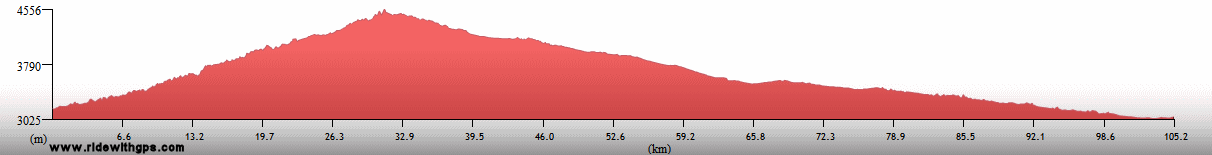
Max. Elevation: 4,485 m
Roads: Callejon de Conchucos Rd. (same conditions as previous), Hwy 3N
Max. Temp: 23 °C
Weather: Cloudy at morning, clearing to partly sunny early, two showers during descent, with sleet/hail, showers in afternoon; occasional moderate winds from various directions in afternoon
Accommodation:
Comment: A more pleasant day than expected, until weather turned poor
January 25
Huaraz
Accommodation:
Comment: Rest day in Huaraz
January 26
Huaraz to Colcabamba
Distance: 80 km
Terrain: 1,125-m climb (rough); 1,900-m descent (incomplete and very rough)
Max Elevation: 4,250 m
Roads: Hwy 14a (first 3 km very muddy dirt/gravel; 20-km section under construction, various conditions; remainder, including all descent, poor to fair dirt/gravel with many wet sections)
Max. Temp: 21 °C
Weather: Partly sunny, mostly cloudy, with light drizzle at summit, foggy, often thick, in afternoon; strong winds at summit, various directions
Accommodation:
Comment: An even more difficult day than expected, mostly due to poor road condition; expected to get considerably farther
January 27
Colcabamba to Chimbote
Distance: 135 km
Terrain: 2,100-m descent (first 11 km rough), broken by 2 small climbs; flat; short hilly section; flat with a couple small hills
Max. Elevation: 2,300
Roads: Hwy 14a (11 km poor to fair dirt/gravel, remainder paved), Hwy 1
Max. Temp: 34 °C
Weather: Cloudy, partial clearing in afternoon; moderate to light crosswinds in afternoon
Accommodation:
Comment: After rough start, a reasonable day
January 28
Chimbote to Trujillo
Distance: 145 km
Terrain: Flat, with a few small hills; 365-m climb; one small descent; hilly; one small descent
Max. Elevation: 370 m
Roads: Hwy 1
Max. Temp: 28 °C
Weather: Mostly cloudy; occasional light to moderate crosswinds in afternoon
Accommodation:
Comment: A reasonable day, but felt a little tired; includes extra 10 km to visit Huacas del Sol y Luna pyramid ruins
January 29
Trujillo
Accommodation:
Comment: Sightseeing/rest day in Trujillo; visited Chan Chan archeological complex
January 30
Trujillo to Pacasmayo
Distance: 115 km
Terrain: One very gradual small climb/descent; flat to light rolling
Max Elevation: <300 m
Roads: Hwy 1
Max. Temp: 35 C
Weather: Sunny; moderate cross/tailwinds
Accommodation:
Comment: A generally easy day, but stopped considerably earlier than planned to stay at only ocean access for this section
January 31
Pacasmayo to Lambayeque
Distance: 125 km
Terrain: Flat to light rolling
Max. Elevation: <300 m
Roads: Hwy 1
Max. Temp: 37 °C
Weather: Sunny; mild cross/headwinds during morning, becoming moderate crosswinds in afternoon
Accommodation:
Comment: Another fairly short day; got somewhat lost going through Chiclayo; stopped for brief sightseeing; visited Museo de Tumbas Real de Sipan
February 1
Lambayeque to Querpor
Distance: 143 km
Terrain: Flat; flat with small, very gradual gain; one small climb/descent; flat, with small, very gradual, descent

Max. Elevation: 370 m
Roads: Hwy 1, Hwy 1B
Max. Temp: 34 °C
Weather: Sunny; light cross to cross/tailwinds, becoming moderate crosswinds in afternoon
Accommodation:
Comment: A reasonably good day, though midday heat felt worse than reality and very tiring; visited Pyramids of Tucume archeological site
February 2
Querpor to Sullana
Distance: 171 km
Terrain: Light rolling to flat; one small climb/descent; moderate to light rolling

Max Elevation: 365 m
Roads: Hwy 1B, Hwy 1 (poor shoulder)
Max. Temp: 37 °C
Weather: Mostly to partly sunny; occasional mild to moderate winds, various directions, becoming moderate tailwind in late afternoon
Accommodation:
Comment: A generally good day, but fairly tiring; actual distance slightly longer than signage indicated
February 3
Sullana to Mancora
Distance: 154 km
Terrain: All types between flat and heavy rolling, plus a few small climbs/descents
Max Elevation: 310 m
Roads: Hwy 1A
Max. Temp: 35 C
Weather: Mostly sunny; mild to moderate tail/crosswinds
Accommodation:
Comment: A pleasant start, but later tedious and tiring
February 4
Mancora
Accommodation:
Comment: Rest day in Mancora
February 5
Mancora to Huaquillas, Ecuador
Distance: 143 km
Terrain: Light rolling to flat; flat
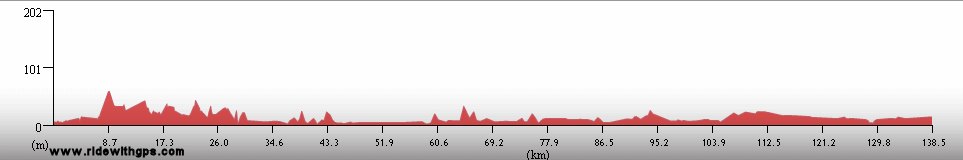
Max. Elevation: <300 m
Roads: Hwy 1A
Max. Temp: 33 °C
Weather: Mostly cloudy in morning and afternoon, otherwise partly sunny; moderate headwinds at midday, becoming light cross/tailwinds in afternoon
Accommodation:
Comment: A generally easy day, except for windy section; very slow immigration procedures leaving Peru; 8 km extra distance to get to Ecuadorian immigration post and then back to town
Continued on Next Page
Index | Next Page
Pre-Tour Stage 1 Stage 2 Stage 3 Stage 4 Stage 5 |