
Stage 1: Into the Tropics
Warm weather at last, and a real change of scene
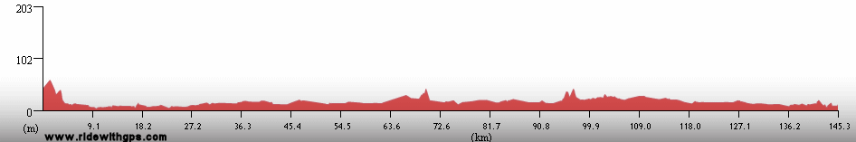
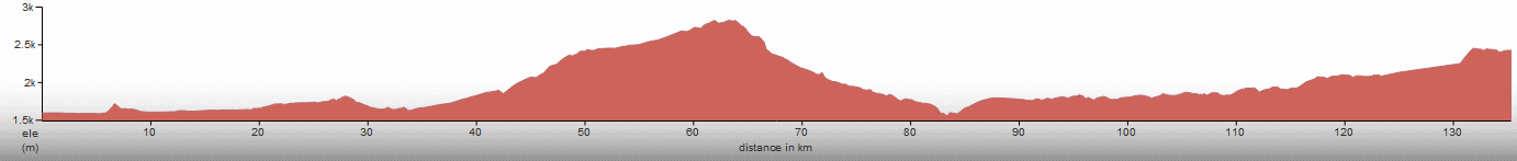
Stage 1 Actual Route
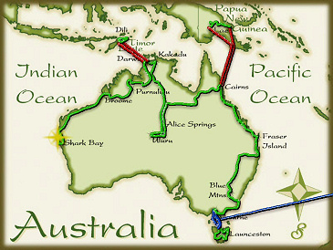
On this, and all other route maps, the blue lines represent travel by ship, red by airplane (Booo!), and green by bicycle.
Coastal Queensland: Easy Riding & Sunshine
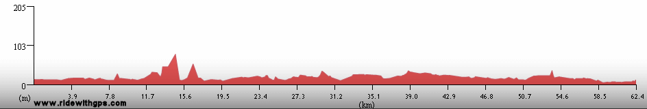
After a few days of really, really torrential rain when I was in the vicinity of Brisbane, which was complicated by the sprawling congestion around that city (I made a good choice to pass through town on the local commuter rail,) the conditions on the east coast of Queensland finally eased up and I had a nice time on the ride up to Cairns. The sun was out every day, daytime high temperatures were consistently in the mid 20's, the wind was usually in my favor, or at least not a tremendous problem, and the terrain was flat, though with many hills nearby to add some visual appeal. I took the opportunity to bring up my pace a little in order to make up for some of the delays I had earlier. However, there was still time for some nice breaks. The coast of Queensland is lined, or at least was--now only remnant fragments remain--of a distinctive tropical rainforest. Areas that were deforested are now mostly used to grow sugar cane. I have not seen as much cane since my Cuba tour in '02, and it made me feel like I was really out of the cold and wet for good. Stops along the way were at Fraser Island, a truly interesting place and one of the largest sand islands in the world, but which is not really rideable by bike (I wish I had more than a day and a half to spend there), Rockhampton, a pleasant town with a lot of colonial-era buildings, and at Lucinda beach, a tiny coastal town. The latter was a little frustrating since I was not able to get myself just across the narrow sound adjacent to the beach to Hinchbrook Island a pristine island covered with rainforest and part of the Wet Tropics of Queensland WHS. No one would rent me a boat because I did not have a dingy license, and there were no kayaks or canoes available because the sound was crocodile territory. I had to wait until later in Cairns to see the Wet Tropics area.
Cairns was a pretty nice place to take a day off to get ready for the next section, though it was a little on the expensive side. It is now a town completely dedicated to tourism, and its main focus seems to be dragooning the parade of visitors onto various bus tours and other guided "Adventures." Not quite my style, but then I was only interested in resting there in any case.
Slightly more detail in a Queensland post: ~HERE~
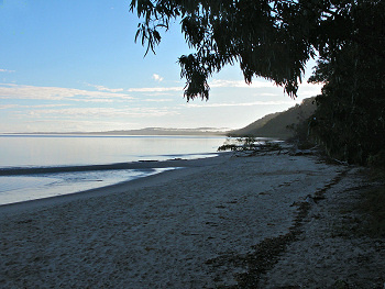
The beach at Fraser Island
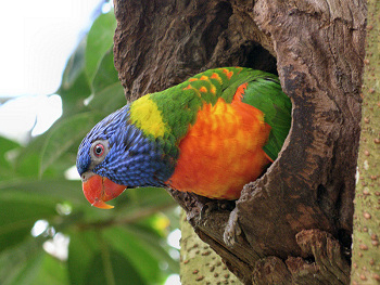
A rainbow lorikeet
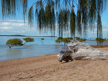
Casuarina & mangroves at Claireview beach
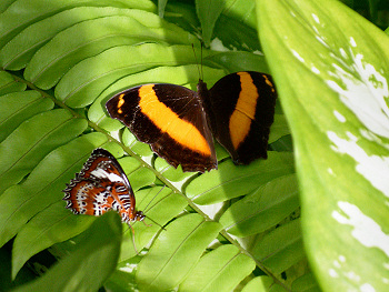
The Kuranda Butterfly Aviary
Papua New Guinea: Another World
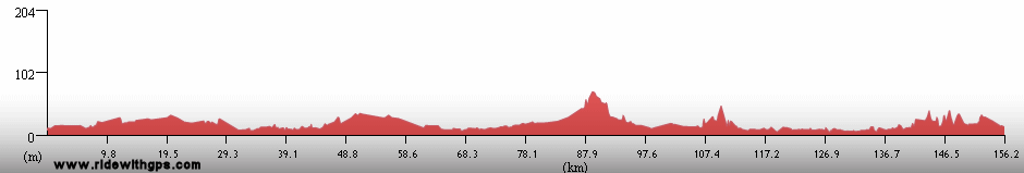
The major event of this section was a fabulous side trip to Papua New Guinea, where I toured up into the Central Highlands of that large island country. I could write pages and pages about that experince, but there just isn't time for that. There were a few things that really stood out, however. The Island of New Guinea is a part of Gondwanaland that has at times been fairly isolated and at other times no so much. It is reasonably close to the islands of the Indonesian archipelago, but far enough that only plants and birds from Asia have had an easy time in colonizing the island. However during glacial periods, when sea level is much lower, the island has been connected to Australia, and so shares many floral and faunal families with the continent. When I reached the high country in the center of the island, generally above 2,000 meters, I was surprised that the feel of the countryside was not what I had been expecting at all. At 4 degrees south of the equator, I expected thick jungle, filled with palms and other rainforest trees. Instead the countryside is rather open and green with many groves of species like casuarina, from Australia, and mimosa, from Asia. This may, in part, be due to the fact that the island has been inhabited for tens of thousands of years, by descendants of those people who first migrated from Africa to Australia, and who have been living and practicing gardening-type agriculture in the highlands valleys for all that time.
And speaking of the people, that was the most interesting aspect of my tour there. The highlands are relatively densely populated and everywhere I went I drew a large crowd of curious locals who were wondering what I was doing. New Guinea has an undeserved reputation as a violent, crime-ridden place, but I found that to not be the case at all. Everybody there still feels that it is, however, and it was a little tough for me to rest peacefully, or go anywhere on my own. Everyone I met tried to be my guide or escort, as they were concerned about my well-being. I had a little difficulty conveying the message that I am a grown man, capable of taking care of myself. All in all, though, that was not such a bad problem to have. I also became a bit of a local celebrity while I was there. Most local people travel the country on crowded mini-busses, and often as they would pass me by someone would ask "Waryugo?" (that's Pidgin English, the local lingua franca, for "Excuse me Sir, what is your destination?"), and the related, "Waryucomfrom" I would answer that I started in Lae, and was riding to Tari, which always prompted a reply of "Sheeeet". Inevitably, a few days later somene else would come up to me and say "You come from Lae? My Brother saw you two days ago! Sheeeeet!". I enjoyed that for the most part, but it did get a little tiring after a while. Does one's 15 minutes of fame still count if it occurs in PNG?
Nevertheless, I really do prefer traveling in the sort of place where people are open, easy to approach (as they are usually found just walking along the roadside,) and genuinely glad to see me. That was certainly the case in PNG. The only disappointments of my visit were that the cloudy skies often muted some of the best vistas, and that the island's famous birds and animals were not visible outside of the deep, deep, jungle, a place that I did not have the opportunity to visit.
The first post from a really unique place is: ~HERE~
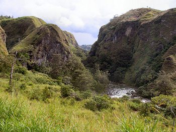
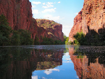
The Lair River Gorge
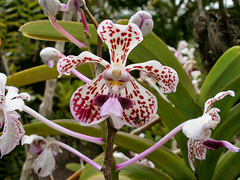
An elegant orchid in bloom
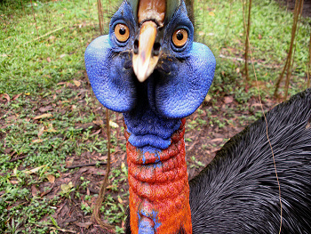
A Northern Cassowary
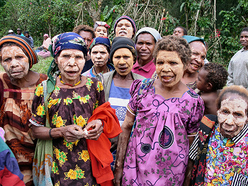
Women of Kapo Village
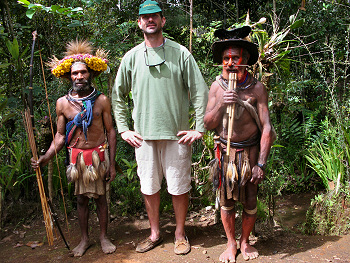
I meet some Huli men
Outback Queensland: Yet Another World
Returning back to the Australian mainland, I continued, with yet another big change of scene, by turning west and heading into the Outback, After the early wet, cold and hilly weeks of the Stage, I was definitely ready for some flat riding and the warm dry weather that I expected in that part of the continent. First, though, while still in Cairns, I took the opportunity to visit the famous Great Barrier Reef, which was a fascinating experience. Back on the bike again, it did not take long for the environment to change as I rode west. Savanna replaced rainforests, and giant termite mounds, for the most part, replaced settlements of people. From that point on, the distances between towns drastically increased, and there were few towns of any significant size. That was fine with me, for a while, at least, as after the crowds of PNG some solitude was somewhat welcome.
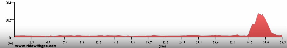
The main destinations along that section were Lawn Hill Gorge and the Riversleigh Fossil Site at Boodmajulla National Park. To get there required a ride over the longest stretch, around 350 km, of bumpy dirt road of the entire Stage. It was a tough section to be sure, but the park was nice and I was glad I made it. The rest of the way through to the border of Northern Territory, was somewhat uneventful, but I enjoyed the peace and quiet, especially at nighttime, when the open savanna provided some of the most ideal spots for camping I've seen in a long while.
Read my first post from the Outback: ~HERE~
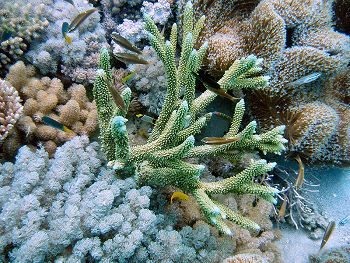
The Great Barrier Reef
Lawn Hill Gorge
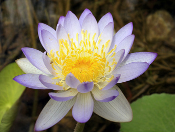
An Beautiful water lily in the Gregory River
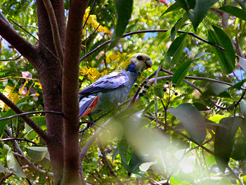
A pale-headed rosella
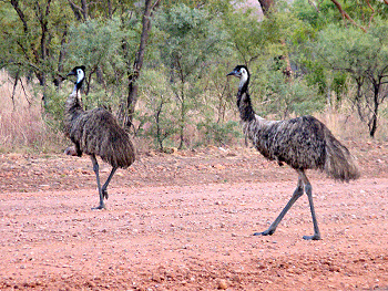
A pair of Emus walk across the road
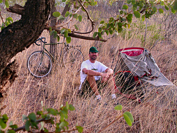
Camping in the Outback
Previous | Next
Main Index | Pre-Tour Index
Post-Tour Index | Articles Index
Slideshows
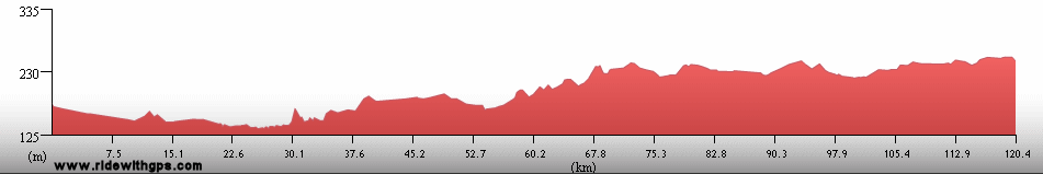
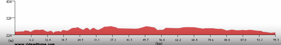
Stage 1 Log
(continued)
For a description of terms and symbols look: ~HERE~
June 28, 02005
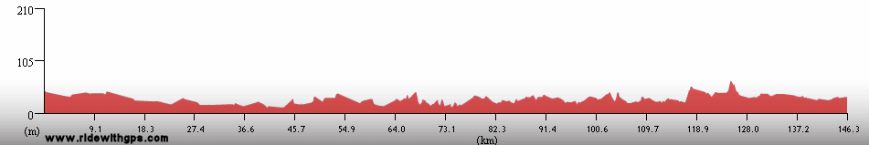
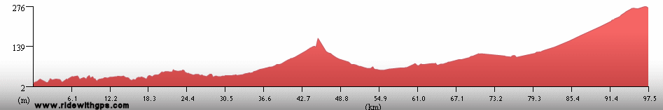
Lismore to Palm Beach, Queensland
Distance: 129 km
Terrain: Moderate to heavy rolling
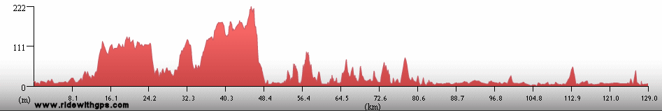
Max. Elevation: <300 m
Roads: Bangalow Rd., Friday Hut Rd., Coolmah Scenic Dr., Hwy 1, Tourist Dr. 36, Hwy 1, Local streets
Max. Temp: 19 °C
Weather: Rain, with several heavy showers
Accommodation:

Comment: Some nice, quiet backroads, and some horribly unpleasant highways
June 29
Palm Beach/Caboolture to Montville
Distance: 70 km
Terrain: Flat; light to moderate rolling; hilly, 450-m climb
Max. Elevation: 495 m
Roads: Hwy 60, Tourist Dr. 24, Tourist Dr. 23
Max. Temp: 22 °C
Weather: Rain, with heavy showers
Accommodation:
Comment: Took commuter train through Bisbane sprawl to Caboolture; stayed in Montville due to torrential rain
June 30
Montville to Tiaro
Distance: 158 km
Terrain: Hilly, light to moderate rolling
Max. Elevation: 443 m
Roads: Tourist Dr. 23, Obi Obi Rd., Hwy 51, Hwy 1
Max. Temp: 27 °C
Weather: Damp morning, clearing by midday; occasional headwinds
Accommodation:

Comment: Finally saw the Sun again
July 1
Tiaro to Fraser Island
Distance: 70 km
Terrain: Light to moderate rolling
Max. Elevation: <300 m
Roads: Hwy A1, Hwy 57
Max. Temp: 27 °C
Weather: Morning clouds; clearing by evening w/ 1 or two light showers
Accommodation:
Comment: Half day to get to Fraser Island
July 2
Fraser Island
Max. Temp: 25 °C
Weather: Morning clouds, then sunny
Accommodation:
Comment: Rest/sightseeing day on Fraser Island
July 3
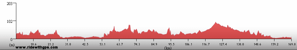
Fraser Island to Cordaltra
Distance: 123 km
Terrain: Light to moderate rolling
Max. Elevation: <300 m
Roads: Hwy 57, Torbanlea Rd, Hwy A1, Hwy 3
Max. Temp: 22 °C
Weather: Sunny, overcast by late afternoon; occasional tailwinds
Accommodation:
Comment: Half day for transfer back from Fraser Is., easy riding afterwards
July 4
Cordaltra to Bororen
Distance: 172 km
Terrain: Light to moderate rolling
Max. Elevation: <300 m
Roads: Hwy 3, Lowmead-Bundaburg Rd., Tablelands Rd., Fingerbend Rd., Hwy A1
Max. Temp: 24 °C
Weather: Sunny; beautiful tailwinds
Accommodation:
Comment: A pleasant, fairly easy day
July 5
Bororen to 12 km S of Rockhampton
Distance: 161 km
Terrain: Light to moderate rolling
Max. Elevation: <300 m
Roads: Hwy A1
Max. Temp: 25 °C
Weather: Sunny; tailwinds
Accommodation:
Comment: Another nice day; many trucks
July 6
Rockhampton
Distance: 18 km
Max. Temp: 26 °C
Weather: Sunny
Accommodation:
Comment: Rest/sightseeing day in Rockhampton; visited Dreamtime Center and Botanical Garderns
July 7
Rockhampton to Tooloomban
Distance: 157 km
Terrain: Light rolling to flat
Max. Elevation: <300 m
Roads: Hwy A1
Max. Temp: 27 °C
Weather: Mostly sunny; more great tailwinds
Accommodation:
Comment: A good day, visited Capricorn Caves
July 8
Tooloomban to Koumala
Distance: 149 km
Terrain: Flat to light rolling
Max. Elevation: <300 m
Roads: Hwy A1
Max. Temp: 26 °C
Weather: Some morning clouds, then sunny; occasional light winds, various
Accommodation:
Comment: A nice day; 1st swim in the Pacific; saw a lot of birds
July 9
Koumala to O'Connel River
Distance: 174 km
Terrain: Light to moderate rolling
Max. Elevation: <300 m
Roads: Hwy 1
Max. Temp: 28 °C
Weather: Sunny; light winds, variable
Accommodation:
Comment: A nice, but uneventful day; some nice scenery
July 10
O'Connel River to Guthalungra
Distance: 156 km
Terrain: Light to moderate rolling
Max. Elevation: <300 m
Roads: Hwy 1
Max. Temp: 27 °C
Weather: Sunny; strong crosswinds in afternoon
Accommodation:
Comment: A fair day, met some other tourists
July 11
Guthalungra to Nome
Distance: 155 km
Terrain: Flat to light rolling
Max. Elevation: <300 m
Roads: Hwy 1
Max. Temp: 27 °C
Weather: Sunny; tail-/crosswinds
Accommodation:
Comment: A fairly easy day; visited Billabong Wildlife Sanctuary
July 12
Nome to Halifax
Distance: 153 km
Terrain: Flat to light rolling
Max. Elevation: <300 m
Roads: Hwy 1, Halifax Rd.
Max. Temp: 28 °C
Weather: Sunny; occasional cross-/tailwinds
Accommodation:
Comment: A easy day, but feeling a little tired. Called home using Skype in Townsville
July 13
Halifax to 38-km S of Cardwell
Distance: 40 km
Terrain: Flat, 1 small climb/descent
Max. Elevation: <300 m
Roads: Lucinda Rd
Max. Temp: 28 °C
Weather: Sunny
Accommodation:
Comment: Rest day at Lucinda Beach; could not get a boat to Hinchbrook Is.
July 14
38-km S of Cardwell to Miriwinni
Distance: 161 km
Terrain: Flat to light rolling, with 1 small climb
Max. Elevation: <300 m
Roads: Macknade Rd., Hwy 1
Max. Temp: 28 °C
Weather: Sunny; afternoon crosswinds
Accommodation:
Comment: A reasonable day, slower in afternoon
July 15
Miriwinni to Cairns
Distance: 70 km
Terrain: Flat to light rolling
Max. Elevation: <300 m
Roads: Hwy 1
Max. Temp: 28 °C
Weather: Sunny
Accommodation:
Comment: A morning arrival in Cairns; accomplished several chores
July 16
Cairns
Max. Temp: 27 °C
Weather: Sunny
Accommodation:
Comment: Rest day in Cairns
July 17
Cairns to Lae, Papua New Guinea
Accommodation:
Comment: Air transfer to Lae via Port Moresby
July 18
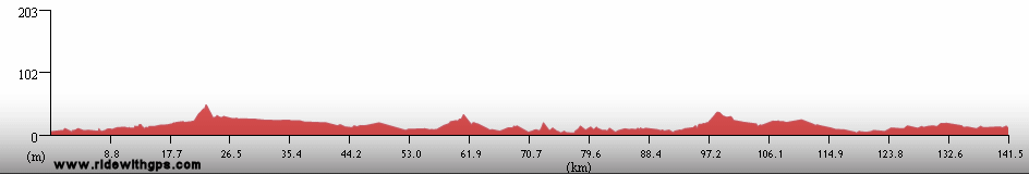
Lae to Lehro River
Distance: 104 km
Terrain: Flat to light rolling
Max. Elevation: 360 m
Roads: Highlands Hwy
Max. Temp: 31 °C
Weather: Morning rain, with a few downpours; partly cloudy afternoon, hot and humid; occasional tailwinds
Accommodation:
Comment: Half day in Lae for adjustment and sightseeing, then enjoyable ride in afternoon
July 19
Lehro River to Kainatu
Distance: 115 km
Terrain: Flat to light rolling; Hilly, 1060-m climb (Kassam Pass), 360-m climb
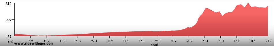
Max. Elevation: 1,660 m
Roads: Highlands Hwy
Max. Temp: 25 °C
Weather: Mostly cloudy, fog/mist/drizzle on the mountaintops
Accommodation:

Comment: People of Kainatu wouldn't let me go farther due to raskols
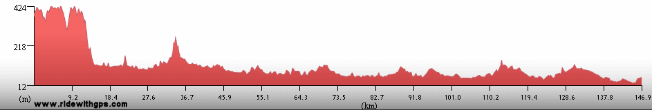
July 20
Kainatu to Goroka
Distance: 73 km
Terrain: Hilly
Max. Elevation: 1,495 m
Roads: Highlands Hwy
Max. Temp: 27 °C
Weather: Mostly sunny
Accommodation:
Comment: Half day; rest in Goroka in afternoon
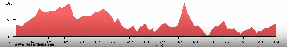
July 21
Goroka to Kudjip
Distance: 143 km
Terrain: Mountainous, 900-m climb and descent (Dualo Pass), 400-m climb and descent; moderate rolling
Max. Elevation: 2,480 m
Roads: Highlands Hwy (some rough spots)
Max. Temp: 29 °C
Weather: Mostly sunny
Accommodation:
Comment: A strenuous but beautiful day
July 22
Kudjip to Wabag
Distance: 145 km
Terrain: Mountainous, 1200-m climb and descent (Hagen Pass), 450-m climb
Max. Elevation: 2,780 m
Roads: Highlands Hwy, Wabag Hwy (numerous potholes)
Max. Temp: 25 °C
Weather: fog/mist/drizzle, with several dry periods
Accommodation:
Comment: Another tough day, beautiful scenery even with fog
July 23
Wabag
Max. Temp: 24 °C
Weather: Partly cloudy, afternoon/evening showers
Accommodation:
Comment: Rest day in Wabag
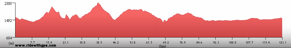
July 24
Wabag to Kaupena
Distance: 108 km
Terrain: Mountainous, 1200-m climb and descent (Hagen Pass), 450-m descent
Max. Elevation: 2,780 m
Roads: Wabag Hwy, Highlands Hwy
Max. Temp: 25 °C
Weather: Cloudy with occasional heavy showers
Accommodation:
Comment: Lots of climbing, but relatively easy day, finally found a good camp spot
July 25
Kaupena to Mendi
Distance: 107 km
Terrain: Hilly, 980-m climb
Max. Elevation: 2,290 m
Roads: Highlands Hwy (inc. 35 km very rocky gravel)
Max. Temp: 18 °C
Weather: Rain throughout day
Accommodation:

Comment: Very slow day due to bad weather, bad road, and rough terrain
July 26
Mendi to Kapo
Distance: 45 km
Terrain: Hilly
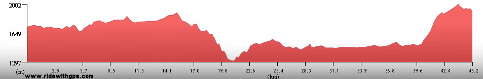
Max. Elevation: 2,200 m
Roads: Highlands Highway (horribly rocky)
Max. Temp: 22 °C
Weather: fog/cloudy
Accommodation:
Comment: Transfer to Tari; Rode a while, but road deteriorated, took a lift from Police to Tari
July 27
Tari
Max. Temp: 19 °C
Weather: Morning fog; partly cloudy afternoon
Accommodation:
Comment: Rest/sightseeing day in Tari; visited orchid gardens
July 28
Tari
Max. Temp: 20 °C
Weather: Morning fog; mostly sunny afternoon
Accommodation:
Comment: Rest/sightseeing day in Tari; visited nearby rainforest, met Huli men
July 29
Tari to Cairns
Accommodation:
Comment: Air tranfer to Cairns via Port Moresby
July 30
Cairns
Accommodation:
Comment: Rest/sightseeing day in Cairns; Kuranda Scenic Railroad and Skyrail Gondola, visited butterfly and bird aviaries
July 31
Cairns
Accommodation:
Comment: Sightseeing day in Cairns; Great Barrier Reef dives
August 1
Cairns
Accommodation:
Comment: Rest/recovery/chores day in Cairns
August 2
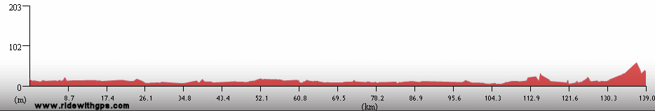
Cairns to 20-km E. of Mt. Garnet
Distance: 164 km
Terrain: Flat; 780-m climb, then hilly
Max. Elevation: 1,147 m
Roads: Hwy 1 (Bruce Hwy), Hwy 52, Hwy 1 (Kennedy Hwy)
Max. Temp: 19 °C
Weather: Cloudy with periods of mist/drizzle; strong headwinds/crosswinds
Accommodation:
Comment: A rather dreary day, but good distance despite terrain and dampness
August 3
20-km E. of Mt. Garnet to Mount Surprise
Distance: 164 km
Terrain: Moderate to light rolling
Max. Elevation: 822 m
Roads: Hwy 1 (Kennedy/Gulf Development Rd; one lane for long segments)
Max. Temp: 25 °C
Weather: Mostly sunny; strong cross/tailwinds
Accommodation:
Comment: Much better conditions, but felt tired most of the day; pleasantly light traffic; visited Undara Lava Caves
August 4
Mount Surprise to Gilbert River
Distance: 181 km
Terrain: Light to moderate rolling w/ 1 small hill, then flat
Max. Elevation: 566 m
Roads: Hwy 1
Max. Temp: 28 °C
Weather: Morning overcast, sunny afternoon, minimal wind
Accommodation:
Comment: Long, but fairly nice day, saw lots of wallabies
August 5
Gilbert River to 87 km E. of Normanton
Distance: 154 km
Terrain: Flat to light rolling
Max. Elevation: <300 m
Roads: Hwy 1
Max. Temp: 31 °C
Weather: Morning and evening clouds, sunny at midday; moderate tailwinds
Accommodation:
Comment: A pretty easy day
August 6
87 km E. of Normanton to Flinders River
Distance: 155 km
Terrain: Flat, light rolling
Max. Elevation: <300 m
Roads: Hwy 83
Max. Temp: 29 °C
Weather: Sunny; morning tailwinds, afternoon headwinds
Accommodation:
Comment: Tiring when going into wind, became longest tour today
August 7
Flinders River to Burke & Wills Roadhouse
Distance: 137 km
Terrain: Flat
Max. Elevation: <300 m
Roads: Hwy 83
Max. Temp: 29 °C
Weather: Overcast through morning, then sunny; moderate to strong headwinds
Accommodation:
Comment: Easy road, but winds and lack of services made a very tiring day
August 8
Burke & Wills Roadhouse
Max. Temp: 28 °C
Weather: Sunny
Accommodation:
Comment: Rest day at Burke & Wills Roadhouse
August 9
Burke & Wills Roadhouse to 30 km W. of Gregory Downs
Distance: 181 km
Terrain: Flat
Max. Elevation: <300 m
Roads: Wills Development Rd., Lawn Hill Rd. (reasonable qual. gravel)
Max. Temp: 31 °C
Weather: Sunny; light to moderate tailwinds
Accommodation:
Comment: Late start, but easy riding; only minimal food avail. at Gregory Downs
August 10
30 km W. of Gregory Downs to Adels Grove
Distance: 83 km
Terrain: Flat
Max. Elevation: <300 m
Roads: Lawn Hill Rd. (manegable gravel), Riversleigh Rd. (rough gravel)
Max. Temp: 29 °C
Weather: Sunny, light tail/cross winds
Accommodation:

Comment: Half day; rest at Adels Grove, sightseeing at Boodjamulla N.P.
August 11
Adels Grove to 120 km N.E. of Camooweal
Distance: 120 km
Terrain: Flat, moderate rolling
Max. Elevation: 360 m
Roads: Riversleigh Rd., Gregory-Camooweal Rd. (rough to manageable gravel)
Max. Temp: 30 °C
Weather: Mostly sunny
Accommodation:
Comment: A b-b-bumpy day, didn't get as far as hoped; visited Riversleigh Fossil Mammal Site
August 12
120 km N.E. of Camooweal to Camooweal
Distance: 122 km
Terrain: Flat
Max. Elevation: 320 m
Roads: Gregory-Camooweal Rd. (30 km rough, 90 km fair to good quality gravel)
Max. Temp: 26 °C
Weather: Sunny; strong cross/headwinds
Accommodation:
Comment: Better road, but last 30 km very tiring due to bad wind
August 13
Camooweal
Max. Temp: 25 °C
Weather: Sunny
Accommodation:
Comment: Rest day in Camooweal
Continued on Next Page
Index | Next Page
Pre-Tour Stage 1 Stage 2 Stage 3 Stage 4 Stage 5 |