
Stage 4: The Continent's Heart
My tropical Tour returns to
the tropics
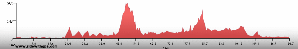
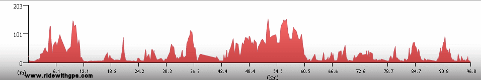
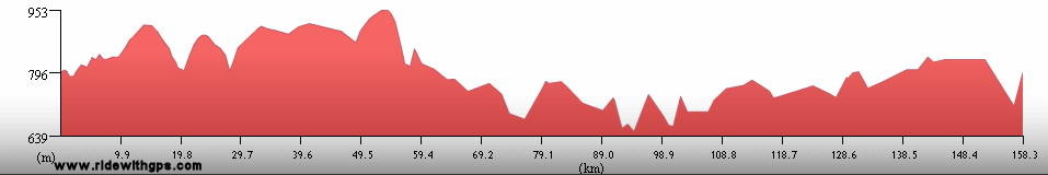
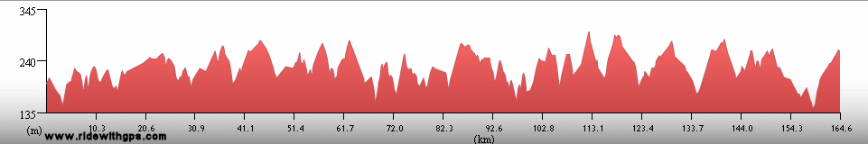
Stage 4 Actual Route

On this, and all other route maps, the blue lines represent travel by ship, red by airplane (Booo!), and green by bicycle.
Brazil: Big, Beautiful & Bird-filled
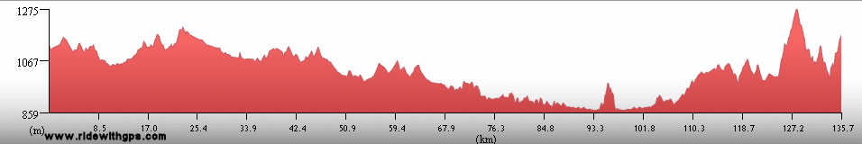
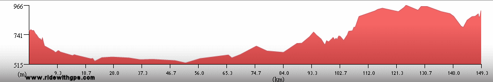
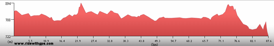
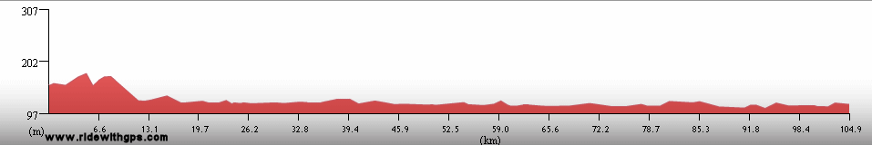
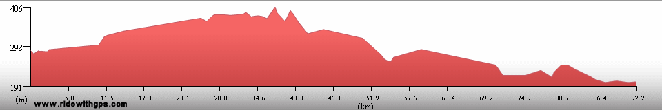
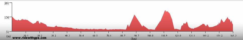
The largest country of the Tour so far, Brazil, with its productive climate and vibrant culture, was packed with interesting things to see. While I ultimately left much of the country unexplored, I felt that I did very well over all. Having revised my route many times due to the uncertainties of the sea transfer from Africa, the final route was a little longer than what I had first envisioned, and included a large number of destinations that I had not expected, but was anxious to see. The nation's culture, distinct from those of the rest of the continent, provided a nice change of pace compared to the Stage route up to that point, however, the corresponding change of language created nothing but opportunities for me to bungle any attempts at communication. It was the return of warmth, however, after six months in the chilly southern part of the continent that was perhaps the most appealing factor for me. Of course, it did not take many rides with afternoon highs in the vicinity of 40 °C for me to start pining for the good old days in Patagonia. It was a while before the heat became that severe, as my route began in the extreme southern states of Rio Grande do Sul and Santa Catarina, where July temperatures could still be a little brisk. While the climate chanced rather gradually, it didn't take long for me to realize that Brazil would be the best country of the Stage for wildlife viewing. That became apparent when I crossed the Lago Miriam Wildlife Refuge, which presented crocodiles, capybara, and abundant bird life.
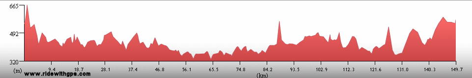
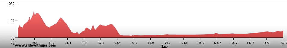
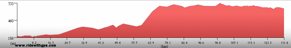
I then continued north, generally close to the coast, for a considerable distance, and though there were certainly some long sections of terrible, crowded highways and a number of chaotic urban centers in that region through which to navigate, there were also some pleasant attractions. One of those was a trip across the estuary of the Baia de Paranagua on small motor boats, which I undertook in order to avoid staying on the main highway, which curved inland towards the major city of Curitiba. That provided me an opportunity to see a small portion of the remaining remnants of the coastal Atlantic tropical forests. Also in that region was a surprisingly beautiful, and fairly quiet, road right along the coast between Santos and Rio de Janeiro. In addition to its green coastal mountains, that route included the charming colonial town of Paraty, one of my favorite towns of the Stage. Just a little farther was Rio itself, not the type of mega-city I would normally choose to visit during a tour, but one that I was drawn to as a nice location to take a short break from the rigors of the Stage so far.

Palms and crops in Rio Grande do Sul

A Southern Screamer

Shrine to Nossa Senhora da Conceição Aparecida

Baia de Paranagua

Boats and Sunset at Superagui

Iguape Cathedral

Blue Dacnis

The Costa Verde south of Rio

Rio de Janeiro
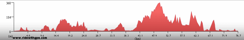
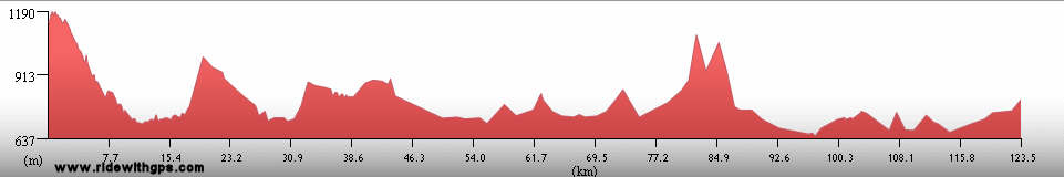
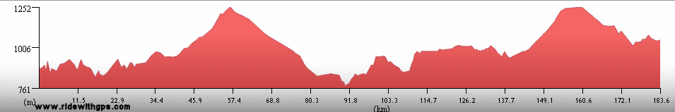
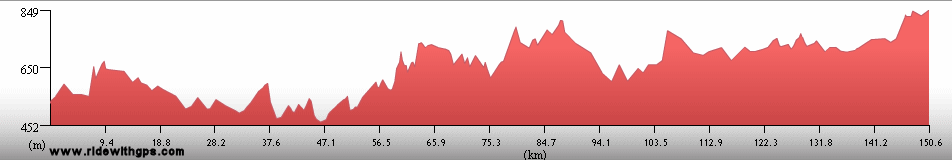
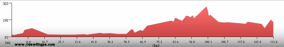
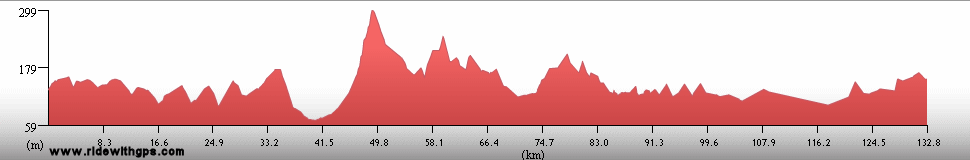
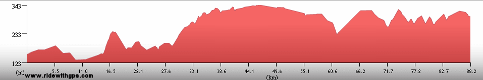
After a six-day break in Rio, in an environment completely opposite in character to any other part of the Stage, the rest of the route in Brazil left the influence of the Atlantic, and ventured into the interior of the continent. The start of that segment did not waste any time in replacing the mild terrain of the coastal route with the surprisingly rugged and ancient hills of the Brazilian Highlands. The pleasant and quiet countryside of that region typified most of the riding in that section, while the interesting attractions were a chain of colonial-era towns along the Estrada Real, the Royal Road, namely, Congonhas, Ouro Preto, Mariana, Serro, and Diamantina, which had their roots in a 18th century regional mining boom. After that pleasant region, my next stop was a rather surprising one, at least as far as I was concerned, the modernist national capital, Brasilia. I'm not really sure why I chose to go there, though, while it was not the easiest place to ride in and out of, it did provide an interesting counterpoint to the rest of the region. Beyond the capital, I visited yet another pleasant historic town, Goias, which had a quieter countenance than the others.
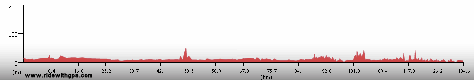
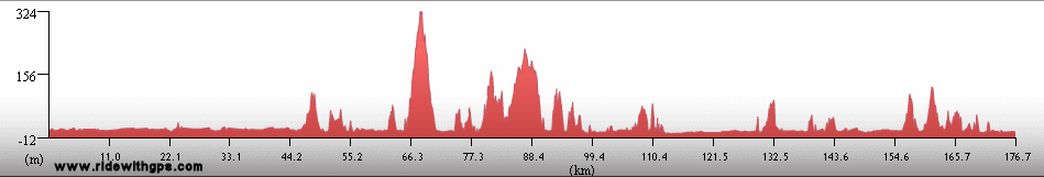
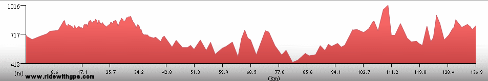
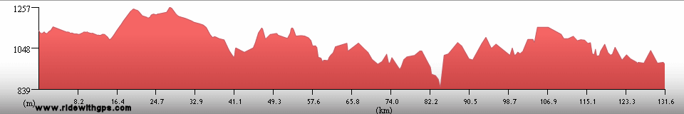
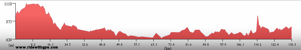
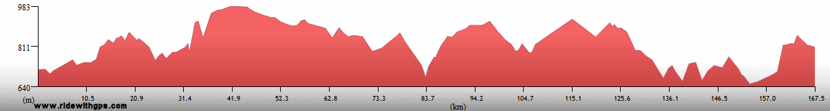
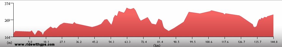
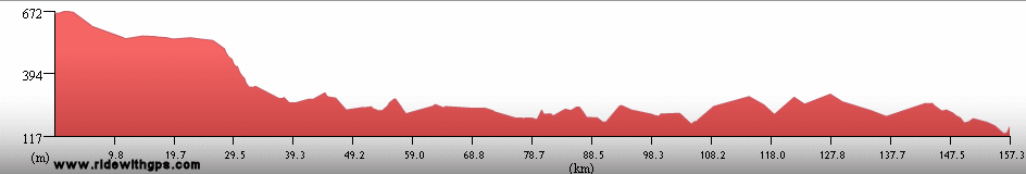
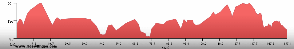
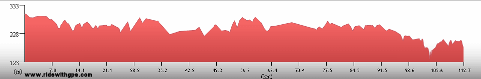
Continuing inland, I passed though an area of savanna that was much more extensive than I had expected, with my next major destination being the giant wetland known as the Pantanal. Along the way I took the opportunity to visit some of the last untouched examples of the region's grasslands at the Parque Nacional Emas. Even in the drier areas of the interior I continued to be impressed by the magnificence of the country's bird life, the most spectacular examples being my first ever sightings of free-flying Macaws and Toucans. After a surprisingly busy and stressful road to the regional capital of Cuiaba, I was ready to venture into the Pantanal, and while doing so by bike is not the most ideal method, I certainly wanted to do as much riding as I possibly could. That meant a ride to the dead-end, at the center of the wetlands, of the aborted Transpantaneria Highway, a road that was part dirt track and part wooden plank bridge, but a superb platform from which to observe birds and animals. I was fortunate, for once, to have arrived at the right time of the year, during the dry season, the only time when such a ride is possible. Once reaching the road's end, deep in the swamp, at Puerto Jofre, I crossed through the rest of the way on a pleasant, though quite expensive, sightseeing boat. That cruise deposited me at Corumba, at the country's southwest frontier. All that remained was a fairly easy ride through the ranching country of Matto Grosso do Sul, to the border with Paraguay.
Such a big land deserves a big post: ~HERE~

The historic town of Ouro Preto

Evening at Ouro Preto

A statue in Brasilia

Blue and Yellow Macaw in Parque Nacional das Emas

The Transpantanaeria Highway in the Pantanal

Jacares in the Pantanal

A family of Capybaras

Tocu Toucans
Paraguay: Land of a Perplexing Past
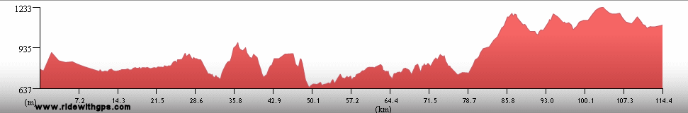
Paraguay is a country that was infrequently visited by tourists for many years, in part due to a long history of isolationism and dictatorial rulers. These days, the country is as open as any other, and while it doesn't possess major natural of historical attractions, unlike its neighbors, I was still very interested in visiting. I was pleasantly surprised by the agreeable conditions for cycling, in most areas, and that alone made my stay there quite enjoyable. I entered the country at its northern border with Brazil, and then reached the capital, Asuncion, after an easy ride through the mild agricultural terrain of the northern provinces. Though it was not the most beautiful of the cities I saw during the Stage, I stayed for a few days in order to catch up on my rest, and found it to be a nice place for that. The rest of my route was a winding circuit through the eastern part of the country, and included a stop at the frenzied market town of Ciudad del Este, which I used as a base for visiting Iguazu Falls in nearby Argentina and Brazil. My last days in the country were spent in its southeastern corner, an area once settled by German immigrants and, thanks to a delayed caused by some wet weather, I was able to enjoy a fun Oktoberfest party, albeit a fairly small one. The one major historic site I saw in the country, the ruins of the Jesuit Mission at Trinidad del Parana, was located in the same area.
A few additional details revealed in this post ~HERE~

Amambay Hills in northern Paraguay

Panteon de los Heroes in Asuncion

Harps, the national instrument of Paraguay

A display of Yerba Mate packages

Jesuit Mission at Trinidad del Parana
Previous | Next
Main Index | Pre-Tour Index
Post-Tour Index | Articles Index
Slideshows
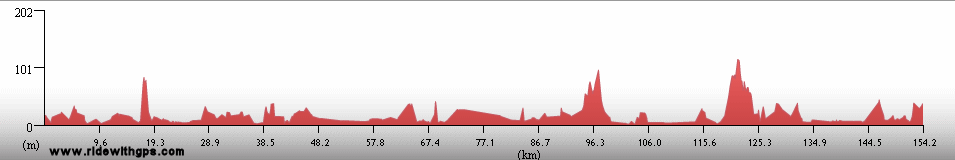
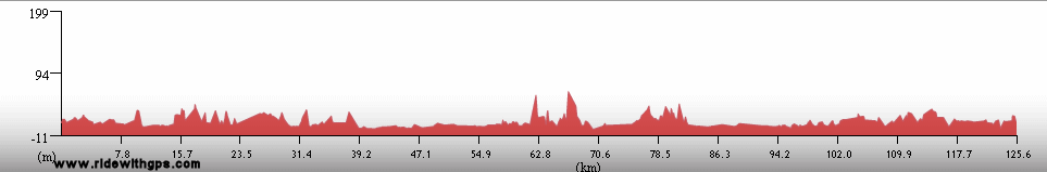
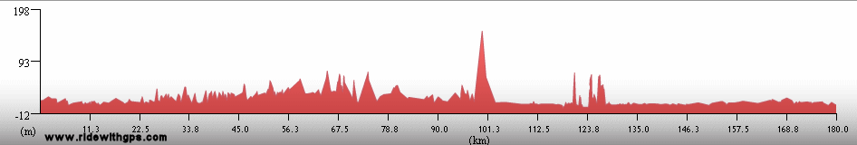
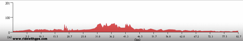
Stage 4 Log
(continued)
For a description of terms and symbols look: ~HERE~
July 15, 02007
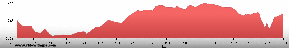
Santa Vitoria do Palmar to 25 km S. of Rio Grande
Distance: 199 km
Terrain: Flat
Max. Elevation: <300
Roads: BR 471
Max. Temp: 13 °C
Weather: Sunny; strong tail/crosswind, diminishing during afternoon
Accommodation:

Comment: Longest day of Stage so far, though considerably wind-assisted; minimal services on route; rode through Lagoa Mirim wetland Nature Reserve, saw Capybaras, caiman, and many many birds
July 16
Rio Grande
Distance: 32 km
Roads: BR 392
Accommodation:

Comment: Unplanned chores/rest day in Rio Grande
July 17
Rio Grande to Bujuru
Distance: 82 km
Terrain: Flat
Max. Elevation: <300 m
Roads: Lagoa dos Patos Ferry, BR 101 (last 27 km poor to terrible sand)
Max. Temp: 17 °C
Weather: Sunny in early morning, then mostly cloudy; moderate crosswinds
Accommodation:

Comment: A nice start, but day fell apart as soon as road turned bad; expected to go considerably farther
July 18
Bujuru to 14 km S. of Palamares do Sul
Distance: 187 km
Terrain: Flat
Max. Elevation: <300 m
Roads: BR 101 (3.5 km poor sand, then pavement but with many sections with numerous potholes)
Max. Temp: 18 °C
Weather: Early clouds, then sunny; strong to moderate tailwinds
Accommodation:
Comment: An easy day, made up for slow previous day
July 19
14 km S. of Palamares do Sul to Torres
Distance: 179 km
Terrain: Flat

Max. Elevation: <300 m
Roads: BR 101 (many potholes), RS 40, RS 784, RS 786 (fairly bumpy), RS 389, RS 498
Max. Temp: 22 °C
Weather: Sunny; moderate to strong crosswinds, ending in afternoon
Accommodation:
Comment: Another rather good day, though afternoon was better than morning
July 20
Torres
Accommodation:
Comment: Rest day in Torres
July 21
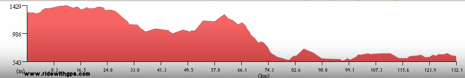
Torres to Jaguaruna
Distance: 137 km
Terrain: Flat, light to moderate rolling

Max. Elevation: <300 m
Roads: BR 101 (very heavy traffic; long sections under construction)
Max. Temp: 23 °C
Weather: Sunny, partly cloudy in afternoon; occasional light tail/crosswinds, becoming strong headwinds in afternoon
Accommodation:
Comment: A rather unpleasant day, mostly due to traffic on bad highway; was able to ride on portions of closed but recently-constructed sections, which helped a little; wanted to go a little farther, but got tired of conditions
July 22
Jaguaruna to Jaguaruna
Distance: 10 km
Accommodation:
Comment: Weather delay in Jaguarana; started to ride, but did not want to go on bad highway in steady rain; tried unpaved alternative, but surface was too soft
July 23
Jaguaruna to Sao Jose
Distance: 160 km
Terrain: Moderate rolling to flat, with a couple small hills
Max. Elevation: <300 m
Roads: BR 101 (heavy traffic, 80% of route under construction)
Max. Temp: 16 °C
Weather: Cloudy with moderate tailwinds; sunny with light crosswinds in afternoon
Accommodation:
Comment: Traffic and clouds made a tedious day
July 24
Sao Jose to Barra Velha
Distance: 138 km
Terrain: Moderate rolling to flat
Max. Elevation: <300 m
Roads: BR 101 (heavy traffic, several sections on frontage roads)
Max. Temp: 13 °C
Weather: Sunny until mid-morning, then cloudy; occasional light winds, various directions, but mostly cross/tailwinds
Accommodation:
Comment: A fairly annoying day; rode back into clouds from previous day; road in good condition, but traffic on wide highway was distracting; wanted to go farther, but felt a little worn out and actual distance longer than maps indicated
July 25
Barra Velha to Paranagua
Distance: 173 km
Terrain: Moderate rolling to flat
Max. Elevation: <300 m
Roads: BR 101 (heavy traffic), SC 415, PR 412, PR 407, local road
Max. Temp: 23 °C
Weather: Partly to mostly cloudy; occasional light tail/crosswinds
Accommodation:
Comment: A stressful first half, then a pleasant second half after finally leaving stupid highway
July 26
Superagui
Accommodation:
Comment: Boat transfer to Superagui for sightseeing day in Superagui National Park; small boat could not handle rough seas, so had to walk along beach for last few km.
July 27
Cananeia to Iguape
Distance: 91 km
Terrain: Flat; moderate rolling; flat
Max. Elevation: <300 m
Roads: SP 226, SP 222
Max. Temp: 24 °C
Weather: Sunny; occasional mild to light winds, various directions
Accommodation:
Comment: A beautiful day; boat transfers to Cananeia, via Ihla do Cardoso, then a pleasant half day; would have liked to have a full day, but transfer took longer than hoped; stayed in beautiful colonial town of Iguape; saw many beautiful birds
July 28
Iguape to Peruibe
Distance: 119 km
Terrain: Light to moderate rolling, with two small climbs/descents
Max Elevation: <300 m
Roads: SP 222, BR 116 (heavy traffic) SP 55 (narrow, somewhat bumpy, and far too much traffic and too many trucks)
Max. Temp: 12 °C
Weather: Cloudy, light rain/mist in morning and evening
Accommodation:
Comment: Complete reversal from previous day, cool, damp, and bad roads; wanted to go considerably farther, but delayed by rain and multiple tube repairs
July 29
Peruibe to Bertioga
Distance: 139 km
Terrain: Light rolling to flat
Max. Elevation: <300 m
Roads: Local road, SP 55, local roads, Santos-Garuja ferry, SP 61, Bertioga ferry
Max. Temp: 17 °C
Weather: Mostly cloudy, with a couple brief, light showers through morning, mostly sunny in afternoon
Accommodation:
Comment: A better day; early part of route still with traffic, but road wide and in better condition; wanted to go somewhat farther but delayed by slow navigation through cities and unexpected second ferry
July 30
Bertioga to Ubatuba
Distance: 172 km
Terrain: Light rolling to flat; very steep 310-m climb/descent; hilly with some steep grades; moderate to heavy rolling
Max. Elevation: 314 m
Roads: SP 55
Max. Temp: 19 °C
Weather: Mostly sunny, with some cloudier periods, occasional light cross/headwinds in afternoon
Accommodation:
Comment: A nice day, but a little tougher than expected
July 31
Ubatuba to Paraty
Distance: 85 km
Terrain: Light rolling to hilly; 310-m climb/rolling descent
Max. Elevation: 315 m
Roads: BR 101
Max. Temp: 20 °C
Weather: Sunny; light crosswinds in afternoon
Accommodation:
Comment: Planned on a full day, but decided to stop after a half day in nice colonial town of Paraty; will need to transfer into Rio to make up lost time, but probably not a bad idea anyway
August 1
Paraty to Angra dos Reis
Distance: 100 km
Terrain: Light to heavy rolling
Max. Elevation: <300 m
Roads: BR 101
Max. Temp: 24 °C
Weather: Sunny
Accommodation:
Comment: Short day followed by bus transfer to Rio de Janeiro; first part of skipped section looked reasonable but not really pleasant, then got worse with multiple tunnels; a good idea to transfer
August 2-7
Rio de Janeiro
Accommodation:
Comment: Long Rest/sightseeing break in Rio; visited Pao do Azucar, Cristo Redentor, beaches
August 8
Rio de Janeiro to Petropolis
Distance: 38 km
Terrain: 780-m climb
Max. Elevation: 855 m
Roads: Rd. 107 (cobbled)
Max. Temp: 31 °C
Weather: Partly sunny
Accommodation:
Comment: Ride through the city before a surprisingly slow rail transfer to the outskirts, then short, but steep, ride to Petropolis
August 9
Petropolis to Juiz de Fora
Distance: 119 km
Terrain: Moderate rolling, with gradual descent; 300-m descent, broken 510-m climb
Max. Elevation: 820 m
Roads: Cascatihna Rd., BR 40
Max. Temp: 27 °C
Weather: Partly sunny; occasional light to moderate winds, various directions
Accommodation:
Comment: Short, but relatively easy day
August 10
Juiz de Fora to Barbacena
Distance: 100 km
Terrain: Moderate rolling; 500-m climb, broken by small descent
Max Elevation: 1,190 m
Roads: BR 40
Max. Temp: 24°C
Weather: Cloudy in early morning, then mostly sunny
Accommodation:
Comment: Another short day; felt rather tired and stopped early to give a better schedule for upcoming sights
August 11
Barbacena to 15 km S. of Ouro Preto
Distance: 141 km
Terrain: Moderate rolling; hilly; 320-m climb; hilly
Max. Elevation: 1,297 m
Roads: BR 40 (mostly narrow, moderate to heavy traffic), MG 443 (some bumpy sections)
Max. Temp: 24 °C
Weather: Partly sunny, becoming mostly cloudy by afternoon
Accommodation:
Comment: A fairly reasonable day, despite busy highway; stopped just outside town due to darkness and heavy terrain; visited Basilica do Senhor Bom Jesus in Congonhas
August 12
Ouro Preto
Distance: 19 km
Accommodation:
Comment: Short ride to sightseeing day in the colonial mining town of Ouro Preto
August 13
Ouro Preto to 18 km S. of Itabira
Distance: 139 km
Terrain: 1 400-m descent; hilly; moderate rolling to hilly
Max. Elevation: 1,180 m
Roads: MG 262, MG 129, MG 438, BR 381, MG 434
Max. Temp: 25 °C
Weather: Clouds through mid morning, then partly sunny; occasional light winds, various directions
Accommodation:
Comment: A rather slow start, with brief visit to historic town of Mariana and rather tough terrain; some sections quiet, others with traffic; a few ugly mines on route
August 14
18 km S. of Itabira to Senhora do Porto
Distance: 153 km
Terrain: Moderate rolling to hilly
Max. Elevation: 890 m
Roads: BR 120
Max. Temp: 27 °C
Weather: Morning clouds, then mostly sunny; occasional light to moderate headwinds in afternoon
Accommodation:
Comment: A nice day; some pleasant conditions and nice scenery north of Itabira
August 15
Senhora do Porto to Pedro Lassa
Distance: 115 km
Terrain: Hilly to moderate rolling; 450-m climb, broken by small descent
Max Elevation: 1,180 m
Roads: BR 120, BR 259
Max. Temp: 28 °C
Weather: Morning clouds, then mostly sunny; occasional moderate tailwinds
Accommodation:
Comment: Another nice day, but slower and shorter than expected; planned on reaching next stop, but distance farther than map indicated and terrain somewhat tougher; spent some extra time visiting historic town of Serro
August 16
Pedro Lassa to Diamantina
Distance: 65 km
Terrain: Hilly
Max. Elevation: 1,375 m
Roads: BR 259, BR 367
Max. Temp: 25 °C
Weather: Mostly sunny; moderate to strong tailwinds, becoming cross/headwinds
Accommodation:
Comment: Short half day to break in Diamantina
August 17-18
Diamantina
Accommodation:
Comment: Sightseeing/rest days in Diamantina; visited historic town center; came down with mild head cold
August 19
Diamantina to Curvelo
Distance: 133 km
Terrain: Hilly; 600-m descent, broken by short climb; moderate rolling
Max Elevation: 1,375 m
Roads: BR 367, BR 259
Max. Temp: 30 °C
Weather: Partly cloudy during morning, then sunny; light to moderate tail/crosswinds,diminishing in afternoon
Accommodation:
Comment: A reasonable day, considering; planned to go somewhat farther, but not feeling 100% yet
August 20
Curvelo to Tres Marias
Distance: 128 km
Terrain: Light rolling to flat; hilly
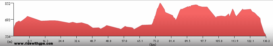
Max. Elevation: 844 m
Roads: BR 259 (somewhat bumpy),BR 40
Max. Temp: 28 °C
Weather: Sunny
Accommodation:
Comment: A very late start due to long search for a usable ATM; felt very sleepy all day; hoped to go considerably farther
August 21
Tres Marias to Joao Pinheiro
Distance: 142 km
Terrain: Hilly; light rolling to hilly
Max. Elevation: 932 m
Roads: BR 40 (periods of heavy truck traffic)
Max. Temp: 28 °C
Weather: Sunny; light tailwind in afternoon
Accommodation:
Comment: A mixed day, reasonable progress, but occasional traffic not pleasant; had hoped to go considerably farther, but pace still down
August 22
Joao Pinheiro to Goias Border
Distance: 151 km
Terrain: Light rolling to flat with gradual descent; hilly
Max. Elevation: 975 m
Roads: BR 40
Max. Temp: 28 °C
Weather: Sunny; light tail- to cross/tailwinds
Accommodation:
Comment: A reasonable, though uneventful day; traffic still fairly heavy, but road in better condition, so less of a problem; wanted to go slightly farther, but slowed by terrain in evening
August 23
Goias Border to Brasilia
Distance: 184 km
Terrain: Hilly; 350-m climb
Max. Elevation: 1,280 m
Roads: BR 40, DF 03
Max. Temp: 28 °C
Weather: Sunny, with considerable smoke/haze from many brush fires; moderate crosswinds, diminishing in afternoon
Accommodation:
Comment: A longer day than maps/signs indicated; rode to edge of city by sundown, then took taxi into center
August 24-26
Brasilia
Accommodation:
Comment: Rest days in Brasilia; visited Modernist government buildings
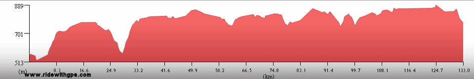
August 27
Brasilia to Corumba
de Goias
Distance: 133 km
Terrain: Hilly to light rolling
Max. Elevation: 1,240 m
Roads: Local highways, BR 70 (some bumpy sections); BR 414
Max. Temp: 32 °C
Weather: Morning clouds, then mostly sunny; mild tailwinds
Accommodation:
Comment: A disappointingly slow and short day; heavy congestion on highways leaving city; actual distance considerably longer than maps indicated
August 28
Corumba de Goias to Santa Rosa de Goias
Distance: 134 km
Terrain: Hilly
Max. Elevation: 1,050 m
Roads: GO 225, GO 431, BR 153 (bumpy), GO 80, GO 330, GO 320 (fair to good dirt)
Max. Temp: 33 °C
Weather: Sunny, with considerable smoke/haze; occasional mild tailwinds
Accommodation:
Comment: Another day where hoped to go somewhat farther
August 29
Santa Rosa de Goias to Goias
Distance: 91 km
Terrain: Moderate to heavy rolling
Max. Elevation: 930 m
Roads: GO 320 (good to fair dirt), GO 154, GO 70
Max. Temp: 35 °C
Weather: Sunny; light tailwind
Accommodation:
Comment: Half day to break in Goias
August 30
Goias
Accommodation:
Comment: Sightseeing day in Goias; visited colonial mining town
August 31
Goias to Israelandia
Distance: 169 km
Terrain: Light to moderate rolling, with a couple small hills
Max. Elevation: 640 m
Roads: GO 70 (many bumpy sections), BR 70, GO 324, GO 418 (somewhat bumpy), BR 60 (somewhat bumpy)
Max. Temp: 32 °C
Weather: Sunny; moderate tailwinds until rote turned south, the occasional light crosswinds
Accommodation:
Comment: A generally good day,though would have preferred smoother roads
September 1
Israelandia to 13 km S. of Caiaponia
Distance: 152 km
Terrain: Light rolling to hilly
Max. Elevation: 870 m
Roads: GO 60 (somewhat bumpy), GO 221, BR 158
Max. Temp: 34 °C
Weather: Sunny; occasional mild to light tail/crosswinds through morning
Accommodation:
Comment: A reasonable, but somewhat tiring day
September 2
13 km S. of Caiaponia to Minieros
Distance: 171 km
Terrain: Hilly to light rolling
Max. Elevation: 1020 m
Roads: BR 158, GO 220, GO 50 (bumpy), BR 364 (fairly heavy traffic; shoulder only good some of the time)
Max. Temp: 33 °C
Weather: Sunny; occasional mild to light cross/tailwinds through morning
Accommodation:
Comment: A somewhat tougher day, but reached planned destination
September 3
Minieros
Accommodation:
Comment: Rest day in Minieros, wanted to visit National Park, but took too long to make arrangements
September 4
Minieros
Accommodation:
Comment: Sightseeing day in Minieros; visited Parque Nacional Emas
September 5
Minieros to Alta Garcas
Distance: 156 km
Terrain: Moderate to light rolling
Max. Elevation: 970 m
Roads: BR 364
Max. Temp: 31 °C
Weather: Sunny; moderate to strong tail/crosswinds, diminishing and becoming occasional in afternoon
Accommodation:
Comment: A mixed day; initial and final sections not very pleasant with heavy truck traffic on poor road; long section in middle with good shoulder and nice wind was very easy; stopped slightly earlier than planned to avoid riding into setting Sun on busy highway
September 6
Alta Garcas to Rondonopolis
Distance: 155 km
Terrain: Light rolling, 370-m descent (bumpy); moderate rolling
Max Elevation: 830 m
Roads: BR 364
Max. Temp: 33 °C
Weather: Sunny; moderate to strong tail/crosswinds
Accommodation:
Comment: A fast, but not especially enjoyable day; generally good conditions except for fairly long section without good shoulder; very heavy truck traffic
September 7
Rondonopolis
Accommodation:
Comment: Unplanned rest day to avoid arriving in Cuiaba at start of weekend; city closed and deserted due to Independence Day holiday
September 8
Rondonopolis to Pensoa Seco
Distance: 102 km
Terrain: Moderate to heavy rolling; gradual, rolling 400-m climb

Max. Elevation: 748 m
Roads: BR 364
Max. Temp: 34 °C
Weather: Sunny; lack of wind caused heavy smog
Accommodation:
Comment: A short and surprisingly slow day, though not really necessary to go much farther; way too many trucks on highway, shoulder only fair to poor on most of route
September 9
Pensoa Seco to Cuiaba
Distance: 120 km
Terrain: Moderate rolling; 400-m descent (bumpy, narrow, heavy traffic)
Max Elevation: 900 m
Roads: BR 364
Max. Temp: 39°C
Weather: Sunny; occasional light crosswinds
Accommodation:
Comment: Very heavy truck traffic during rather short day to break in Cuiaba; hottest day of Stage so far
September 10-13
Cuiaba
Accommodation:
Comment: Rest/errands day in Cuiaba; was not able to get second visa extension, will have to pay overstay fine, but similar in cost; delay due to Pantanal boat schedules
September 14
Cuiaba to Pocone
Distance: 110 km
Terrain: Light rolling to flat
Max. Elevation: 330 m
Roads: BR 70, MT 60
Max. Temp: 40 °C
Weather: Smoke-obscured Sun; light to moderate tailwind, ending in afternoon
Accommodation:
Comment: Lazily-paced short day to Pocone; had planned to go a little farther, but shortened day to escape heat and buy supplies for next day
September 15
Pocone to Jaguar Lodge
Distance: 111 km
Terrain: Flat to light rolling, flat
Max. Elevation: <300 m
Roads: MT 60 (first 40 km fair dirt/gravel with many corrugated sections, remainder good dirt/gravel)
Max. Temp: 34 °C
Weather: Thick smoke
Accommodation:
Comment: Reasonable day, entered the Pantanal, though would have like to have gone slightly farther; smoke made temperature slightly cooler, but early condition of road slowed progress; amazing numbers ad variety of birds
September 16
Jaguar Lodge to Porto Jofre
Distance: 38 km

Accommodation:

Comment: Short ride to Porto Jofre for boat transfer to Corumba
September 17
Barco Peralta
Accommodation:
Comment: Boat transfer through Pantanal to Corumba on the riverboat Barco Peralta
September 18
Corumba
Accommodation:
Comment: Morning arrival in Corumba, rest/chores for rest of day
September 19
Corumba to 60 km W. of Mirinda
Distance: 165 km
Terrain: Light rolling; flat
Max. Elevation: <300 m
Roads: BR 262
Max. Temp: 34 °C
Weather: Smoky sun; occasional light tail/crosswinds, calm at midday
Accommodation:
Comment: A good day; pleasantly light traffic; minimal services on route; another good day for bird sightings
September 20
60 km W. of Mirinda to Anastacio
Distance: 130 km
Terrain: Flat; moderate to heavy rolling
Max. Elevation: 350 m
Roads: BR 262
Max. Temp: 38 °C
Weather: Thick smoke; light afternoon cross/tailwinds
Accommodation:
Comment: A rather tiresome day; increased traffic in afternoon; planned to go somewhat farther, but stopped early to stay indoors away from smoke and heat
September 21
Anastacio to Jardim
Distance: 143 km
Terrain: Light rolling to flat
Max. Elevation: 403 m
Roads: BR 419, BR 267
Max. Temp: 38 °C
Weather: Sunny, obscured by smoke; light tailwinds
Accommodation:
Comment: A generally good, easy day, except for heat and smoke
September 22
Jardim to Bela Vista
Distance: 92 km
Terrain: Light rolling
Max. Elevation: 440 m
Roads: BR 60
Max. Temp: 37 °C
Weather: Sunny, obscured by smoke; light tailwinds
Accommodation:
Comment: A fairly easy half day; considered crossing border at Bela Vista, but frontier did not have immigration station
September 23
Bela Vista to Pedro Juan Caballero, Paraguay
Distance: 139 km
Terrain: Light to moderate rolling; 350-m climb; light rolling
Max. Elevation: 725 m
Roads: MS 384, MS 164
Max. Temp: 34 °C
Weather: Sunny, smoky through morning, clearing in afternoon; light tailwinds, beginning in late morning, becoming strong in afternoon
Accommodation:
Comment: Another fairly easy day to the Paraguay border; actual distance somewhat longer than map indicated
September 24
Pedro Juan Caballero
Accommodation:
Comment: Rest day in Pedro Juan Caballero
September 25
Pedro Juan Caballero to Azotey
Distance: 159 km
Terrain: Light rolling, one small descent
Max. Elevation: 650 m
Roads: Ruta 5, Ruta 3
Max. Temp: 27 °C
Weather: Sunny to mostly sunny; moderate to strong tailwinds through morning, then light to moderate headwinds in afternoon after route turned south
Accommodation:
Comment: An excellent day; fine riding conditions, except for late headwinds; some nice scenery
September 26
Azotey to San Estanislao
Distance: 155 km
Terrain: Light to moderate rolling
Max. Elevation: <300 m
Roads: Ruta 3
Max. Temp: 30 °C
Weather: Mostly sunny; moderate crosswinds
Accommodation:
Comment: Another good day, though a little slower and less scenic than previous
September 27
San Estanislao to Asuncion
Distance: 167 km
Terrain: Light to moderate rolling; flat; light to moderate rolling
Max Elevation: <300 m
Roads: Ruta 3
Max. Temp: 32°C
Weather: Morning clouds, then sunny
Accommodation:
Comment: A relatively easy day, but not especially interesting; traffic increased only slightly until well into city
September 28-30
Asuncion
Accommodation:
Comment: Rest/sightseeing days in Asuncion
October 1
Asuncion to Coronel Oviedo
Distance: 138 km
Terrain: Light rolling; one small climb; moderate rolling
Max. Elevation: <300 m
Roads: Ruta 2
Max. Temp: 33 °C
Weather: Sunny; strong headwinds, diminishing somewhat in afternoon
Accommodation:
Comment: A rather tiresome day; heavy traffic leaving city; first 70 km of highway had good shoulder but it wad ruined by idiotic speed-bumps every 20m, less of a problem later on; wanted to go somewhat farther, but slowed by late start, winds, and messed-up road
October 2
Coronel Oviedo to Dr. J. E. Estigarribia
Distance: 84 km
Terrain: Moderate rolling with a couple small climbs; moderate to heavy rolling
Max Elevation: <300 m
Roads: Ruta 7
Max. Temp: 35°C
Weather: Sunny; moderate head/crosswinds
Accommodation:
Comment: Slow half day; planned on doing a full day, but was not really necessary. Road in better condition, but wind was tiring, so decided to stop early
October 3
Dr. J. E. Estigarribia to Cuidad del Este
Distance: 115 km
Terrain: Moderate rolling; moderate to heavy rolling
Max. Elevation: 364 m
Roads: Ruta 7
Max. Temp: 34 °C
Weather: Hazy sunshine; moderate cross/headwinds
Accommodation:
Comment: A reasonable, though rather uninteresting short day; moderate traffic approaching city
October 4
Puerto Iguazu, Argentina
Distance: 27 km
Accommodation:
Comment: Short ride to a break in Puerto Iguazu; confusion about visa requirements for brief transit through Brazil; was allowed to cross without expensive visa
October 5
Puerto Iguazu
Distance: 36 km
Accommodation:
Comment: Sightseeing day in Puerto Iguazu; visited Iguazu National Park and Iguazu Falls; very impressed, will stay another day
October 6
Puerto Iguazu
Accommodation:
Comment: Sightseeing day in Puerto Iguazu; visited Iguazu National Park
October 7
Cuidad del Este
Distance: 32 km
Accommodation:
Comment: Short ride back to Paraguay, with sightseeing stops at Parque Nacional Iguacu (Brazil), and Parque das Aves bird park
October 8
Cuidad del Este
Accommodation:
Comment: Rest/errands/repairs day in Cuidad del Este; feeling a little ill
October 9
Cuidad del Este to Maria Auxiliadora
Distance: 165 km
Terrain: Light rolling; light to heavy rolling
Max. Elevation: 355 m
Roads: Ruta 7, Ruta 6
Max. Temp: 34 °C
Weather: Sunny; moderate to strong tailwinds, diminishing during afternoon
Accommodation:
Comment: Not feeling quite 100%, but still a fairly easy day thanks to some mild terrain and nice wind; sections of shoulder ruined by speed-bumps, others reasonably good
October 10
Maria Auxiliadora to Bella Vista
Distance: 75 km
Terrain: Moderate rolling
Max. Elevation: <300 m
Roads: Ruta 6
Max. Temp: 26 °C
Weather: Periods of thunderstorms, light rain, and cloudiness; strong headwinds during showers
Accommodation:
Comment: Dreary half day to Bella Vista, though took most of day due to weather stops
October 11-12
Bella Vista
Accommodation:
Comment: Weather delay in Bella Vista
October 13
Bella Vista
Distance: 42 km
Accommodation:
Comment: Sightseeing day; visited Jesuit mission ruins in Trinadad del Parana
October 14
Bella Vista
Accommodation:
Comment: Weather delay in Bella Vista
October 15
Bella Vista to Encarnacion
Distance: 49 km
Terrain: Moderate rolling
Max. Elevation: <300 m
Roads: Ruta 6
Max. Temp: 27 °C
Weather: Cloudy, periods of light drizzle
Accommodation:
Comment: Short half day to Encarnacion
Continued on Next Page
Index | Next Page
Pre-Tour Stage 1 Stage 2 Stage 3 Stage 4 Stage 5 |